Introduction to today's journey
Ho Pukonga mai, he nohoanga tangata, ho nofoanga tangata, ho putanga kororo.
Where waters gather, people settle, and where people settle, legends unfold.
- Maori proverb
THE WAIMARINO Block of half a million acres was purchased from the Maori owners in 1886 in what is now recognised as an unfair deal. It was divided into smaller blocks to be given to the families of returning pakeha soldiers of World War I (1914-1918) following the passing of the Discharged Soldiers Settlement Act, 1915. The Mangapurua Soldier Settlement formed part of this block and became the last and largest of these schemes throughout New Zealand. Each soldier was allocated a block by ballot. They were given a piece of paper containing the deed and a description of the location and boundaries. Little did they realise how difficult the country around Mangapurua was, and little did they know that a few decades later, their promised land would forever become known as the valley of abandoned dreams.
Today's journey continues downstream from Mangawaiiti eventually reaching a large rock from where a track began. We followed this track for some distance before reaching The Bridge To Nowhere. After stopping there we returned to the river and continued paddling downstream to the Tieke Kainga marae and camping directly across the river at Ramanui.
Today's Journey
Distance trekked today: 23.5 kilometres.
Total distance trekked to date: 107.0 kilometres.
 |
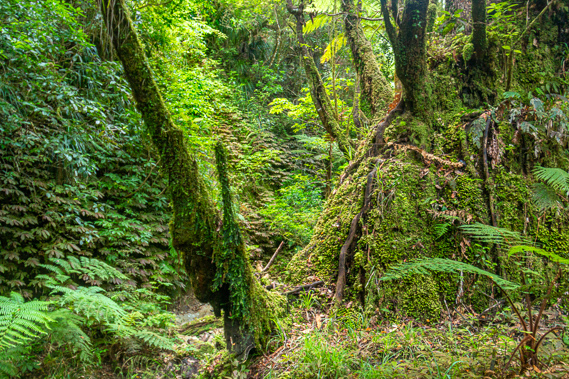
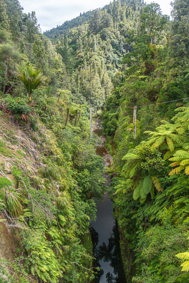
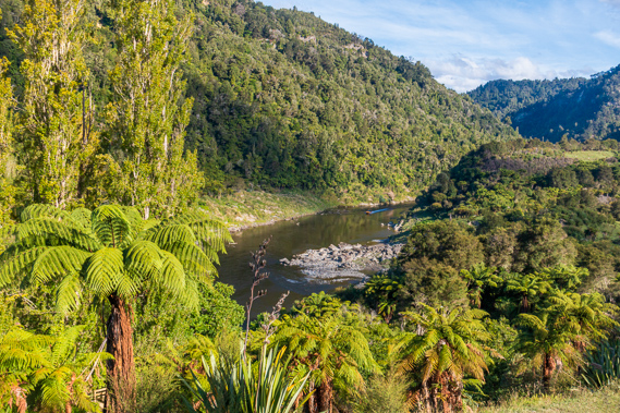
07:14 - I awake at first light to a cool, damp morning with the drips of a heavy dew starting to run down the outside of my tent fly. Everyone else is sound asleep in the still camping ground. Only a couple of decades ago the chorus of birdsong here would have been almost deafening. Today there is not a single bird despite the remoteness of this part of the river. I head down to the gorge where the brown almost mirror smooth water slides mournfully by with its eternal broken trail of bubbles from the Log Jam further upstream. Our canoes sit silently at the bottom of the muddy bank where the layers of mudstone dip towards the water creating the weird illusion that the water is sloping quite steeply upwards against the flow. |
 |
07:21 - The cushion of the thin layer of cloud subtly captures the first rays of the morning sunrise as it encases the still breathless air of the gorge. The big slip across the river and the obvious line under which the vegetation has been stripped away remain a silent reminder of the raging torrents that can flood through here when the water level rises by up to twenty metres. We have been fortunate in only having a couple of hours of moderate rain so far on this trip. Although cloud completely covers the sky, the weather forecast for today and tomorrow is for fine weather, with rain arriving sometime over the day following our last on the river. Any massive storm would render the river unsafe forcing us to be stuck here sometimes for days waiting for the river to drop. |
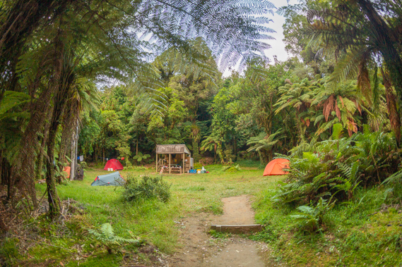 |
07:24 - I return to the camp ground where Cameron is starting to prepare breakfast. The others all join us over the following minutes. They all mention the ground was rather lumpy last night due to the roots and slope of the sites. Cameron quite happily announces this has been our last night in tents and we will be staying in huts tonight. Tomorrow we will be back at the lodge at Ohakune. Off from the far end of the table are the stacked red and white drums of the other couple, who have not risen yet. Their drums are about half the volume of ours, as had the drums of the other couples we had stayed with in the past two nights. These would be a lot easier to carry up and down the steep banks than our large drums. Looking over the camping ground there definitely is room for quite a few more tents, as I imagine it will be during the peak holiday season. Such a crowd would be chaos though so thankfully we are doing the trip a few weeks after the end of the school holidays. |
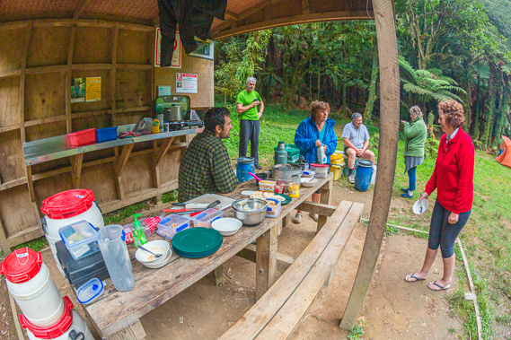 |
08:49 - With breakfast prepared we relax and eat cereal. We only have nineteen kilometres to paddle today, but there is going to be a hike to the Bridge to Nowhere later this morning, making it a longer day of travel than yesterday. Once breakfast is finished, we start packing up just as the other couple are getting up. Thankfully our tents are dry as they will remain packed up until we return to Ohakune tomorrow afternoon. I return the comfortable mattress to its owner and take the one I had originally loaned as we will be sleeping in huts tonight. |
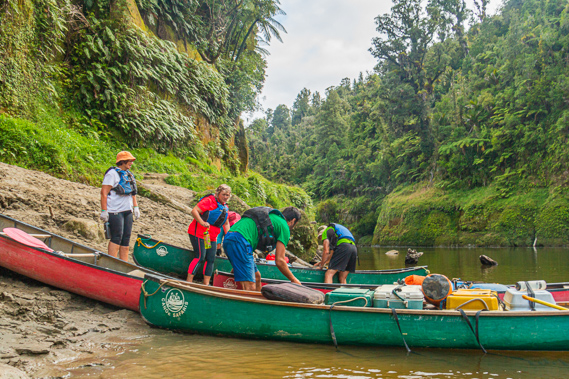 |
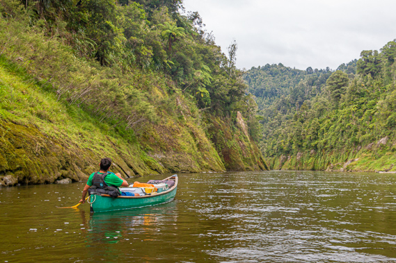
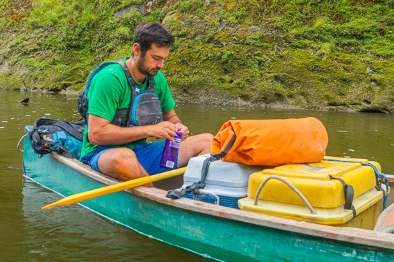
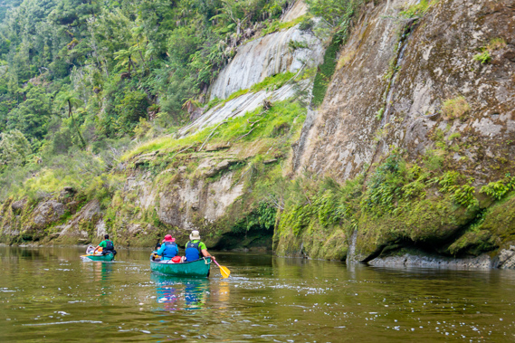
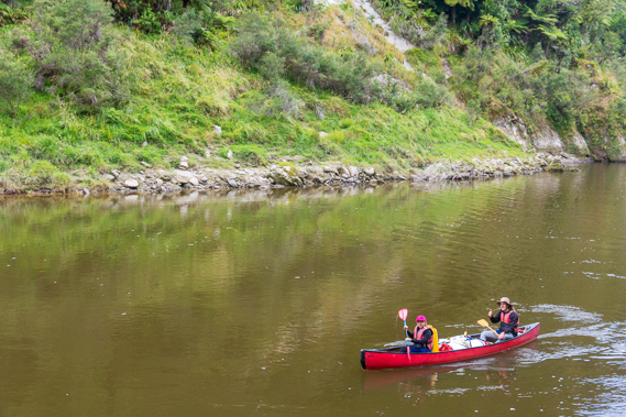
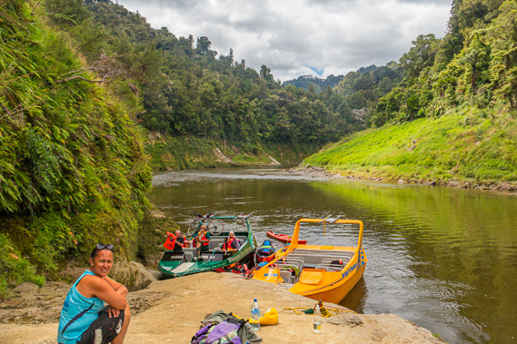
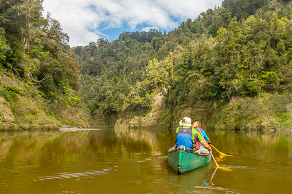
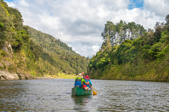
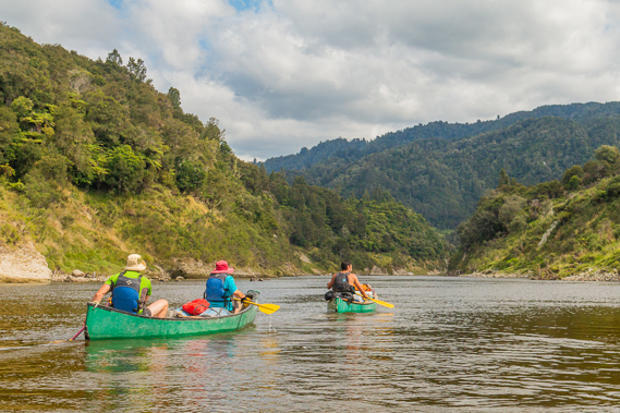
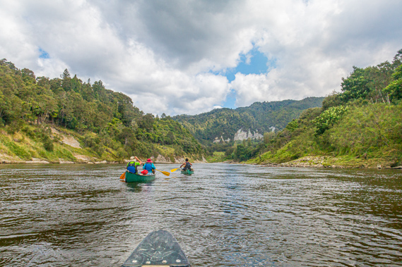
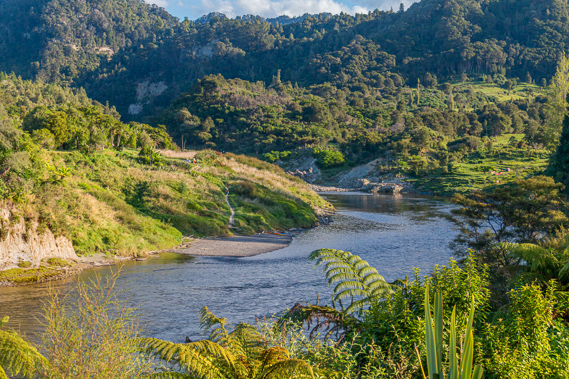
09:29 - The sandy path is easy to walk down up to the start of the little slip where the ground becomes very muddy. It is a bit of an acrobatic act getting everything into the canoes, but after a couple of trips we are loaded up ready to go. My boat is cast off first into the mirror flat calm water. Once more we have the container of drinking water in our canoe to balance out our differences in weight. From here we have 19 kilometres to tonight’s accommodation at Ramanui and 40.5 kilometres to Pipiriki. With 83.5 kilometres of river behind us, we are more than two thirds of the way downstream. |
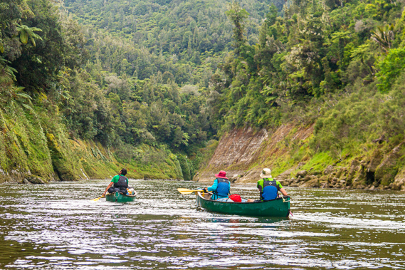 |
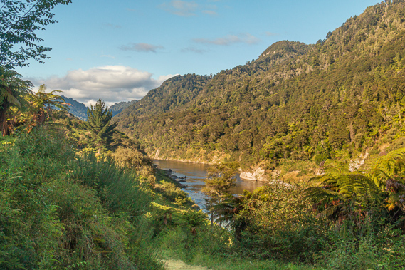
09:53 - The water remains mirror flat as we paddle to the end of the short reach where we turn a sharp bend almost 180 degrees to head in the opposite direction. At the end of the bend the river funnels into the Matawhero Rapid passing a small shingle bank to the right and a longer shingle bank to the left. The water becomes moderately turbulent in the vee but gradually eases as the river sharply turns to the left to avoid several large boulders poking up in the middle of the river. |
 |
09:58 - As soon as we complete the 180 degree bend, the river starts a gradual thirty degree bend to the right. About half way around this gradual bend we enter the first part of the Whatakaka Rapid at a landslide to the right which has deposited huge boulders narrowing the channel. There is almost no turbulence though. As the river straightens out we pass through the rest of the Whatakaka Rapid which has almost no turbulence at all. We continue along the short reach from where we see the Otumangu Landing at the end of the reach to the left at the mouth of a stream with the same name. It consists of a small level rock platform about a metre above the water with an iron stanchion. From here a track follows the river upstream across the moss covered cliff before doubling back in a hairpin bend. It heads to the Otumangu stream through a deep ravine under a hanging valley under a pointed hill. |
 |
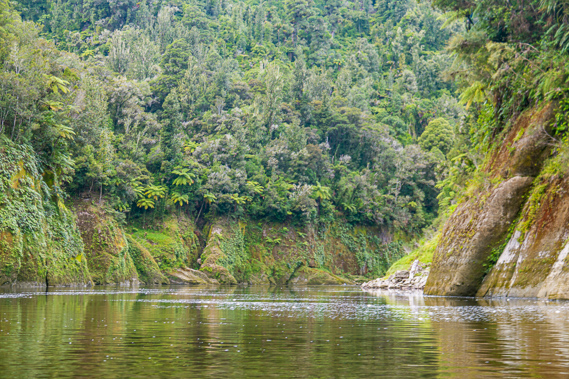
10:05 - From there the calm brown river turns sharply to the right. Around the back of the bend huge cracks cut away dark gullies leaving wedges of the harder rock exposed to the erosion of the river. The cliff on the inside of the bend moderate into a grassy slope with the remains of old trees lying on the shore and in the shallows. We keep to the left side of the river to avoid being snagged. The water becomes swifter with the surface slightly ruffled as we pass the Okateroa Rapid whilst the river straightens into a short reach. The hills close in very tight with the occasional pale brown scar of a landslide in between the pristine green forest above the erosion line and beautiful ferns and mosses covering the lower cliff faces. |
 |
10:06 - The valley widens a little turning the cliff faces into grass covered banks as we go through the almost non-existent Otaraiti Rapid through shallow waters from an old landslide. Upon passing the rapid, Cameron stopped and brings us together to share some of the chocolate that has been saved from the menu from the other day. Despite the summer warmth, the chocolate has remained intact throughout the journey without melting at all. |
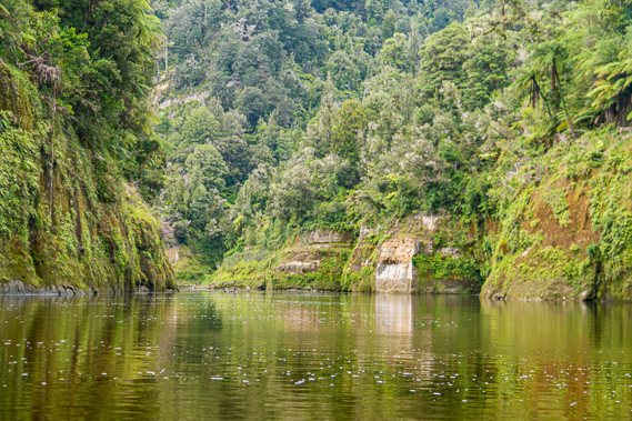 |
10:14 - The water is now mirror smooth as we start paddling again passing the steepening cliffs and narrowing valley towards the next bend only turning 12 degrees. We are about half way around the bend as we passed a small waterfall plunging about three metres down the cliff into the now murky water. Here we enter the Oapehu Rapid in the last part of the bend. There is a little gravel bank to the right from a small landslide as the flat water shallows towards a shingle bank to the left. At the end of the bend the river turns 60 degrees to the right entering the Otaipohata Rapid. There is almost no turbulence between the very rocky banks. |
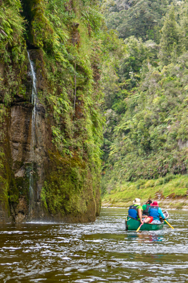 |
10:34 - We turn into another bend turning 60 degrees to the left. At the start of the bend is the end of a prominent ridge with an eight metre small waterfall tumbling out of the forest over the vertical mossy cliff into the water. The cliffs around the bend become more dramatic with exposed sections from landslides. In the middle of the bend is the Hautaua Rapid with almost no turbulence but a long shingle bank to the left. |
 |
10:41 - There is a short straight where the river widens and the the cliffs lower in response. This ends in a 30 degree turn to the left at the start of which we enter the Papakino Rapid. There are thick shingle banks to the right and rocks poking out of the water to the left. The swift water breaks over the rocks but the middle of the channel where we pass is fairly flat. The river turns into a short reach with another rapid visible at the end. The cliffs on the right hand bank are grassy with vertical columns of rock rising to the forest above. |
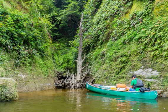 |
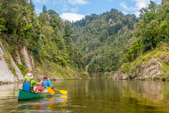
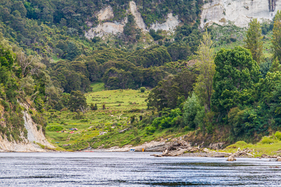
10:52 - About half way along the reach Cameron directs us into a small ravine where an old tree has come down roots first blocking the entrance beyond the first four metres. The roots are still mostly intact creating what would be a very difficult maze to get through. The brownish turquoise water quickly shallows towards the base of the tree under which a small stream bubbles out of the forest. We paddle into the ravine and raft up. Cameron explains the Mangapurua Landing is a short distance downstream. This is the start of the track heading to the Bridge to Nowhere. He explains there are two landing points on the rock. The better landing by far is reserved for the jet boats heading up from Pipiriki. Our landing point is going to be quite a difficult spot at the edge of the rock where we will need to climb out of our canoes and edge across the side of the mudstone. |
 |
11:10 - Cameron will have to go there first, climb out and secure his boat using his trusty rope. Then we will need to paddle there one at a time so he can secure our boats and get us safely to land. My boat remains in the tiny cove for quite some time whilst the other boats make their way to the landing. We occasionally poke out of the cove to see where the others are up to. Finally it is our turn. We paddle out of the ravine and head towards a light coloured exposed wedge of mudstone standing about four metres out of the water. The other canoes are tied up to it. We reach them and tie our canoe up to the side of the others before we climb over the other boats to the face off the rock. |
 |
11:16 - The rock has worn hand and foot holds which I need to sidle across heading up towards the top of the wedge. The holds are rather worn down as expected in soft mudstone but it isn’t too difficult despite having my camera swinging around my neck. It doesn’t take long at all to reach the ledge where everyone else is waiting. Looking down the rock ledge, the access from its bottom is very easy. There aren’t any jet boats hooked up to it. From there the river swings around a tight turn to the right, the is water up against the cliff face of ferns and mosses. On the other side of the river large boulders and snags rise up into a large plateau of long green grass. |
 |
11:19 - Aside from climbing up and down between the river and the camp grounds, and exploring the immediate camps, we have not done any walking at all on this trek. The entire journey has so far consisted of paddling 92.5 kilometres downstream by canoe, and will continue to be so for the remaining 31.5 kilometres to Pipiriki. Cameron ties the rope tied to all the canoes to a post. As he is doing so the couple who had stayed at our camping ground overnight paddles past. We ask them if they are coming up to the Bridge to Nowhere, but they want to continue paddling towards civilisation. |
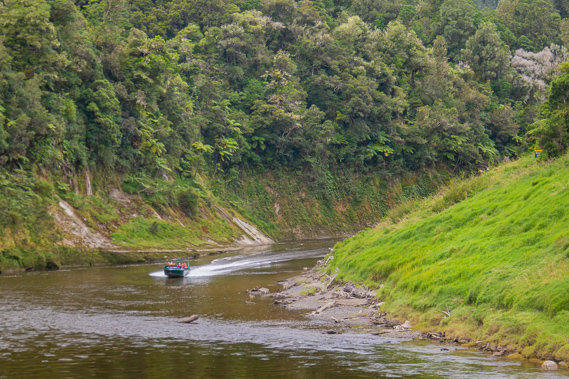 |
11:20 - A small green jet boat suddenly cames up the rapid at the corner and heads into the landing. We haven’t seen any for the past two days as they are normally not allowed between here and Whakahoro. I realise we will be encountering them quite a bit over the rest of today and tomorrow as they all come up from Pipiriki. We set off towards the start of the ledge at the top of the bluff before the approaching jet boat reaches the landing. |
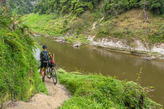 |
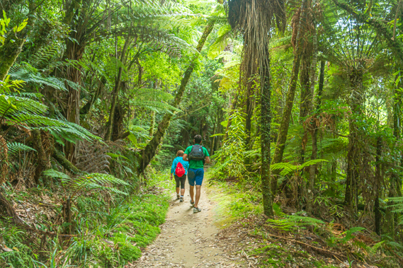
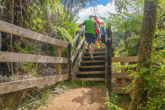
11:21 - The hike towards the Bridge to Nowhere provids a welcome break from paddling. Fortunately I am not stiff anymore, apart from my bony bottom which seems to start complaining from about ten kilometres into each leg of paddling. This morning we have only paddled 9 kilometres from Mangawaiiti and already I am sore. At the top of the ledge at the Mangapurua Landing, a well cut track ascends steeply over eroded steps in the soft mudstone to a gated entrance to the track at the treeline above the flood level. As we are passing the gate, a cyclist arrives coming the other way wheeling his rather muddy bike. Is this going to be a muddy track? |
 |
11:29 - The track we are now walking on forms part of the Mountains to Sea cycleway which starts in Ohakune and comes across the island to this point where cyclists are carried downstream by jet boat to Pipiriki from where they continue their journey to the coast along the Pipiriki Road down to Wanganui city. This track also forms part of the Te Araroa Trail covering 3001 kilometres between Cape Reinga at the top of the North Island to Stirling Point, Bluff at the bottom of the South Island. From the Tongariro Crossing, the Te Araroa Track heads down to the base of Mount Ruapehu before following the Mountains to Coast Cycleway to here. From here the official track requires a canoe ride from here down to Wanganui City, where the walkway continues just inland from the coast continuing towards Wellington. |
 |
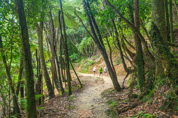
11:30 - Once through the gate the track becomes less steep as it enters the dark forest of ancient tree ferns and various native trees. We pass a large sign describing the aerial pest control operation to get rid of the stoats and possums and hopefully one day bring back the birds that have been so noticeably absent along the river. We pass another sign, this time a wooden one saying “Mathieson Roberts Ward” indicating someone’s plot of land. I didn’t expect to see any private land so deep in this remote rainforest. Just across the track from the sign is a dark shelter hidden in the forest. We stop here to take off our life jackets. Being on dry land mean we didn’t need them anymore. Cameron keeps his life jacket on though. It has his maps and info in its front pocket. Despite the overcast conditions, the air is warm enough to hike in a tee shirt. The shelter has a small picnic table which would have been good to sit around except there is a small track maintenance vehicle parked next to it.
|
 |
11:35 - As we are removing our life jackets, the group who landed by jet boat passed us. They are very clean looking tourists, certainly not as grubby as us having been exposed to three days and nights of the elements. A map on the shelter shows the Mangaupura Track heading from here roughly northward to the bridge, then eastward to the junction of the Kaiwhakauka Track which heads northwards to reach the river at Whakahoro 42.7 km away, or continue eastward to the end of the remote Rautiti Road 36 km away which goes south westward towards Ohakune. We leave the shelter following a board walk through the dense ferny forest. The board walk quickly ends in a long even dirt trail that would have at one stage been the road going from the mountains of the central plateau across to Taranaki. Heading from Raetihi. through the rugged hills of the King Country, it follows the Mangapurua River to its mouth near here and crossing over the Whanganui before continuing through the hills towards Taranaki. The road was built to just before the shelter, but never continued any further. |
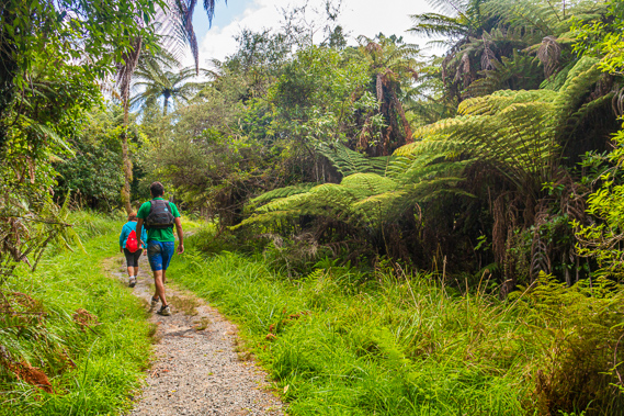 |
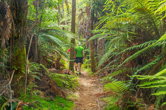
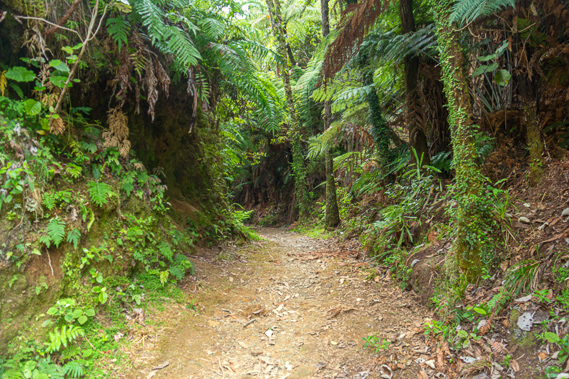
11:54 - One thing I quickly notice is although the forest is very dense, there is a distinct lack of large trees. There are none of the giant rimu, miro, totara or any other ancient trees towering above the river through the extensive forest we have travelled through over the past two days. In stark contrast the forest around here has only the small broad leaf varieties indicating it was once cleared through here and is now regenerating. The track is of a high standard, compacted concrete-hard from thousands of tourists and free of any mud. The forest of tree ferns is spectacular, broken only by a small landslide at the back of a small gully, but otherwise in excellent condition. |
 |
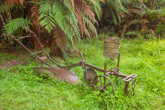
11:55 - The forest of mahoe has the occasional supplejack thicket in some of the gullies which creates an extra obstacle for hunters going off the track. Eventually the steep terrain moderates and the track becomes board walk over the ground ferns as it approaches the end of a spur. Parts of the track has flat roots growing across them, but they don’t create too much of an obstacle at all. Passing another small landslide the bush is just clear enough for me to realise we are heading up a valley, though I cannot see the Mangapurua River silently flowing far below. As we continue heading along the track the forest opens out to just tree ferns. A wide strip of bright green grass lines either side of the track as the terrain flattens. It suddenly becomes a small clearing with toilets up the gentle slope. Beside the track is an old plough, designed to be drawn by one to two horses. Several wooden signs are nailed to a stake. Each sign has a single word – Wynne, Hunter, Dust, and Morgan. These are the names of the farmers who settled in this area, similar to the other sign I had seen near the shelter. |
 |
11:58 - The Mangapurua Valley forms part of the half a million acre Waimarino Block extending eastwards from the Whanganui River between Taumarunui and Pipiriki to Mount Ruapehu. The block includes Raetihi and Ohakune. The government purchased the 44,839 acre block from the traditional Maori owners in 1886 in what is now considered an unfair deal. Once purchased the block was divided into smaller blocks to be given to the families of returning pakeha soldiers of World War I (1914-1918) following the passing of the Discharged Soldiers Settlement Act, 1915. This was part of a scheme in the late nineteenth to early twentieth centuries where the government sponsored the conversion of undeveloped forest into farmland. This was the last of the largest back country pioneering development schemes in New Zealand, known at the time as the Mangapurua Soldier Settlement. |
 |
12:00 - Upon their return from the other side of the world, the ANZACs would enter a ballot and would be allocated a block of land from various areas around New Zealand as a reward from the government for their service in the war. No doubt they would not have travelled to those areas, so they would not have any idea of what they had been given, apart from a piece of paper with the deed and a description of the location and boundaries of the property done by surveyors. The aim of the scheme was to help the soldiers to resettle back in New Zealand following the substantial interruption to their lives caused by the Great War. The government of the time promised they would return to a land fit for heroes. Unfortunately the scheme was only available to the Pakeha. The returning Maori soldiers could only watch in despair as their white counterparts were freely given the tribal lands their families had occupied for many generations. This was especially so here in Te Awa Tupua – the Sacred Whanganui River. |
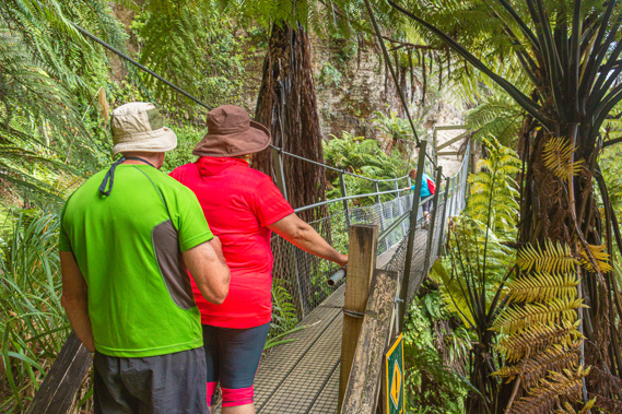 |
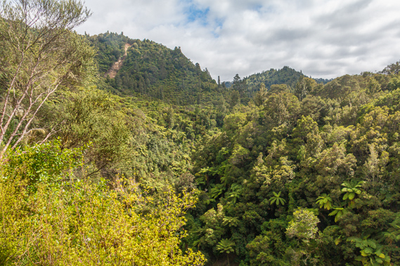
12:02 - From the clearing the track enters dense tree fern forest through a cut through the end of a small spur. Once through the cut the terrain suddenly steepens substantially giving some clear views of the towering hills. They are covered in scrubby bush from when they had been cleared. The cloud is beginning to break and the sun is starting to come out over the valley. Looking down are the almost vertical fern covered walls of the Mangapurua Valley with the river flowing quietly at its bottom. The track sidles along a ledge of hard rock where the slightly softer mudstone has been worn away. Ahead I can see a cliff face with almost horizontal layers. Upon reaching the base of the cliff the track suddenly ends at a well constructed swing bridge crossing the side of the ravine. The road must have slid down the hill at some stage. |
 |
12:08 - Once across the swing bridge we continue following the track through the scrub and tree ferns until eventually reaching a junction. A side track going up some stairs leads to a viewpoint just two minutes away according to the sign. The main track continues onto the Bridge to Nowhere. We take the stairs through the thick scrub passing another sign saying “Morgan”, obviously a continuation of Morgan’s block which had started at the clearing on the other side of the cliffs. The new landowners were likewise oblivious to what they were being allocated, being given their deeds by surveyors in their comfortable offices in Auckland or Wellington without ever having ventured in this part of the country. The settlers of the Mangapurua would have no doubt travelled by train up to the remote Ohakune before following the muddy forestry road to Raetihi. From there they would make their way through the forest firstly by road, then by almost non-existent walking track towards the valley through the increasingly rugged terrain. Very soon we were to discover why these eerie deserted hills became known as the valley of abandoned dreams. |
 |
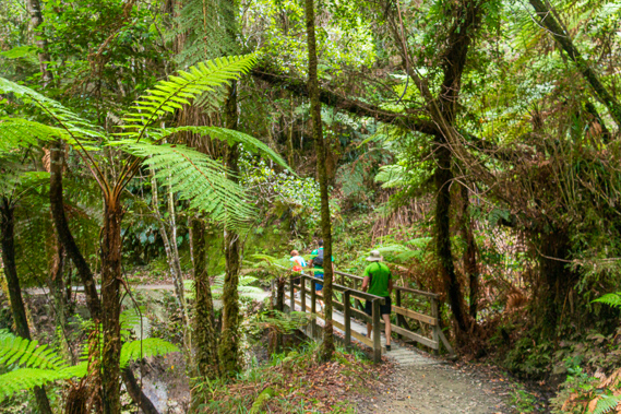
12:09 - The steps rising from the long abandoned farm level off into a narrow dirt track through the dense regenerating forest undergrowth before reaching a small wooden structure. Seven steps up the structure brings us to a tiny wooden platform just big enough to fit our group of seven. |
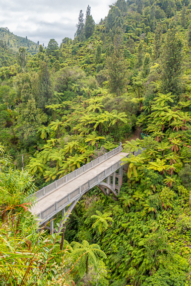 |
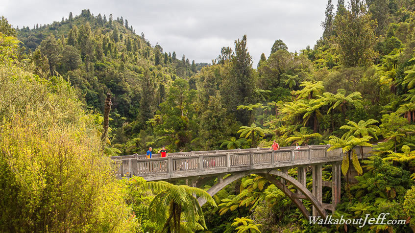
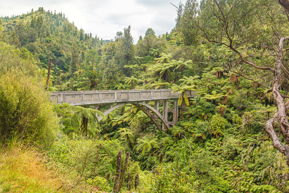
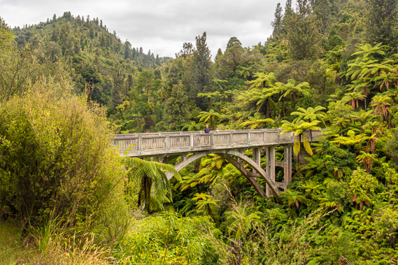
12:11 - Looking over the lookout into the steep gorge a concrete bridge spans the dark chasm surrounded by perfectly crowned tree ferns. It is a most unusual sight seeing the worn perfectly shaped concrete bridge here in the middle of the forest so far away from civilisation. This is the aptly named “Bridge to Nowhere”. On the far side of the bridge hidden under the tree ferns is the other group who have just arrived. |
 |
12:17 - Looking out from the platform, decades of regeneration had created a forest of tree ferns and small trees now covering the steep sides of the valley above the deep gorge. I imagine the fifty four families who settled here would have been a bit shocked to see how difficult this terrain was. With no road access at the time, they were very much on their own. The first arrivals had to cross the Mangapurua Stream by scrambling up and down the precipitous walls of the gorge. With little reference or surveying knowledge, the settlers tried the best they could to find their plots using their survey plans. Some got it wrong and ended up clearing the wrong section of land, much to the joy of the real land owner when disputes were settled by visiting surveyors. Despite the remoteness and conditions, most of the settlers built their own houses, firstly out of tree fern logs, then eventually from sawn timber of the huge trees they felled when clearing their land. Each house was accompanied by a garden and a small cow shed for milking the house cow. Supplies were delivered to the valley by packhorse and sledge over the precarious road. The families had to improvise as much as they could. The Wairoa was in service during those years so most of the supplies came in by river to Mangapurua Landing before being hauled up the track we had just followed. |
 |
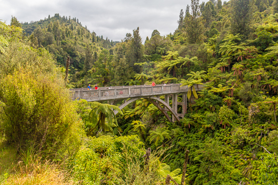
12:18 - From the lookout we return along the track to the junction before continuing along the main track towards the bridge. There is an excellent viewpoint about fifty metres short of the bridge. From here I can see the bridge is sitting on a nice parabolic arch spanning the river far below. We walk the final short section of track which curved into its entrance as would be expected in a road. The concrete bridge is still in very good condition, but its texture is very rough from decades of erosion. The families settling here vowed to stay here on the condition that the Raetihi to Stratford road would be built providing good access to the area. In the interim they would persevere to establish their farms. Looking the other side from the bridge the stream formed a long deep pool before disappearing as the river wiggled before turning in front of the cliff face we had crossed by swing bridge earlier. From here the terrain looked even more rugged than it had felt walking through the tree ferns. The early settlers must have faced an enormously daunting task to clear their block and convert it to grassy fields to farm on. It was a lot of work clearing the podocarp forest and clearing back the scrub to create grassy paddocks. |
 |
12:21 - At the entrance of the bridge we met Winston, a well tanned Maori guide who drove the jet boat we had seen earlier and was leading the other group. Looking upstream from the middle of the bridge I can see a wire crossing the precarious ravine with several pieces of metal hanging off it. This was the remains of Morgan’s Bridge, a swing bridge that was erected here in 1919 to serve the initial settlers before the main bridge was built. It was never dismantled but the wood making up the flooring and sides has long rotted away. The cables have remained here for over a century to decay. Far below the remains of the swing bridge the stream quietly flows in a straight line deep in the bottom of the ravine.
|
 |
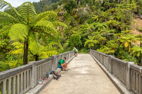
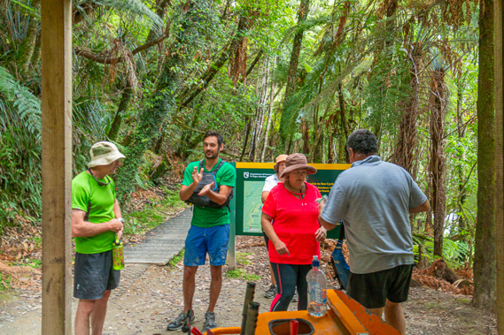
12:27 - A school was built and despite its remoteness the valley prospered even before the bridge was built. At the far end of the bridge are a couple of picnic tables and a large sign, all obscured by the huge fronds of the mamaku black tree fern. Our group relaxes on the bridge. We had some individual photos taken on the bridge taken from a point 50 metres back down the road before Winston began a presentation from by the picnic tables, starting with telling us that he had been here working on the river for five generations.
|
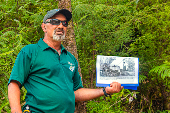 |
12:36 - I am wondering if Cameron had deliberately timed our departure at Mangawaiiti and our arrival and Mangapurua Landing to coincide with Winston’s presentation. Winston has a blue A4 book with clear plastic sleeves full of pages of old photos which he goes through covering the history of the area, and some of the stories of how tough it was settling here. He describes how the small group of one engineer and three apprentices put together the bridge in such difficult circumstances at about the same time as the “Bridge to Somewhere” was constructed. It was built by Raetihi firm Standford and Brown for the Public Works Department between January 1935 and June 1936. 105 cubic metres of concrete was used to build the bridge. All of it had to be packed in along the difficult track from Raetihi. The delivery costs of 419 pounds, 14 shillings were almost as much as the construction costs of 598 pounds, 11 shillings, 7 pence. There is no record of the cost of materials. The gravel used for the concrete was carted from the Rangitikei River. Four people built the entire bridge in just eighteen months, but records note delays in the construction due to floods and slips causing delays in the arrival of materials. The 34 metre long reinforced concrete arch bridge was built about 40 metres above the stream. The bridge was completed and opened in June 1936, twenty years after the first settlers arrived in the valley. This provided continuous access from Mangapurua Landing to Raetihi, now the favoured way in and out of the valley over the paddle steamers of the river. Both bridges were to be part of a road connecting Raetihi. to the Whanganui River at Mangapurua Landing and crossing over to continue to Stratford at the end of the Forgotten World Highway at the base of Mount Taranaki.
|
 |
12:48 - Just past the picnic tables on the other side of the bridge the track continues entering the bush through a dark cutting heading towards Whakahoro and Ohakune. The track follows the old road which had been difficult to maintain on the unstable land continuously prone to slipping. As the bridge was being constructed the settlers here realised how difficult it was working this rough country, and those who had succeeded in clearing the bush quickly realised how poor the soil is here. This was exacerbated by the global depression of the early 1930s, with prices plummeting causing the area to fall into economic hardship. One by one the families walked away from their land and the close-knit community they had built. By the time the bridge was completed only three families remaind. A big storm in January 1942 created a large landslide wiping out parts of the road, including the slip we had crossed by wooden swing bridge. The steam boats had stopped running on the Whanganui River several years earlier, so with no support, the remaining three families were ordered out by the government abandoning their lots having worked hard for over twenty years with nothing to show for it, apart from 250 pounds of compensation. In today’s figures that was about $21,600 cash or enough to purchase $123,200 of housing.
|
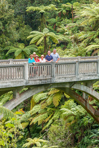 |
12:49 - All that remains of the failed settlement is the bridge, a walking track along the disappearing road line, old fences, a few stands of exotic trees, a few crumbling chimneys, and of course the Bridge to Nowhere, now one of the best preserved ferro concrete bridges from the 1930s. Once the presentation is finished, the other group returns to the landing keeping the bridge free, so Cameron collects our cameras and takes them to the view point to photograph our group. We get our shots done just before another sizeable group arrives looking fresh and clean no doubt having come up the river this morning by jet boat.
|
 |
12:50 - Heading back along the Mangapurua Track I have one last view of the bridge which now has quite a few brightly coloured jet boat tourists on it. The sun is coming out again, so we have timed our arrival very well, with perfect lighting just before the arrival of the middle of the day hoards of tourists. We amble our way back along the track quickly returning down the very gradual descent towards the shelter. Just before the shelter we pass another group of canoeists who would have come down from John Coull this morning, led by a young lady from Canada who Cameron seemed to know – probably another regular guide from one of the other companies.
|
 |
13:17 - From there we continue our 2.7 kilometre return walk to Mangapurua. The valley stands representing the closing stages of the pioneering era of New Zealand. The country was occupied by free settlers from the other side of the world. This was one of the last areas of New Zealand to be settled, but the remoteness and ruggedness of this area will ensure it will never be viable.
|
 |
13:28 - We reach the shelter and collect our life jackets, each of us remembering exactly where we had put our so we keep the same jackets as in the rest of the trip. From the shelter we follow the steep track down to the gate, then onto the large slab landing. The green jet boat that had taken the other group is still loading its occupants back on board. Tied up to the railing over the back of the boat is the muddy bike that we had seen upon starting the walk. The cyclist had arrived here two hours early but will finally be on his way back to Pipiriki. Next to the green boat is a slightly larger yellow jet boat with a few life jackets strewn over the seats. Its occupants would have been the group that had arrived at the bridge just as we were leaving it. The income from tourism and ongoing conservation efforts will ensure the Bridge to Nowhere will remain standing in its totally non-functional location for many years to come, standing as a solitary reminder of the tough ANZACS who spend up to two decades doing the best they could establishing their farms on this most unsuitable location in this valley of abandoned dreams.
|
 |
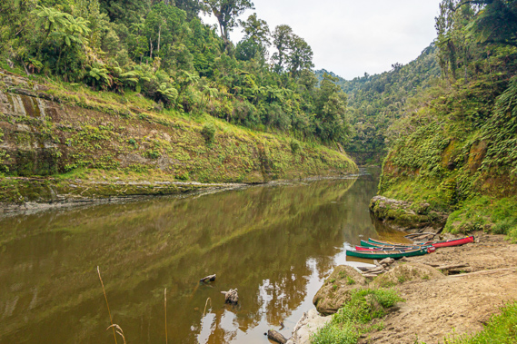
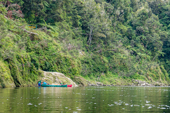
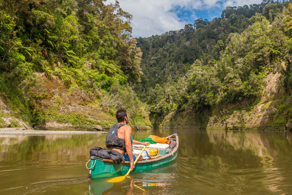
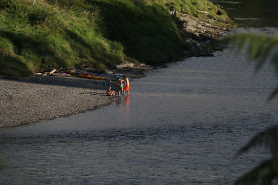
13:32 - In between the boats is a string of canoes and kayaks the other group we had passed have left here. There are another one or two canoes and kayaks alongside the landing near our boats. We need to go down the rock climb back to our boats, with my boat first as it is at the far end. One by one the boats will have to be cast off, so Cameron tells us to head down the rapid and stop at the gravel beach on the other side to wait for the others. The climb down to the canoes is a little precarious but there are reasonably firm hand and foot holds, keeping three points of contact on the rock wall as one is supposed to whilst climbing. The green jet boat takes off down the river as we take our seats in our canoe.
|
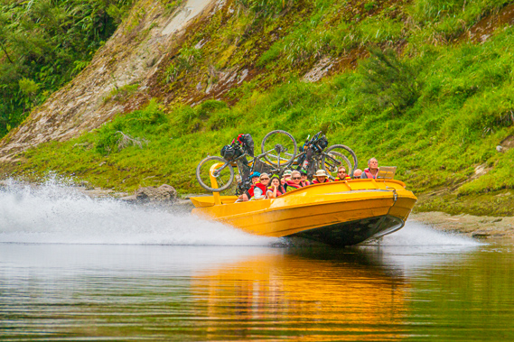 |
14:16 - I thread the precious rope from the bow of our boat and throw the end back up to Cameron to set us free and for the others to come on board. We push off backwards towards the middle of the river before working out the rapid ahead of us. Normally we have Cameron to follow, but as we are out in front we have to work this out alone. The water runs quite hard up against the rocky cliff around the back of the sharp bend. From there it gradually shallows towards the gravel bank on the other side. We steer our way into the vee of the Mangapurua Rapid at the shingly mouth of the river coming through a narrow ravine. We keep away from the wall and cross the eddy at the other end to the rocky beach, where we land and pull the boat ashore whilst waiting for the others. A short distance downstream two young guys have landed having lunch. Another yellow jet boat powers upstream towards the rapid, staying on the plane whilst shooting up the swift water with ease. Once the jet boat clears, the others come down the rapid with ease and join us, followed a couple of minutes later by Cameron paddling down as we all watch on. Once he arrivs we organised lunch. Despite having been on the water for serveral days, the fresh salad vegetables has kept fine in the chilli bins as we make our wraps for lunch. The yellow jet boat powers past carrying eight passengers and three bikes. Another cycling group must have arrived just after we had left, making it just in time to catch their boat. The tyres were muddy, but the bikes weren’t as muddy as the other bike we had seen earlier today. The boat zooms down the rapid heading quickly towards Pipiriki where the cyclists will continue on their ride towards the sea at Wanganui.
|
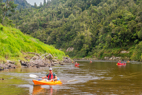 |
14:22 - There are quite a few wasps around, no doubt from the nearby camping ground. The Mangapurua camping ground is just up the grassy bank. It doesn’t have anywhere near the character of the camping grounds we have stayed at over the past couple of days, but it is a good place to stay the night after a late afternoon trip to the bridge, or for those strong enough to paddle against the current of the shallow water next to the rapid for a very early morning start to the bridge. The group we have passed towards the shelter on the track arrives here as we were packing lunch. Their group has four kayaks and a canoe. We have not seen any kayaks before now. They stop near us for lunch before heading onto Tieke Kainga later today. We set ourselves adrift into the small eddy and head onward downstream. From here we have ten kilometres to head downstream to Tieke Kainga, and 31.5 to Pipiriki. We are still 120 kilometres upstream from Wanganui.
|
 |
14:47 - We are now in the busy part of the river, joined by lots of jet boats taking the tourists up and down to the Bridge to Nowhere from Pipiriki. The river is busier now than it had been at the peak of the steam boat era in the early twentieth century when 12,000 tourists would journey along the river per year, but they would have travelled on only a few boats per day. At the time around three thousand Maori people were living along the river, their villages dotted amongst the precipitous terrain were amongst the main attractions. The river became known as the Rhine of New Zealand. These days most tourists are travelling by small jet boat, and with more people than ever, this means lots of jet boats on the river, navigating their way up and down the most challenging navigable river in the world reaching speeds of up to 70 kilometres per hour.
|
 |
14:51 - From here this means we have to be on the lookout for jet boats, and head to the right bank turning towards the middle of the river so they can quickly pass and we can comfortably ride their wakes. Loaded jet boats take quite a lot of power to reach their planing speed, so best we give way to them. Looking downstream the valley is beginning to widen with the cliffs now no more than steep banks. We are heading down the other side of the narrow horseshoe strip of land under what would have been the continuation of the road from the bridge over the river winding its way uphill towards a saddle on its journey across towards Taranaki. In the distance is the 447 metre high Otikoki Hill where the river starts narrowing and the high forest beings clearing marking the start of the Tangahoe Farm.
|
 |
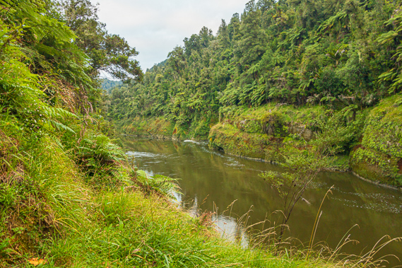
14:51 - The water is a chocolate brown colour probably from all the sediment still suspended in the Tangarakau, Whangamomona and now the Mangapurua Rivers. Fortunately there are no snags like there had been downstream from the mouths of the other rivers even though the Mangapurua Valley had at one stage almost completely been cleared. About half way along the reach we enter the Opopo Rapid where large rocks on either side of us create quite a bit of turbulence but along the left side where we headed was reasonably smooth. The river narrows and parts of the mossy cliff has been stripped into large patches of exposed layered mudstone. As we reach the end of the bend we enter the very small and quiet Oparia Rapid. The cliffs to the left are quite spectacular in being very irregular with deep crevices carved into them and fern covered spurs jutting out a little into the water. The largest canoe ever used on the river was carved at the top of these cliffs. The great Tauwharepuru was big enough to hold a hundred Maori warriors. It was lowered from the top of the cliff using ropes made from the supplejack vine. It must have been an enormous effort to lower such a large boat down these cliffs.
|
 |
15:23 - Once below the rapid, there is a mineral spring staining the papa clay black. Unlike other springs we had passed earlier in the trip, this is a sulphur spring fed by some crack in the ground going deep to the volcanic zone. Just downstream from the spring as the river starts to gradually turn to the left about ninety degrees is a new unnamed rapid created during the winter of 1991 when a slip came down blocking the left half of the river. The landslide deposited a lot of rocks and trees into the river with rocks to the left and tree remains to the right creating some turbulence as we pass it. This is shortly followed by the Aoporo Stream coming in to the right down a valley between two low hills. The end of the stream is a delta shaped grass bank with a dead tree still standing up in the middle of it.
|
 |
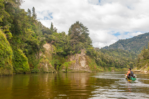
15:40 - The valley once more opens up substantially as my behind starts getting sore again. The river makes a sudden twenty degree turn to the left passing through the Tangahoe Rapid through a small log jam on either side. Otherwise it is a very minor rapid passing the Tangahoe Landing. This marks the start of the first farmland we have passed since just before Maharanui, and also the tribal boundary of the Ngati Maru ki Taranaki iwi which we have been following since the Tangarakau River. The territory sweeps westward encompassing much of the Forgotten World Highway up to Stratford. From here we are passing through the tribal lands of the lower river tribe of the Te Ati Haunui-a Paparangi. It is a very rugged farm to our right being covered mostly in scattered scrub over long grass with a rough track heading up from the landing to the farm. From here the valley continues to open. We haven’t seen it this open since Ohura. We are now out of the upper gorge. We reach the end of the straight and enter a sweeping one hundred degree turn to the right. At the start of the bend we reach a large landslide to the right with shingle banks and boulders creating minor turbulence over the Tokatapu Rapid.
|
 |
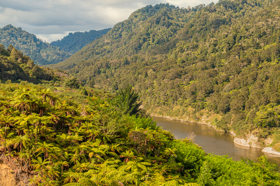
15:49 - The gorge continues to open to nearly as broad as it had been at Taumarunui as we pass the 100 kilometre mark since leaving Ohinepane. To the left we pass the Mangatiti Stream and its landing next to it. A rough track leads up the valley about eight kilometres to a remote farm at the end of the Mangatiti Road, a dirt road going over the rugged hills from Raetihi. We are just two kilometres short of our stop at Ramanui. By now the entire right hand valley is clear. As we continue around the bend a large cliff face of mudstone appears at the end of the reach. It stands under quite a high range marking the sudden end of the relatively open valley. There are plenty of trees around, but it was obvious this is a reasonable farming area. Another jet boat quickly approaches so once more we headed to the right hand side to let it pass. When we reach the end of the bend we pass some large exposed eroding cliffs to the left and around a huge tree in the right hand side of the river creating shallow banks as we pass over the Otaiko Rapid. This was once quite a notorious rapid but this was fixed in 1910 when a 100 metre long stone wall was erected to deepen the water. As we pass through the the rapid we could see a number of buildings of the Tieke Kainga area, where we are destined for tonight. There is a small kink in the straight where we enter the Aritini Rapid with a little turbulence in the middle of the river but a lot more in the shallow waters of the left and lots of rocks and logs to the right. It seem the river has broken to pieces in this area where the land has been cleared and eroded. The turbulence to the left suddenly passes into a large eddy which we safely evade.
|
 |
15:53 - Looking ahead I can just make out a number of canoes that had been beached and more on the grass further up the hill. There is still little sign of any buildings, but they must be hiding in amongst the large exotic trees, including poplars and other varieties that obviously don’t belong to the native forest we have been travelling through over the past three days. The right hand bank is littered with the dead remains of huge trees. We pass another kink in the straight going into the short turbulent channel of the Pouwhawha Rapid around a particularly big log jam across the left half of the river, and passing a large rocky outcrop to the right. The outcrop marks the start of a long shingle bank running along the log strewn bottom of the grassy hill.
|
 |
15:54 - There is a small clearing in the log jam to the right marking the Parinui Landing, named after the farm above it. This is the second of four farms along this section of the river. It has been farmed for around a hundred years and a school had been set up above the landing for the children of these farms in Parinui and Ramanui until it closed in 1940. Past the landing the log jam to the right intensifies under a low cliff going under Ramanui. The water remains fairly calm for a couple of minutes before we enter the Ramanui Rapid just before the start of a ninety degree bend to the left. We follow Cameron down the rapid passing a large log jam to the right before turning into the eddy just below it to land at the Ramanui Landing.
|
 |
16:07 - This is a fairly big rapid, so we have to concentrate hard to pass the log jam before heading across the eddy to the landing spot. If we miss it we will keep going down the next rapid towards the lower gorge around the corner, drifting down towards Pipiriki. We paddle hard towards the landing, all successfully negotiating our way around the rapid to land. We pull our canoes up between the rubble of the log jam, having completed just 16 rapids today.
|
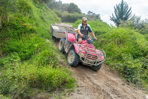 |
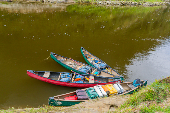
16:08 - Parked on the dirty shingle bank in front of us is a quad bike and a trailer. This is the first land vehicle we have seen since our van at Ohinepane. Following several days of isolation, this seems a most odd sight. The driver is an old fellow named Derek, who works here at the Ramanui Farm. We unpack the canoes and loaded all the drums onto the trailer. I suddenly realise there was going to be no more lugging of these awkward drums up and down the muddy slopes. Derek’s quad bike is going to do the work for us. We load the bike with half of our supplies before he straps everything in and rides up the dizzyingly steep hill to disappear for a few minutes whilst we finish unpacking the canoes. Cameron tied the canoes to a sturdy log with his trustee rope. Eventually Derek returns dropping down the insanely steep slope back onto the gravel bank. He starts loading the rest of our gear as we puff our way up the hill towards the camping ground. Once on top of the initial rise, the four wheel drive track split into two heading up the hill. We follow one of the tracks before it joined up again in another single land dirt road heading off in either direction. We follow the track to the right.
|
 |
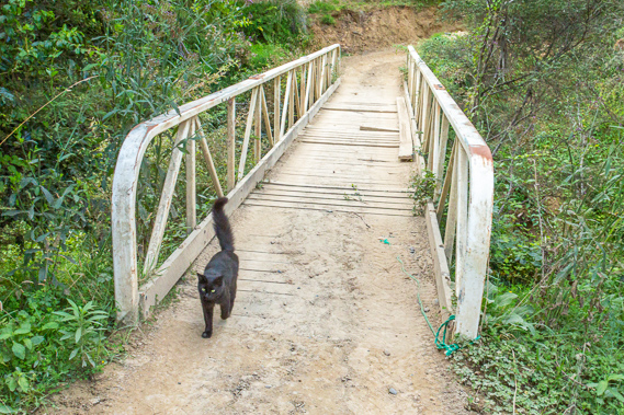
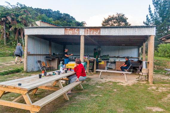
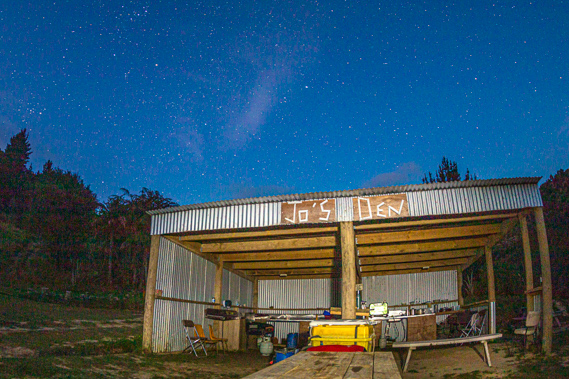
16:28 - The track passes a very rustic picnic area. The setting is such that you would expect farm animals like sheep or cows to wander through, but the only animal here is a very friendly black cat surprisingly keen to see us. We walk along the dirt road above the river heading upstream for a couple of minutes before the terrace widens into a large clearing in the hill. In the middle of the clearing is a big corrugated iron shed with the front open serving as a shelter kitchen. There are a couple of picnic tables inside the shelter and a few more outside. The shed has a rustic sign saying “Jo’s Den”. Derek arrives in his quad bike and we unload it. He told us not to let the cat into any of the huts and in his farmer gruff voice told us to kick it out of the way if needed. Surrounding the shed were several small huts. These are going to be our accommodation tonight. No other groups have booked these huts, so we had the entire complex to ourselves.
|
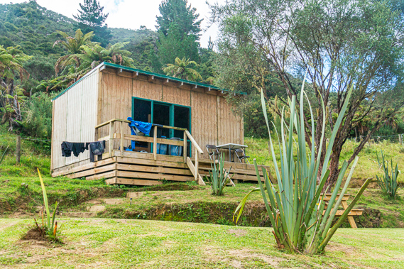 |
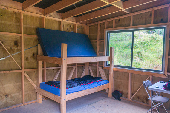
16:34 - The hut has a nice verandah with a couple of chairs on it. A ranch slider leads into the hut where three bunk beds are set up in the rather basic hut. Aside from the ranch slider there is a window at the right hand end of the room with a table under it. I take the bottom bunk near the window. Although the hut is fully clad and closed in from the outside, there is no cladding inside exposing all the framework. The black cat sits on the porch attempting to come in whenever we open the door. Finally it gives up and heads to one of the other huts. Outside the hut is a washing line string where we hang our clothes from the river today. There are flush toilets and a couple of showers a short distance down the hill. It is great having the first hot shower since Ohakune. It is a very basic set-up with the heating source some distance away and the building being an open wooden structure, but the bright patterned plastic curtain providing total privacy.
|
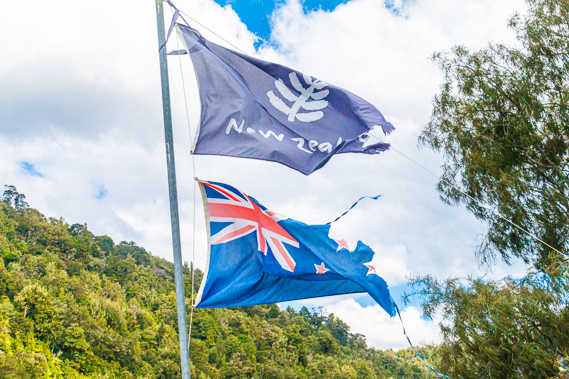 |
16:37 - Once all washed and relaxed, we return to Jo’s Den and meet up. Cameron mentions a lodge up the road, so we all walk back along the road. We pass the junction to the steep tracks to the river and enter the kanuka scrub. Just before the scrub we pass a flagpole with the shredded remains of the silver fern and New Zealand flags. |
 |
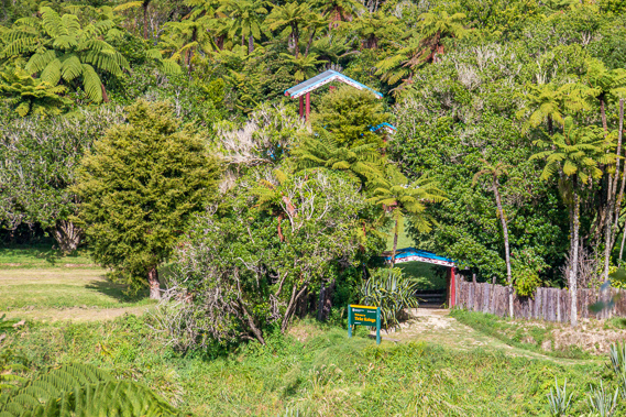
16:38 - The black cat follows us as we start heading uphill towards the Bridge to Nowhere Lodge. We cross a bridge over a very scrubby gully. After the bridge the track rises, heading up the hill, turning off on a steep stairway alongside a fence to the top of a small terrace where the spectacular lodge sat proud. The lodge sits atop a small knoll in the ridge, beyond which is a wide gully of pasture under the high ridge of the Matemateonga Range. The ridge is known to the local Maori as Whakaihuwaka meaning “made like the prow of a canoe” as its shape does remarkably resemble an upturned canoe.
|
 |
16:42 - The late afternoon sun is shining very brightly now, creating a spectacular effect when shining through the prehistoric tree fern fronds. Shade is already covering most of the width of the river and the temperature is beginning to drop. Looking through a gap in the tree ferns a terrace appears above the other side of the river where the bush has been cleared into a large flat grassy area. There are several small buildings in the scrub around the trees. The eaves have obvious Maori carvings on them. This is the Tieke Kainga Marae. The DOC camping ground is around this area. It is one of the few Maori villages still in existence on the river. There seems to be very little activity there today, so maybe the locals are away for the day. Tieke Kainga is an old Maori village named after the New Zealand saddleback, a once very common bird with black glossy plumage and a chestnut red back. They have orange red wattles at the base of their black bills. Like many species, they are all but extinct now on the mainland but I have seen them down south on Stewart Island. Tieke was often visited by the passing missionaries in the early days of European settlement in this area. They reported many fruit trees grew here. It was an important trading centre on the river, being nearly half way between the mouth and Taumarunui. It was also a fortified pa and a place of learning with around 80 to 90 inhabitants at the time.
|
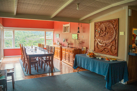 |
16:46 - The family owning the Bridge to Nowhere Lodge have been based here at Ramanui farm since 1951, but for many years the homestead was only a small cottage. The family sold the 1500 acre farm, but 26 years later their teenage nephew bought it back and built the lodge. With no road access, all the materials used to build and supply the lodge had to be brought in by jet boat. The lodge now has seven bedrooms to accommodate up to twenty people. More recently they have expanded the accommodation to respond to the increasing tourism in the area by building the four cabins, a camping ground, and the cooking area where we were staying. There are a surprising number of people staying at the lodge, mostly perhaps from the jet boats. In the solitude of our journey down the river, we have seen very few people before reaching Mangapurua this morning. Some of the people staying here were those we had seen canoeing along the river today, but they were all staying in one of the local camping grounds on either side of the river. From the lodge's deck we have a spectacular view along the river meandering its way through the forested triangular hills. The Tieke Kainga camp ground and marae are obscured by several huge poplar trees. Perhaps this is deliberate to ensure the view from the marae is absolutely pristine.
|
 |
16:52 - Looking beyond our camp ground past the huge planted pine trees is the Parinui farm, which used to be a large kainga on the hill a hundred metres above the river called Utapu which co-existed with the Pakeha settlement at Ramanui with still having a population of around a hundred people in 1928. The village was the main settlement of the Ngati Ruru tribe – the bush owls. It was named after Rauru Kitahi, a Maori warrior who settled in the south Taranaki area after extensively travelling all over the country. Although the villagers were based on the hill, they would have been part nomadic like most of the other tribes along the river. They would move up and down the river with the seasons. They would stay here during spring during the time of planting. During summer many would head downstream to the river’s mouth for fishing. Autumn they would return upstream to take the eel and lamprey, and return to the farms for harvesting, collecting berries, and for storing food for the winter. The tribes had an elaborate calendar, the kaingas working with each other under tight unwritten fishing codes to ensure the resources of the river were shared peacefully to maintain stocks and to keep the water pure. The crystal clear waters of bygone days demonstrated their avoidance of appearing greedy or disrespectful to the gods.
|
 |
17:30 - We meet the group that had arrived at our lunch spot, and Cameron talked to the American lady he seemed to know. She mentions the couple we had stayed with the first night had arrived here yesterday and liked the lodge so much they enquired about working here. I’m not sure if anything came of that though. They had moved on downstream this morning. A yellow jet boat is hurrying along the water out of the gorge and up the rapid with ease. It continus heading up the river for a late afternoon tour of the Bridge to Nowhere. By now the sun has almost completely come out, so it won’t look quite so tranquil as it had done this morning when we were there. The black cat hangs around us as we relax in the deck chairs. With no tents to sleep in tonight we all know we are in for a good sleep.
|
 |
17:58 - In the pre-European days the Maori saw the river as a paradise saying they could hear it talking to the trees and birds. They lived very well at one with the river. Special places along the river were dedicated for bathing, other places for religious ceremonies. The caught fish were removed from the river for processing and disposal away from the waterways in special middens. All waste was deposited in the soil away from the river to keep it pure. Today it is very different with the noisy boats tearing up and down the river delivering tourists to their destinations, and with the modern pakeha lodge and camping areas for people to stay. The waters of the river are somewhat muddied by the farming activities upstream, and the birds of the land were all but gone with the prevalence of stoats and other predators eating their eggs. The villagers of Tieke Kainga lived in peace until the sudden Waimarino purchase in 1887. Following the purchase of the block, the chief Te Ranihuatau asserted it was still Maori land even though the New Zealand government considered it “crown lands upon which the natives are allowed to use and occupy without a title”. In 1906 the village changed ownership from the tribe to the government. Unfortunately all records of the transaction have been lost. Two years later Chief Te Ranihuatau died and the remaining tribes people abandoned the marae. With the people gone the government set aside the land as a scenic reserve, ensuring development will never happen. |
 |
18:05 - With the sun still high, we return to our huts around Jo’s Den. The black cat follows us once more down the steps to the dirt road ensuring our safe return to the huts. Most of the way back I find another shelter kitchen hut for when there are two big groups here. The hut has a large topographical map and a large noticeboard pointing out the different areas around here. Opposite the hut is an outdoor wash basin and two picnic tables under shelters made from the rough logs of tree ferns. I look across to the other side of the river where several people are carrying their gear up to the camping ground. They have arrived quite late, so I assumedthey had come from John Coull today and had done the Bridge to Nowhere hike. |
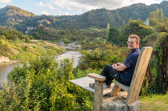 |
18:10 - Upon our return Cameron starts preparing dinner whilst the rest of us relax. Near the shelter is a large wooden seat. It looks terribly uncomfortable but was a very good fit with a small table for drinks. The seat looked over the river and the small peninsula terrace that Tieke Kainga sat on. Three canoes are beached on the stony beach and three people are swimming in the river. From the canoes a dirt track rises moderately along the slope to the terrace where I can see the camping ground with a couple of picnic tables on the lower terrace below the entrance of the marae. A couple of buildings of the marae are just visible through the trees but it is mostly obscured from the spectacular valley view. We all have goes at sitting on the seat and admiring the view looking downstream along the start of the last leg towards where we were heading tomorrow. From the chair I can see upstream but the view is blocked by a couple of old pine trees.
|
 |
18:26 - The river was an ancestral treasure handed down from generation to generation, not a commodity to be bought, used and disposed of. Each of the 143 marae settlements along the river had its own taniwha watching over it as the guardians and protectors of the river and its people. The taniwha punished those entering the area with hostile or disrespectful intents. The Aitehaunui-a-Paparangi people have been laying claims to the river in a number of petitions to the New Zealand Parliament since 1887 after the King Country was established and land sold. In recent decades they have been seeking compensation for the gravel extracted from the riverbed, and for the diverting of water into the Tongariro Power Scheme. In September 1993, following over a century of little progress, a group of local Whanau o Tieke Maori travelled upstream from Wanganui by jet boat to occupy the hiking hut at Tieke which the Department of Conservation had built not long after the national park had been declared in 1986. The hut didn’t cause much controversy until 1993 when the Department of Conservation started to levy a facilities use pass as a user-pays method of maintaining the huts and services. This caused an uproar amongst some of the Maori people leading to the occupation of the hut. They converted the hut into a small meeting house, erecting carvings at the front, and converting the bunk rooms. They continue to occupy the hut to this day to assert their land rights. In the years following the initial occupation, the original camp ground has been converted to a fully functional marae with outdoor seating and a pou (carved wooden post) in the middle. Formal deed of the land was finally signed off in 2003, which included thirty one million dollars compensation to the tribe for the damages done by the government.
|
 |
19:19 - The sun goes behind the ridge causing the temperature to drop. Dinner is nearly ready and Cameron brings out some large pots with the food he has been cooking. He has done a spectacular job with cooking up till now and tonight is certainly no exception. This is our final dinner together so he wants to make it a good one. |
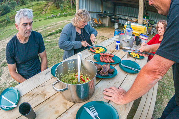 |
19:29 - As usual he cooks too much food, but we need it with having paddled over a hundred kilometres over the past four days. There are steaks, sausages, curried potatoes, kumara, carrots, peas and salad. The sun set somewhere on the other side of Mount Taranaki which has been elusive from the deep valleys. The sun lights the small remnants of cloud a caramel orange colour. The sky is starting to draw dark, and several people who have been drinking at the lodge paddle their canoes back to Tieke Kainga for the night. With no civilised street lighting here and the legends of the taniwha strong here, they need to cross the rapid whilst it was still light. Lemon cake and cream makes for a nice dessert. |
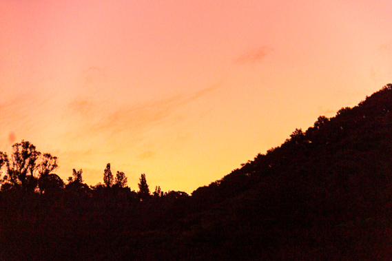 |
20:29 - The sky is quickly getting dark, so we light a couple of candles in the shelter and wash up. It is almost completely dark and there are still a few people paddling back across the river from the lodge to the camp ground. By now the western sky is a purple colour merging to pink and yellow in the direction of the set sun with the final light of the evening twilight. The bright stars were coming out. |
 |
21:09 - It is now a few days after the full moon, so there is a chance to photograph the bright starry sky. We are a long way from any light pollution, so this is a great place to capture some stars. I want to save battery power though, so decide against doing any star fields. The others all head off to bed but I remain up for a while getting some night shots of the stars and the river before the moon comes up. I feel a presence next to me. The black cat is purring and rubbing itself on the picnic table where I have set up the camera. Cats don’t seem to understand the concept of photography. With one more day on the river, I need to turn in for the night, and make the most of sleeping in a bed tonight whilst across the river, Tieke Kainga continues to quietly pull its political influence on the river.
|
|