--- Archive files ---
Home > Treks > Inca Trail > Day 3 > 3.2 |
The Gate and the Swingbridge
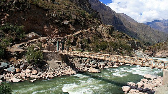
JUST ahead of us the track stopped at the entrance of a thatched steep roof hut. A large wooden swing bridge crossed the river to the left from the hut. The trail then steeply ascended across the rock face on the other side. The hut was the checkpoint where we would get our passes. A large blue sign appeared on the gable of the hut saying:
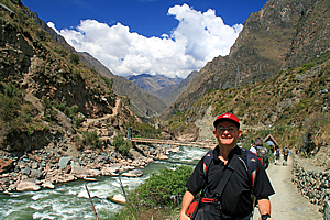
Near the gate entrance of the trail |
Santuario Historico de Machupicchu
Patrimonio Cultural de la Humkanidad
RED DE CAMINOS INCA
Bienvenido – Welcome – Bienvenu
Control Piskacucho Km 82 – Inicio del Camino Inka
Although most people considered this to be the start of the Inca Trail, we were actually eighty two kilometres along the original trail. The trail started in Cuzco, the ancient Incan Capital. In Incan times, all roads throughout the empire led from Cuzco. The trail we were walking on would follow the final forty six kilometre path towards the Incan emperor’s retreat in Machu Picchu.
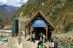
The gate |
When my travel agent organised the registration of my Inca Trail pass ten months ago, I still had my old passport. That had become water damaged during the South East Asia and Borneo trips so I got a new one before this trip. The new passport had a different number on it, and the people who register the trekkers use the passport numbers at the time of booking. As a safeguard at the advice of my travel agent, I had photocopied my old passport before surrendering it. Now I was the only one in the group with this situation, so Wilbur let me through the hut at the track entrance first. He said some inspectors were okay, but others may be a bit anal about the change in passports.
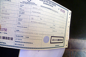
My Inca Trail pass |
I crossed my fingers and arrived at the small wooden counter to show the inspector both my passport and the photocopy of the old one. They gave me a ticket and let me through straight away with little more than a grunt. Obviously he was one of the easy going inspectors.
With my pass in hand, I was now in, I stepped onto the swingbridge and crossed over the roaring Urubamba River. The river barrelled over a whitewash of cascades over huge boulders. On either side of the river was a lot of bare rock indicating the power of the torrent during the floods of last January. Either side of the river were landslides of giant boulders that have rolled down the sides of the mountain during floods and earthquakes past. Once on the other side of the bridge, I waited for everyone else to pass through one by one as they had their passports inspected.
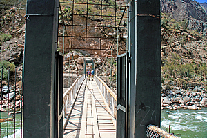
The swingbridge |
The ledge I was standing on was rather interesting. The track steeply rose above it indicating a slip had come down through here a few decades ago. There was a small wooden cross with a tiny white plastic vase in front filled with withering red flowers. Perhaps someone had recently died here.
Looking downstream there was a derelict wooden front door in front of some thick scrub. This was the first indication that people lived here. It must be the entrance to somebody’s property, or perhaps a storage place. It looked intriguing and if it were not for the steep track leading from the platform, this could have just about passed as being an interesting start to the trail.
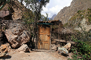
A random door on the other side of the river |
A large blue train passed on the other side of the river, clinging precariously to the side of the mountain above the hut and heading further downstream along the impossible railway line.
Within five minutes our entire party had regrouped, so Wilbur gave us our final briefing. He told us that the porters have right of way, and when they do come to pass or overtake us, we need to move into the hill side of the track so they can pass us on the outside of the track. If they are approaching from behind, we need to call out ‘porter’ to let those in front know of their approach. We had to be good to them as they were each carrying twenty five kilogrammes.
Wilbur led us up the steep section around a gate and onto the main path. Thankfully the steep section was very short. Ahead of us the trail was wide and smooth. The trail extending behind us towards Cuzco was little more than a goat trail worn away by centuries of farm activity.
<< Previous | Next >> |
|
||
About this Page
|
||
|
|
|
Where is Walkabout Jeff? |
|
|

|
|
What is happening in Walkabout Jeff's hometown?
|
|
|

|
|
Who is Walkabout Jeff?Any normal person's idea of going out involves going to the local pub for a drink with a few mates. Walkabout Jeff isn't normal.
|
|
|

|
Follow Walkabout Jeff |
|