--- Archive files ---
Home > Treks > Inca Trail > Day 3 > 3.3 |
Cemetery
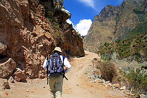
THE START of the Inca Trail was wide and gravely, of a grade that a quad bike could easily travel on. As we climbed the steep section over the first bluff, I looked back at the view over the swing bridge. The group of red porters were coming across now, so very soon they will be passing us. Our blue porters were not far behind now standing in queue behind the ticket gate. No doubt they will be presenting tickets showing the weight of their packs.
Wilbur leads the way |
We continued walking along the track passing the occasional local farmer coming the other way herding his donkeys or alpacas. The animals were loaded with produce to take to the station or perhaps to a local market. The land immediately surrounding the trail was pretty barren with patches of gnarly scrub. The sun was starting to beat down on us. It wasn’t hot, but it was very strong thanks to the air at this altitude being so thin. It was hard to believe we were two thousand six hundred metres above sea level. After all were at the bottom of such a precipitous valley with a significant river just metres below us.
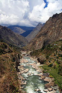
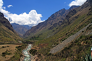
The Urubamba River thundered below us, rushing down the now distinctively V shaped valley towards the Amazon. The sudden change in shape of the valley indicated we were now below the terminus of the huge glaciers from recent ice ages past.
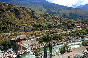
Looking back over the swingbridge |
The red group of porters caught up to our group within minutes of us leaving the swing bridge. I could hear someone behind calling out “porters” so we pulled over to the left hand side of the track towards the bank allowing them to pass. They walked at a surprisingly brisk pace considering they were heavily laden with their twenty five kilogramme packs. It was a bit disconcerting though with their packs being covered with red waterproof sheets and their legs covered with red waterproof rain trousers as if they were expecting heavy rain. There were more clouds in the sky now, so maybe they knew something that we didn’t. I certainly wasn’t expecting any rain after such a glorious start to the day.
Looking downstream |
Though that being said we were in a very mountainous area. I recall a couple of hikes I have done in the Southern Alps of New Zealand in the mid-1990s when the weather would be perfectly fine and twenty five degrees one moment, then it would suddenly cloud over as an Antarctic front would pass bringing bitterly cold rain, with snow falling just a couple of hundred metres above me. Such changes in weather are very dangerous causing many unprepared hikers to lose their lives. Although we were a lot closer to the equator here, we were very high in the midst of one of the greatest mountain ranges on Earth, so sudden changes in weather would be inevitable here.
Interestingly the porters were wearing shabby shoes, some only wearing sandals. They were certainly not wearing the footwear I would have expected professional porters to be wearing. Then again I should have expected they would be inadequately shod from my experience earlier this year of seeing the ragged porters climbing Mount Kinabalu.
The red porters passed us and regrouped into a line of two porters wide marching ahead like soldiers. Curiously there was a farmer wheeling a wheelbarrow immediately behind the porters, giving the impression that his job was to carry anyone who collapsed behind the group.
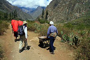
Farmer with a wheelbarrow following porters |
Shortly afterwards someone behind me called out “porters” again so we moved over to the bank again to let them pass. This time the blue porters passed us. They were our group carrying our gear. They walked very fast despite carrying their heavy packs containing our food and equipment for the trek. Within seconds they walked past us and formed a fast marching group like the group ahead of them, though they didn’t have a wheelbarrow man behind them. Perhaps our group of porters were tougher than the red porters. So long as they can get us all to Machu Picchu in three days’ time that’s all that matters.
This side of the valley suddenly opened into a small bowl. The wall of rock behind it towered a good one and a half kilometres high. Then I realised we were now high enough to be in a glacial area once more. A massive glacier would have come through here in an early ice age, but a more recent ice age would have carved a shorter glacier deeper into the valley up to the swing bridge now quite some distance behind us. In the tens of thousands of years since the last ice ages the river has continued to carve deeper into the granite valley.
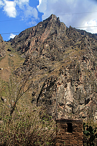
Wall of rock |
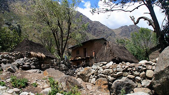
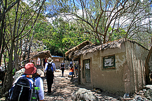
The giant wall of rock towering to our left revealed the giant folds of granite demonstrating the distinctive non-Newtonian fluid contortions typical of rock that had gone through massive geological uplift processes. Several small huts where the locals lived sat near the track nestled at the base of the massive wall of rock. The huts were made of stone or mud brick, or in some cases a combination of both. Wilbur told us the stones used to construct the houses were either from debris come down off the rock face above, or they had been picked up from the trail itself. This part of the trail had mostly worn away due to the excessive use by the villagers over the past five hundred years. The displaced rocks had been taken from the track and used to build their huts.
I didn’t see anyone around the huts though. Perhaps they were all out working or maybe some of them were hiding inside their huts. The huts themselves were a bit hard to see though as they were surrounded by rustic natural looking walls constructed of stone and rough-hewn timber. Perhaps these walls had been built to maintain privacy from the five hundred tourists per day completing their once-in-a-lifetime pilgrimage and their porters who were supporting their dreams. Wherever the people who lived here were working or hiding, they were living a very bucolic existence typical of people who lived in remote alpine areas.
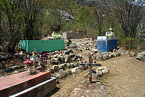
Cemetary |
A little further up the track we reached a cemetery above the side of the trail extending up the gentle slope to our right. We stopped there as Wilbur explained the origins of the graves, and the nationalities of those buried there. Surprisingly one of the graves belonged to an Australian. The graveyard contained a number of terraces made from rows of loosely placed stones. The graves were large blocks of concrete no doubt encasing the remains of the dead. Some were very plain and derelict. Some had small crucifixes and flowers on top. The concrete sarcophaguses were painted either white or the blue used in the front doors of houses. Some were unpainted grey concrete starting to crumble apart. Surrounding the tombs were large rough stones rolled down from the massive wall of rock above the village, and scrubby windswept trees barely surviving in the harsh terrain.
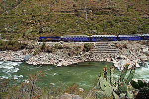
Train to Machu Picchu |
Once finished at the graveyard, we walked further along the track watching another train pass on the other side of the river. It was full of people taking the easy way through the precipitous gorge to the Incan emperor’s retreat at Machu Picchu. We were taking the hard way, but we were doing real deal taking the genuine pilgrimage gradually extracting ourselves from twenty first Century civilisation travelling five hundred years back in time.
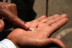
Natural Incan dye |
Wilbur stopped again to show us a cactus growing beside the track containing small berries. He picked one of them and crushed it between his fingers, explaining that it created a rotting blood red dye commonly used by the Inca five hundred years ago, but still used by the local people here. Indeed some of the bright purple dyes used in the alpaca wool in the village we had visited yesterday had been created from this berry.
Scrubby trees draped with Spanish moss provided some shade from the strong sun as we passed another small village along the trail. This village was just like the previous one - drab huts made of stone and mud brick for the reclusive locals. At the end of the village, the track passed through some steep terrain passing a rather broken wall of rocks. It was hard to tell whether they were natural or man-made. There were no rocks on the track but the rubble rocks continued down the bank on the other side through the scrubby trees down towards the river now quite a long way below us.
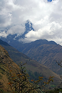
Mount Veronica |
The snowy peak of Mount Veronica suddenly appeared behind us. This mountain towered over two kilometres above the valley floor to around five thousand seven hundred metres above sea level. It was covered in thick cloud but we could now see the summit and its precipitous rocky front face in a break in the clouds. It was named after the woman who was the first person to reach its summit.
We walked a bit further before seeing a few more huts. The terrain was less steep now, but it was obvious this village sat on a large natural fan where rocks had tumbled down over thousands of years. The huts were perfectly nestled in amongst the rubble of the rocky fan as if they themselves were huge boulders fallen off the mountainside.
The narrow dirt track passed in between the stone huts where people lived. As in previous villages we had passed through, there was very little activity here. It was evident though that people lived here. They must all be away perhaps in Ollantaytambo delivering produce, or trading in the other nearby villages, or maybe even working in one of the corn farms we had passed in the glacial valley before the start of the trail.
Stone walls surrounded each house concealing much of it from view. Perhaps there were people inside these walls unseen observing the strange tourists walking past their houses day after day.
Once past these huts there was a big enough gap in the trees to see the gully from which all the rubble has come down from. We could now see a long way up the mountain, to where near the ridge summit a huge rock was sticking out at a very unnatural forty five degrees about eighteen hundred metres above us. The rock looked like it could fall at any time, and if it did, it would be incredibly dramatic. The rock stuck out a good fifty to sixty metres and seemed to be about thirty metres wide.
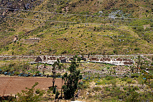
Salapunku |
A little further along the trail I saw the Incan ruin of Salapunku across the river just under the railway line. At first glance it would have passed as a partially demolished railway station, some thirty metres wide and perhaps five to ten metres across. However it was a genuine Incan ruin on a small grassy fan at the bottom of a very old landslide. The fan could very well have been used for agriculture.
The name Salapunku is derived by a combination of the Spanish-Quechuan word for salon – a hall or room, and the Quechua word punku, which means door. The name therefore meant doorway of a hall.
Another train passed us winding its way down the other side of the valley taking the easy way to Machu Picchu. Looking down the valley, the mountains were standing a bit further apart in a glacial U shaped valley as the river started to sweep around to the right. Cloud was building up over the tops of the mountains downstream.
Looking back upstream |
Once past the village, we continued walking amongst the row of pylons that ran down the length of the valley. They carried electricity from some power station unseen in the distance up towards Cuzco. Here the terrain suddenly steepened and we started ascending a moderate incline against the two hundred metre high river bank. We continued following the river until deciding to rest at an embankment exposing obvious layers of stratification. These layers had been deposited during each of the ice age glaciations. From here the view back to the start of the track was stunning, with the river cascading towards us far below, and the towering pinnacle of Mount Veronica providing a strong backdrop.
Village |
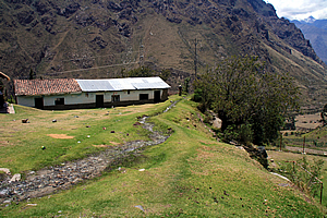
The track continued going higher to the top of the river terrace upon where we reached another village. The houses here were all close together and built from stone. They were of better construction than the houses we had passed earlier. Unlike the previous villages we had passed, there were a few people here. The houses here were very close to the trail narrowing its width down to about a metre and a half.
After five minutes of walking through the village, we found a dark rest area with benches built from rocks under the shade of a thick canopy of trees. Unlike down in the Amazon where the light was soft and filtered through the rainforest haze, the sunlight up here at high altitude was very harsh, creating huge contrasts between sunlight and shade. We stopped here for morning tea. The stone seating in this rest area wasn’t very comfortable and it was surprisingly dark under the thick canopy of trees just above our heads. Across the trail were a couple of stalls where a few people bought a drink.
Incan water channel |
A couple of us needed to use the toilet, so we left the rest area and followed the main track about twenty metres further before turning off on a goat track going across a grassy field where a stream ran along the middle of the ridge. The path of the stream was concealed with stones. It was strange seeing an otherwise natural looking stream running along the top of a ridge. That was a clear sign this was a man made channel. We reached the toilets and used them before returning to the rest of the group to set off to start the first substantial climb of the trek.
<< Previous | Next >> |
|
||
About this Page
|
||
|
|
|
Where is Walkabout Jeff? |
|
|

|
|
What is happening in Walkabout Jeff's hometown?
|
|
|

|
|
Who is Walkabout Jeff?Any normal person's idea of going out involves going to the local pub for a drink with a few mates. Walkabout Jeff isn't normal.
|
|
|

|
Follow Walkabout Jeff |
|