--- Archive files ---
Home > Treks > Inca Trail > Day 3 > 3.4 |
Ruins at the Bend
ONCE rested at the dark rest area, we left not realising what was ahead of us. We had only walked a few metres when the trail split into two. The main trail started heading downhill, but we took a side track heading up the hill.
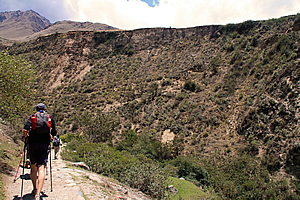
Long ascent above the river |
Initially we thought little of the climb until we came around a small spur and saw the track ascending into the back of a long gully, then up the other side. Even from here the climb appeared deceptively gentle, but it was quite a moderately steep climb. We all took it rather slowly as the thin air here at two thousand eight hundred metres above sea level started taking our breath away a lot faster than we were expecting.
After what seemed like ages, I reached the back of the gully where a small stream trickled through thick scrub. From there the trail steepened making for a challenging climb up to the next ridge.
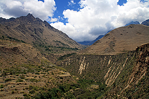
Looking back from the top |
Finally I reached the top at about three thousand metres above sea level. Here I was rewarded with a small flat area with a tiny hut and seating for resting and admiring the spectacular view across the mountains in either direction. We regrouped and rested here for ten minutes before continuing.
The track was reasonably flat from here as we went around a much smaller gully. The wall of an ancient ruin appeared over the grassy knoll ahead. There were a few steps up to the top of the next small plateau.
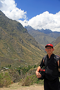
At the top |
From the top I could see the track starting to descend into a small gap heading straight past the ruin. We turned right off the track to stop at a small flat grassy area. From the edge of the grassy flat was an amazing view down the Urubamba River. Below us the smaller Cusichaca River (Quechan for Happy River apparently) came out from a deep valley to the left to meet the main river. Both rivers slowly wound their way far below us at the bottom of the precipitous mountains surrounding us. Although we were high above the valley floor, we really were only a fraction of the way up the steep face of the mountain.
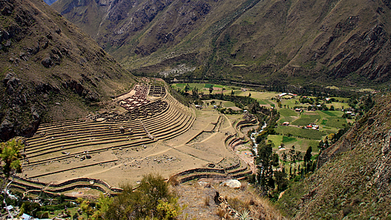
The two rivers met at a fairly large flat area across the other side of the small river and on our side of the main river. The flat contained several terraces following the contours perfectly to create level fields for the farmers of the village that had once stood here hundreds of years ago. This village was called Patallacta, the town on the hillside. Each layer of terracing got smaller as the flat gradually merged into the hill. Towards the top of the terraces was the remains of a village, essentially a townhouse estate of stone buildings with their roofs missing. The roofing must have been a form of thatch that has long rotted away out of existence.
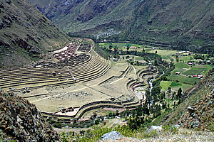
Patallacta |
The village appeared deceptively small below us, but it would have covered a wide area. There was a track below us passing the village. This would have been the main route from the last village we had passed, Now I understood why we had climbed this route.. People walking along it would have only a fraction of the view that we had from up here. This would have been a thriving farming village in its day five hundred years ago, but it has long since been abandoned as an archaeological site. The villages which were currently inhabited were either behind us, or further up the small valley.
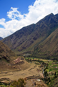
Patallacta |
The track below us indicated we were going to be following the small valley upstream now. The terrain on either side of the Urubamba river must be about to get a lot rougher further downstream towards Machu Picchu.
We stopped there for about fifteen minutes while Wilbur explained the history of this area, the village below us and the nearby fortification.
The fortification was Huillca Raccay, strategically located above the rivers. This was used as a watchtower controlling the entrance of the Cusichaca Valley. The graves of soldiers have been discovered in small caves in the steep ridge towering above the fortification. These soldiers had holes in their skulls. These have been shown as evidence that the Inca had relatively sophisticated medical procedures in treating head trauma. The holes in the skull were surgical incisions to relieve the build-up of pressure from a traumatic blow to the head by enemy invaders. This procedure was often life-saving. Though in the cases of the soldiers discovered in these caves, the surgery had not succeeded.
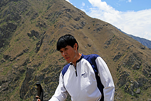
Wilbur talking about the ruins |
In its time the village would have contained one hundred and fifteen dwellings serving as a stop for the Inca heading towards the retreat at Machu Picchu. The village was also used to house the local farmers and the soldiers who stood guard here at Huillca Raccay. The village is believed also to have been used for religious and ceremonial functions. Archaeologists say this small area produced enough agriculture to support up to five thousand people.
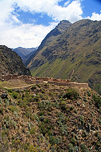
Huillca Raccay |
Pallacta was very instrumental in ensuring Machu Picchu was never discovered during the Spanish invasions. In order to hide it, Pallacta and several other settlements were burned by Manco Inca Yupanqui during his retreat from Cusco in 1536. The burning of the villages successfully discouraged the pursuit from the invading Spaniards at the time and Machu Picchu became no more than a mythical legend for hundreds of years before its rediscovery in 1911.
Following the Spanish invasion, the land in this valley was left to dry returning to its barren state. Although fifteen families now farm the narrow terraces of this valley, they are barely able to scratch a living from it. Almost nothing can grow here during the five month dry season.
The Inca on the other hand were very successful at farming the land. Unfortunately the key to the amazing success of the Incan farmers has been lost with time.
<< Previous | Next >> |
|
||
About this Page
|
||
|
|
|
Where is Walkabout Jeff? |
|
|

|
|
What is happening in Walkabout Jeff's hometown?
|
|
|

|
|
Who is Walkabout Jeff?Any normal person's idea of going out involves going to the local pub for a drink with a few mates. Walkabout Jeff isn't normal.
|
|
|

|
Follow Walkabout Jeff |
|