--- Archive files ---
Home > Treks > Inca Trail > Day 4 > 4.4 |
At the Summit
IT WAS a huge relief to be at the highest point of the Inca Trail. A small sign welcomed me to 4215 metres above sea level, higher than I had ever been. The sign was nothing more than a large wooden post with a flattened triangular pyramid top. It had four squares with diagrams and words down its length. They read as follows:
Warmiwanuska Abra (Image of two mountains with a track in between)
4215 m.s.n.m. Warmiwanuska
Paramo muy humedo subalpino subtropical (Image of three tufts of grass)
Mirador (Image of two people at a view point looking through binoculars)
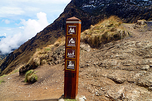
The summit of the pass |
I very quickly regained my energy and felt invigorated in the fresh mountain air as I put my pack down on one of the stone ledges where our porters were sitting. The ground here was mostly gravel only because so many people have rested up here. Surrounding the gravel was a tussock like grass that grew well. The snow line was still a hundred metres above me.
I looked down the other side of the pass, seeing where the track zig-zagged way down the valley to where we will be having lunch at a location unseen in Pacaymayu six hundred metres down the 2.1 kilometre long track, but I also saw the track going up the other side to the second pass, one that wasn’t as high as this at some 3900 metres above sea level. That pass appeared reasonably flat, but it was a long way away. The pass was only about a hundred metres below the surrounding peaks.
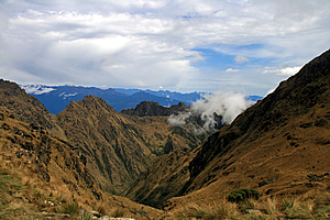
Looking down the other side towards the next pass |
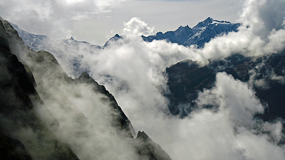
Beyond the yellow brown range, were another two ranges blue grey and very distant looking towards the great Amazon Basin unseen over the horizon through the clouds. Cloud was starting to pour into the valley below me, so the view in this direction wasn’t going to last much longer.
Looking behind me, the clouds were ascending the Llulluchapampa Valley and there wasn’t much of a view left – just the arête valley containing the abandoned Llulluchapampa campsite. The ridges on either side were concealing our view. The gullies were all filled with brilliant white cloud, but the blackened spurs were still clear.
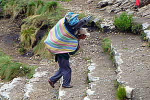
Porter reaching the pass |
I could see the last campsite where we had stopped on our way up this morning, and in brief moments when the cloud cleared enough, there was a view of the village at the bottom of the gully now some thirteen hundred metres below me.
To the left were all the red porters sitting on steps carved into the soil, and our blue porters were sitting on benches cut out into the dirt to my right, so I went and joined them. Several minutes later Julia arrived, and over the next half hour everyone else arrived one by one in the following order. Marissa arrived about ten minutes after Julia, then Hannah, Ryan and Kristen, Michael and finally Kathleen.
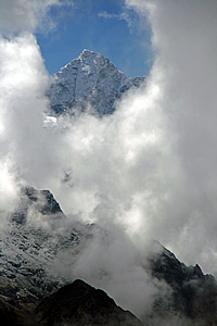
Mountaintop showing through the clouds |
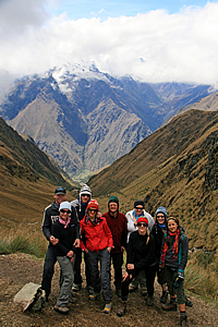
Achievement! Most of our group at the summit |
I climbed up to a small lookout at 4223 metres – eight metres above the summit. That was the highest place I will be travelling to on the trail. A few small stone cairns were atop the small platform where I stood. From there I could see our blue porters with the rest of the group directly below me, and the red porters with a few other porters sitting on the seats carved into the side of the hill on the other side of the pass. Additionally some of the porters who had been based at the camp at the bottom of the valley were now already starting to pass, no doubt having gone way ahead of their groups.
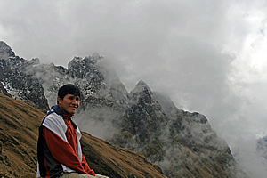
Wilbur in his element |
I returned to the rest of the group in just as Amanda arrived. Wilbur had arrived too so those of us who were up here posed for a group shot. At that stage Amy, Derek and Avani hadn’t arrived, but we had to keep moving to head down the hill for lunch. Carlos was looking after them anyway. Our porters had just left and by now the cloud was quickly ascending the valleys on either side of the pass, blocking much of the view.
<< Previous | Next >> |
|
||
About this Page
|
||
|
|
|
Where is Walkabout Jeff? |
|
|

|
|
What is happening in Walkabout Jeff's hometown?
|
|
|

|
|
Who is Walkabout Jeff?Any normal person's idea of going out involves going to the local pub for a drink with a few mates. Walkabout Jeff isn't normal.
|
|
|

|
Follow Walkabout Jeff |
|