--- Archive files ---
Home > Treks > Inca Trail > Day 4 > 4.5 |
Steep Descent to Lunch
NOW I can’t stand walking downhill at the best of times. By now it had dawned on me that the descent from the pass will be a lot steeper than the ascent. Fortunately the track here was all steps of large stones perfectly joined together by the Inca five hundred years ago. The track has been so well built that it has only required minimal maintenance since its initial construction. This was most unusual, but a testament to those who had built it so long ago.
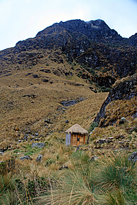
Toilet just below the pass |
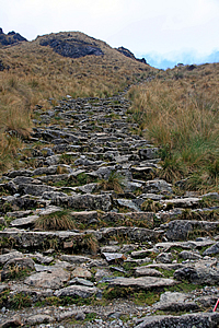
Stairs descending the pass |
Wilbur led the way. I closely followed him. By coming second I was hoping to be the one setting the pace on the long downhill. I used my walking pole with the rubber end to navigate my way down.
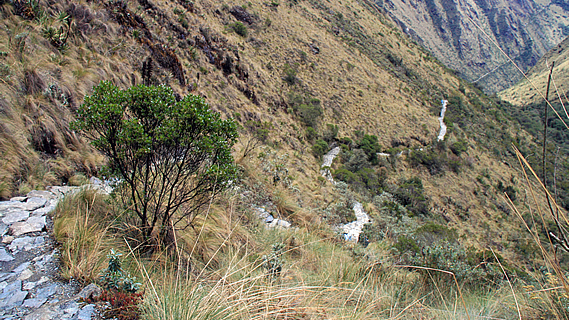
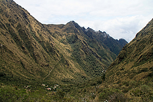
Long steep trail down the valley |
About five minutes below the pass we reached a stop where a small timber thatched toilet was about thirty metres off the track through the thick tussock like grass. A small stream passed the toilet hut from a gully coming off the rocky mountain top still not far above us at about four thousand six hundred metres above sea level. We stopped here for about five minutes whilst a couple of members of our group did their business.
We continued descending, passing through a small cave and weaving out the bottom. Wilbur explained to us that several people have died on this part of the trail. They were mainly porters who were taking the downhill a bit too fast and had tripped over to roll down the precipitously steep hill to their deaths. Perhaps after going uphill for so long they had forgotten about the extra precautions needed when going downhill.
Campsite and trail continuing up the hill |
The long stairway we followed led towards Pacaymayu, a small campsite far below us. There were small tufts of tussock grass growing in the cracks between the stones. No doubt these plants will be removed during the annual maintenance in February each year when the track is closed to tourists.
The track was very well maintained, thanks partly due to the track being closed during February each year when workers would conduct any clearing and other maintenance work. Another reason it was so well maintained was due to the Peruvian government setting a limit of five hundred people (including porters) each day. There was talk of reducing this number further as a measure to further reduce deterioration.
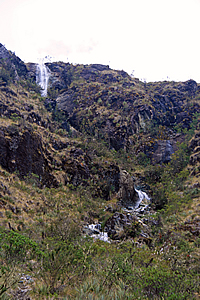
Waterfall |
Fortunately as the track was in such good condition we lost altitude very quickly. I could already feel the air thickening, but that was mainly due to the humidity rising as a small cloud enveloped us.
The cloud passed us and we continued heading down. The pass behind us was now shrouded in cloud, so I imagined Amy, Derek and Avani would be in the cloud when they reached the summit. They will be denied the spectacular view I had been rewarded with at the top.
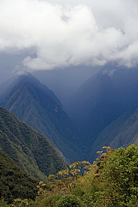
We reached a point where the glacial gully below us suddenly steepened, causing the track to now follow the side of the mountain towards some scrubby forest further down the valley now curving to the right. The track started to level, and now I could just make out the track that we will need to climb up after lunch, heading towards the second pass. Looking back up I could see where the track had gone through the caves and passed a large slip I had not previously seen. The slip was a scourge in the otherwise pristine mountain showing potentially how steep and treacherous it can be around the tops.
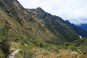
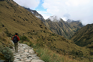
Trail |
The descending trail suddenly steepened again into a staircase winding its way quite randomly down the gully. In the distance the track we will be going up in the afternoon, I could see a round ruin right by the track – the ruins of Runkuraqay. This was something to look forward to this afternoon as we will be passing it.
I saw a waterfall coming out of what had been a small glacial valley above us. It was part of a long cascade plunging from one hanging valley into the second hanging valley which we were travelling down. These were the headwaters of the Pacaymayu River. I could now see the Pacayamayu Campsite below at the bottom end of the hanging valley we were descending. We continued downhill until crossing the stream just above the campsite. It was fantastic to hear the sound of running water again after the desolate silence of the mountaintops. Further down the valley I could see the scrub was turning into a forest, this was the first sign of the perpetual forest of the Amazon into which these rivers drained into. We entered some very jumbled scrub that had bromeliads with dull red flowers growing on the thin branches.
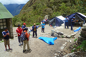
Campsite at the bottom of the valley |
A group of tents suddenly appeared in a small clearing next to the trail. We continued walking another three minutes until we entered the campsite of Pacaymayu and were greeted with the standing ovation of the porters who had already set up the two large tents and had nearly finished cooking lunch. They must have run down from the pass.
Having arrived at our lunch stop, we washed our hands in the row of little blue bowls filled with warm water with a small cheap bar of soap as we had done in all previous meals to date. It was going to be a while before Sam, Avani and Amy were going to arrive, so we rested whilst awaiting their arrival. Time wasn’t an issue as Wilbur assured us we were a fast group and were running ahead of schedule.
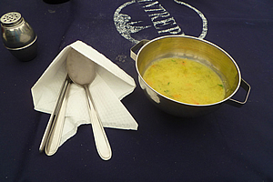
Soup |
From our vantage point on the grassy flat I could see back up the valley where the stream was plunging down cascading waterfalls. The pass had disappeared out of view by a steep spur. Looking downstream, the valley continued steeply downhill for a few more hundred metres before plunging into another old glacial valley. No doubt it was plunging down waterfalls again into the depths towards the Urubamba River only a few kilometres away yet around a thousand metres below us.
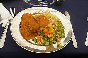
Main course |
Although the Urubamba River was completely concealed from view, I could see the mountains on the other side of it. The mountains rose dark and at this point I could just see Mount Veronica before it disappeared behind the black cloud that now covered the valley below it. No doubt it was raining down there.
Whilst awaiting the others to arrive for lunch, I crossed the stream to the small toilet block. On the way back I could hear some rowdy louts swimming in a small pool in the stream. Going by their accents they were definitely Australian. I briefly saw them on the way back to our camp.
Appcoaching storm |
It was forty minutes after our arrival when Amy, Derek and Avani finally arrived. We joined the porters in giving them a standing ovation. The porters then announced lunch was ready, so we entered the tent and sat around the table for another gourmet meal. Once more Ricardo the chef delivered very well. He started with serving a vegetable soup. The main was a battered chicken with a vegetable mix of potato, beans and carrot, and noodles.
We left the tents to continue our hike only a few minutes after finishing eating. This was a bit too soon as our stomachs hadn’t settled yet. Perhaps Wilbur had been a little too optimistic in our progress earlier and figured if we left any later some of us would not arrive until after dark.
Upon leaving the tent I could see the cloud I had earlier seen down the valley was now advancing quickly towards us. The mountains on the other side of the Urubamba River were now completely hidden amongst the mass of black storm cloud. This was potentially going to make the traverse of the second pass more difficult than the first.
<< Previous | Next >> |
|
||
About this Page
|
||
|
|
|
Where is Walkabout Jeff? |
|
|

|
|
What is happening in Walkabout Jeff's hometown?
|
|
|

|
|
Who is Walkabout Jeff?Any normal person's idea of going out involves going to the local pub for a drink with a few mates. Walkabout Jeff isn't normal.
|
|
|

|
Follow Walkabout Jeff |
|