--- Archive files ---
Home > Treks > Inca Trail > Day 4 > 4.6 |
The Storm
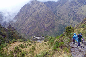
WE LEFT Pacaymayu climbing the steep stone stairway track around ridge and gully up towards the next pass. It was clouded over up there, and thick cloud was barrelling up the valley below us. Despite that I had only been walking for about ten minutes before reaching high enough to get another view of Dead Woman Pass towering surprisingly high above the campsite now tiny and perched in the gully below us. The waterfall bringing the stream that flowed through the camp plunged in two steps.
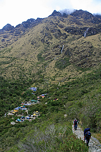
Ascending from the campsite |
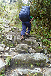
Porter on the steep trail |
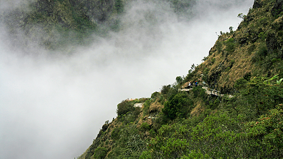
The landscape appeared a lot more dramatic from this side of the valley. The view must have been a bit intimidating for the Inca returning from Machu Picchu, seeing they had an enormous steep climb ahead of them. Through the thin haze I could see a dark line which I immediately recognised as the trail we had walked down from the pass. It looked rather ominous from here, but that was past history. This was a one way trail and I will never need to walk that section again. Now I had to concentrate on the climb ahead.
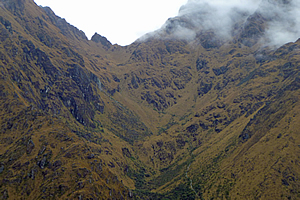
Cloud fills the valley |
The path I was walking along was very narrow in places, making it difficult for our porters to pass us. I was amazed as how quickly they had packed up after lunch and now nimbly they were attacking the steep path even though some were only wearing sandals. In stark contrast here was me in my flash boots carrying only a day pack and camera bag huffing and puffing along at such a slow speed despite being at peak fitness.
I could see liverwort type ferns growing along the side of the trail for the first time, indicating the rainforest area was near. Despite that I knew we wouldn’t encounter forest until dropping over the other side of the pass, having remembered seeing this pass from the top at Dead Woman Pass and the terrain had been moderate grassland.
Runkuraqay |
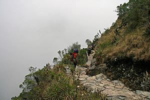
The rapidly advancing cloud quickly filled the gully behind us, taking away our view of the campsite. Rounding spur and gully, the view below was that of back further along the track seeing my fellow travellers inching their way up the steep stairway. The mountains blackened under the approaching squall.
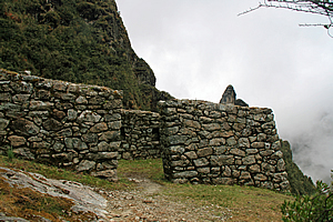
After nearly an hour of winding up the hill, we saw the round stone barrack of the lower part of Runkuraqay ahead of us further up. We walked up to it and grouped there. The thick cloud was very close to us still obscuring Pacaymayu below. A peel of thunder echoed in the steep slopes that surrounded us.
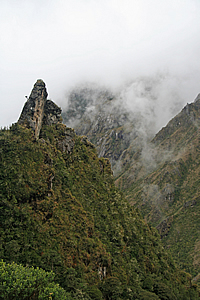
Precipitous terrain |
We assembled in the middle of the round temple and Wilbur began to explain the small ruin of Runkuraqay. The walls in the most part were a little over two metres high and inclined inwards to provide earthquake resistance. The walls around the front curve were about one point two metres high, a good height for admiring the view below. There were windows in the building pointing to the directions of all the paths of the empire. It would have had a large conical thatched roof held up by wooden poles. These had long decomposed leaving only the rocky walls.
The camp was visible again, up to the waterfalls, but the higher slopes had disappeared behind the cloud cover rising the valley like the fluids in lava lamps. There was a small square building about fifty metres below us. Some of the walls had small plants growing out of the joins. To our left the mountainside was precipitously steep with needle sharp columns of rock protruding vertically from the steep spur.
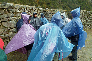
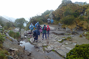
The storm hits |
Then hail started falling and we quickly put on our rain capes and ponchos. It was suddenly very cold with swirling wind. There was no point in us staying here as there was nowhere to shelter, so we continued walking up the hill getting pelted by the small hailstones and buffeted by the strong cold mountain wind. I had put the waterproof cover over my camera bag.
The steep and narrow stone track above the Runkuraqay fortress was difficult going as the strong gusty wind buffeted us with hail flapping our rain capes around, although it wasn’t as difficult as this morning’s climb. The stone pavers we were walking on began to get a little slippery but we continued onward and upward as this was our only way to stay warm in this severe alpine squall.
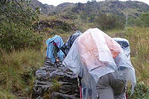
Hail falls as we continue towards the pass |
I had remembered the hail storm the other day at the tiny Incan village between Cuzco and Ollyantaytambo. Thankfully this storm wasn’t as ferocious as that tempest, but I did remember how long that storm had lasted. The hailstones created an awful noise as they hit and scratched against the thin cape of my raincoat.
Fortunately it didn’t last long. The hail quickly changed to steady rain and the thick clouds began to abate, rewarding us with a view of the round Runkuraqay fortress now quite a long way below us. It appeared very small from up here, just two concentric circles of stone wall with a few radial rows of stone between them to create rooms. From up here it looked like a bunker to house a large cannon. The wildly swirling cloud cleared just enough to reward us with a translucent view glimpse back to the top of Dead Woman Pass. The weather would be pretty savage up there now, though perhaps no more so than it had been here.
Above Runkuraqay |
It was about here that the track’s steepness lessened. We were above the very steep terrain and above the scrubby bush now entering another glacial accumulation gully. The track rose over the lip of the valley reaching a small pass marked with several small stone cairns on the side of the track.
The trail descended for a couple of metres before rising again on the right hand side of the gully revealing a small tarn coloured deep ochre from the tannin that had leached from the surrounding grass. This was called Laguna Cochapata. The surface of the tanning stained tarn bubbled with the falling rain as we continued to ascend following the ridge.
Dead Woman Pass across the valley |
I looked back across the valley we had scaled today. The cloud had lifted significantly and thankfully the rain was easing. I now had a clear view across to Dead Woman Pass. Only the mountaintops were covered in cloud now. I could just see the track along the other side working its way steeply up the precipitous gully towards the pass.
Upon reaching the top of the glacial gully, we found ourselves walking across fairly flat terrain towards the nearby second pass. We walked around another tarn unnaturally sitting at the edge of the plunging slope. On the other side looking towards the Urubamba River I could just see the snow of some higher mountains that we had not previously seen. The summits were concealed in amongst the cloud, but I imagined these mountains to be at least six thousand metres high.
Ruin at the top of the pass |
Finally we reached the top of Runkuraqay, at 3950 metres above sea level. It was a large round flat area about eight metres across surrounded by huge natural boulders. It was obviously man made into some kind of outdoor temple, perhaps an Incan Stonehenge. In the thick mist that occasionally engulfed us it looked like something out of Lord of the Rings, perhaps Weathertop. For the first time here I felt I was in a special spiritual place, although this was nothing compared to what we would discover over the next two days.
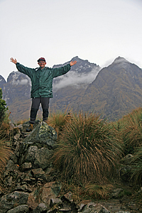
At the top of the pass |
The cobbled pathway passed through the middle of the round pass, but in the middle was a two metre wide circle of stones perhaps indicating a map of the local area. There were a few piles of rock surrounding the circular clearing, but it was hard to tell whether these were natural or man-made. Perhaps the jagged edges of the rocks surrounding the clearing had been carved into the shapes of the mountains.
Over the piles of rock to our left was a group of rounded mountain peaks enshrouded in mist. I had looked down on these peaks from Dead Woman Pass not thinking much of them at the time, but now they stood over us like giant sentinels.
The rain suddenly cleared and the clouds thinned a little so we decided to stop here for a rest for about five minutes. The clouds cleared from the other side giving us a view down the gully in which we were about to descend.
<< Previous | Next >> |
|
||
About this Page
|
||
|
|
|
Where is Walkabout Jeff? |
|
|

|
|
What is happening in Walkabout Jeff's hometown?
|
|
|

|
|
Who is Walkabout Jeff?Any normal person's idea of going out involves going to the local pub for a drink with a few mates. Walkabout Jeff isn't normal.
|
|
|

|
Follow Walkabout Jeff |
|