--- Archive files ---
Home > Treks > Inca Trail > Day 4 > 4.7 |
Ruins in the Clouds
THE STONE stairway steeply dropped from the second pass at Runkuraqay into the gully below us. Thick mist suddenly enveloped us and squally rain started falling again. Fortunately though it quickly cleared away leaving only the thick layer of cloud cover a good one thousand metres above us.
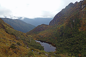
Swamp at the bottom of the hanging valley |
Below us I could see at the end of the gully a swampy tarn with black water stained with tannin leached from the surrounding vegetation. The bottom of the thick scrubby valley would be very swampy. Beyond the end of the lake the land dropped off very steeply into the Aobamba River hidden a good vertical kilometre further below. The other side of the valley rose into more mountains to the distance, not looking as steep as the mountains here. The Aobamba River drains into the Urubamba River at some distance below Machu Picchu. The combined river forms just one of the many tributaries of the Amazon.
I was walking with Wilbur at the front of the group. I asked him how long it would take him to do the trail if we were to do it alone. He didn’t know as he had never tried it before, but he said that Carlos had once completed the entire trail in twelve hours. He said the porters have an annual race running along the trail. It is not a well-known race though, and certainly not like the Kinabalu classic where anyone can enter. It must be amazing for the porters to be able to run the trail uninhibited by the heavy packs they had to carry, but carrying the packs on a regular basis along the trail would be a fantastic way to train for the race.
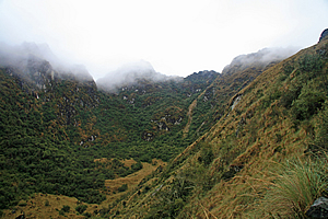
Looking back towards the pass |
We continued down the steep paved trail towards the swamp. The surrounding tussock grass gave way to very thin scrub once we were within a hundred metres from the bottom. Looking back up the mountain, it was obvious we had come down across the back of another small glacial valley with the back of it very steeply rising into the thick clouds above. The pass was once more engulfed with cloud. Anyone crossing the second pass from now on would not have any view at all. The cloud was definitely descending with the onset of night.
As we passed the lip of the swamp, thick scrub robbed us of most of our view apart from the occasional clearing from where we could see the perfectly mirror smooth tarn below us. Looking ahead, thick white cloud was quickly coming up the valley towards us. Soon we will be in thick fog.

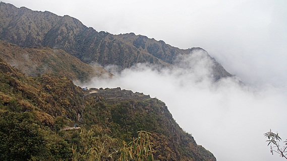
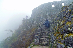
Stairway to Sayamarca |
We continued walking in amongst the thick scrub until reaching the end of a spur from where we were rewarded with an amazing view. Ahead of us was the walled village ruin of Sayamarca perched on the edge of the precipitous slope below us. Thick cloud covered the valley beneath the ruin and rising above the gully behind it. This really highlighted the dark mysterious ruin, giving the illusion that it was at an enormously high altitude. We followed the track towards it but very quickly it disappeared into the cloud, highlighting its alpine mysteriousness.
The swirling white fog cocooned us with a heavy cold dampness. I recognised what this meant having experienced similar conditions when hiking in New Zealand. The cold heavy dampness is an indication of the onset of prolonged rain. The spectacular view of Machu Picchu in about forty hours time was slipping away.
The track seemed to get narrower and more precarious as rain began to fall again. As expected it was a lot colder this time. We entered a dark forest of gnarly trees making conditions even more miserable. Then we suddenly arrived at an intersection. The main track doubled back in a hairpin bend continuing its gradual descent. A narrow stone stairway carved into the rock face with trees overhanging high above led up to what I presumed was the ruins of Sayamarca that I had seen just before it was enveloped in cloud.
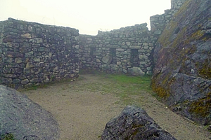
Sayamarca |
Wilbur offered to take us up the narrow stairs, but anyone wanting to go to the camp was welcome to do so. The camp was only about ten minutes walk away. I thought of the next campsite where no doubt our tents were already pitched with a dry bed and hot chocolate awaiting us. Too bad, that can wait. I was here only once in my lifetime, so come hell or high water, I was going to see these mysterious ruins in the clouds.
I followed the rest of the group behind Wilbur as we walked up the slippery steps in the rain taking care not to trip on our rain capes.
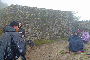
The rain suddenly stopped falling just as we reached a large circular courtyard which appeared to be the top of the village. Thick mist enshrouded the village with a ghostly translucence. We were in a round temple area at the top of Sayacmarca, with a few levels dropping off diffusing into the thick fog. Visibility was only about twenty metres. The walls with gaps full of moss leant inwards perhaps to deflect the wind which fortunately wasn’t blowing today. It was deathly silent up here, but that was broken by Wilbur starting to explain the history of the village, and he pointed out a round brass plaque erected in 2005 marking this as a historic site. We listened intently as cold rain began to fall again.
Sayamarca |
He said that Sayacmarca means “Town in a Steep Place”, which was very true. The town is located on the tip of a very prominent ridge about a vertical kilometre above the Aobamba River. There was a track from here leading down into the valley below. The purpose of the village is unknown. It is not fortified, nor does it contain enough terracing to be self sufficient, let alone to produce agriculture. Even if it was big enough, the climate of this exposed location would not sustain crops. It was probably not used for religious purposes either, as the standard of construction here (as good as it was though) was not of the quality of any of the temples the Inca had constructed. Unlike most of the other temples in this part of Peru, this one was initially built in pre-Incan times by the Colla. The Inca improved the construction following their invasion of the Colla. Now that was interesting. I imagined this trail had initially been constructed by the Colla, and all the Inca needed to do was to put the stone pavers on the trail route.
Sayamarca |
Once Wilbur had finished his presentation, he told us that we could explore the village, before heading down to the camp at our leisure. By now I was starting to feel rather chilled and rain was falling again. Five minutes of stopping had made quite a difference. I explored the city in the very thick fog now reducing visibility to ten metres. After a few minutes I decided it was time to move on towards the warmth of the campsite. I carefully headed down the precarious stone staircase back onto the main trail. The others had decided to either go to the camp straight away, or were lingering a bit longer in the ruins in the clouds.
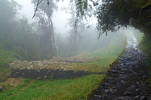
I walked along the track alone – the first time I had done so since the final stretch to Dead Woman Pass when the rest of the group had fallen behind. Even then I hadn’t been alone as I was walking with other people from other groups there. Now I was completely alone feeling the eerie serenity of the moss covered trees. The stone construction of this part of the track was amazing. It was held up by a one or two metre high retaining wall to the left, and the stones banked up against the side of the hill on the right. This trail had taken an enormous amount of work, and there was no way it was going to slip down the hill any time soon.
The rain had stopped falling and the fog was starting to thin. The light of the hidden sun was starting to increase so it was no longer dark.
Conchamarca |
I crossed a bridge perfectly formed on the trail, but with wooden handrails recently constructed no doubt for safety. Once across the stream, the trail followed it downstream passing several stone artificial terrace barriers that could have been used for growing produce or for creating irrigation channels, or to perhaps have stopped the stream eroding the ground near the trail. Above the terrace was the small tambo Conchamarca.
The track was going through cloud forest now. It was still rather stunted, but this was the first of the forest that would continue to expand and eventually merge in with the Amazon Rainforest far away down the valley. There was too much cloud here to see any view, and as I walked the trail alone, I wondered how much further it would be to the campsite.
<< Previous | Next >> |
|
||
About this Page
|
||
|
|
|
Where is Walkabout Jeff? |
|
|

|
|
What is happening in Walkabout Jeff's hometown?
|
|
|

|
|
Who is Walkabout Jeff?Any normal person's idea of going out involves going to the local pub for a drink with a few mates. Walkabout Jeff isn't normal.
|
|
|

|
Follow Walkabout Jeff |
|