--- Archive files ---
Home > Treks > Inca Trail > Day 5 > 5.4 |
Ruins and Forests in the Sky
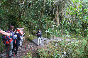
WE FOLLOWED the track downhill from the pass at Phuyupatamarka, dropping at a gentle slope into the thick moss covered cloud forest scrub. The forest took away much of the view of the very steep valley opening out below us.
Phuyupatamarka |
Phuyupatamarka |
After ten minutes we briefly encountered a steep area where the track went down a stone stairway and a small opening appeared in the scrub directly ahead. Through the opening I could see the top of a group of terraces at another ruin just across the gully about two hundred metres ahead. The ruins straddled a steep spur with terraces on this side and what now appeared to be the ruins of a stone village on the other side.
We continued following the track around the dark gully in between the view and the village. The stonework here was amazing holding the track onto the side of the very steep slippery slope.
Phuyupatamarka |
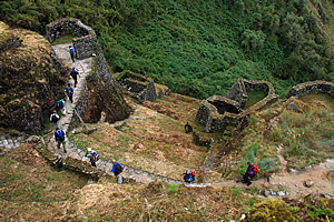
Upon crossing a small stream, the trail started heading uphill towards a stairway going up the stone walls of the terraces over the top of the village. A wooden sign said we were now in Phuyupatamarka, the same name as the pass we had just come down from.
Phuyupatamarka was named as the Cloud Level Town. It would have accommodated a few hundred people in fifteen buildings, two plazas, bridges, stairways and observation buildings built perfectly into the rugged cliff-side contours of spurs and gullies. The lingering cloud formations below often gives the impression the town floats on the clouds, hence its name.
As we started climbing the short stairway, we passed a stone irrigation system with liturgical fountains – known as “baths” - to hold water for drinking and irrigation. There was still water trickling through the irrigation system as if it were built very recently even though it had been abandoned for nearly five hundred years.
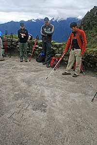
Wilbur describes the construction techniques used here |
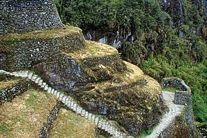
We reached the top of the village, from where we had a good view over the terraces down over the village on the far side which straddled across two small spurs and the miniature gully in between. The village was quite small, but it followed the steep contours of the mountain with numerous rounded structures jutting out. It was built in a rather complex split level arrangement with stone stairways linking between each level. There didn’t seem to be a main road through as the track we had entered came in over the top of the village and the track leaving left at the bottom. Travellers had to work out their own way down through the Dr Seuss style maze of stairways and house sites. The forest around Inipata had largely been cleared, but the ground was rather scrubby still and the stone walls had mosses, ferns, and grasses growing out of them.
Looking out from the village, there were many ranges of mountains, including some rather sharp pointed ones below us. There were numerous small clouds hugging the gullies of the surrounding mountains, but they were quickly clearing. It had obviously been raining through this area up till perhaps a couple of hours ago.
We descended into the village and walked to a temple courtyard where Wilbur drew diagrams in the dirt in a large flat area as we watched. He explained how the stone walls were constructed around the contours of the mountain and how the blocks joined together so well. Suddenly a hairy tarantula jumped onto Derek - that made us all jump. He quickly brushed it off his arm onto the dirt below. Wilbur quickly finished his presentation before we continued down the village to where the track continued at the bottom.
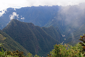
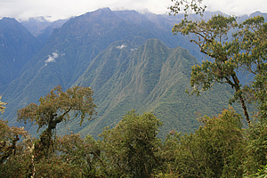
Machu Picchu Mountain |
From here Carlos pointed out a lopsided triangular mountain way below us which was now visible thanks to a small bank of cloud in front of us suddenly clearing. This was Cerro Machu Picchu – Machu Picchu Mountain. The ruins of Machu Picchu were on the other side of the mountain. At this village we were 3600 metres above sea level. The river was at 2000 metres above sea level and Machu Picchu was at two thousand four hundred metres above sea level. We had a twelve hundred metre drop to Machu Picchu. I was a bit over all the downhill we had done yesterday, with about six hundred metres drop from Dead Woman Pass, and another six hundred metres down from the second pass. The descent from here to Machu Picchu was just as long.
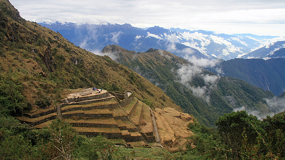
Looking around the mountain in the direction that we will be heading I could see the cloud forest will be thickening. There was one large clear patch in the forest over the front of a rounded spur which I noticed was covered in terraces. There didn’t seem to be the remains of any village there, but seeing the patchwork of terraces following the contours of the spur was quite amazing.
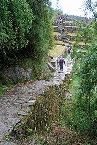
Trail at the bottom of the village |
Carlos told me this clearing was the agricultural terraces of Intipata.
We continued exploring the village heading downhill until reaching the trail at the bottom. From there we continued walking through the thickening forest, passing a stone bivouac under an overhanging rock that was just big enough to hold one person.
More cloud briefly enveloped us before we reached a break in the scrubby forest to see the Urubamba River rounding the bottom of Machu Picchu Mountain. The track was in pristine condition going through the very thick undergrowth in the very difficult terrain making our walk quite easy. The downhill wasn’t too bad here with the track now sloping gentle.
2nd Inca Tunnel |
We reached another break in the trees and across the other side of the river now unseen I could see a fascinating ridge. Forest went up the sides to almost the top to a very sharp erratic ridge that was picture perfect.
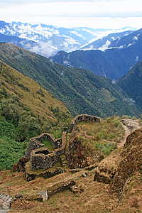
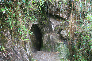
We reached another small ruin, a single rectangular stone building. Perhaps this was a resting place or a storage shed. It was at the top of a rather steep section of trail that twisted and turned its way down a steep stairway into a dark gully. Towards the bottom of the gully the track suddenly entered another cave, similar to the one we had walked through earlier this morning. We entered the dark elongated egg shaped entrance following the stairs down the slightly lopsided gallery to the other side some fifteen metres away.
Descending Trail |
Once through the cave, the track continued going steeply down the stairs (though not as steep as the section before the cave). The terrain here was very steep though, so the track had wooden handrails made from thin logs to stop us falling down the almost sheer drop below us.
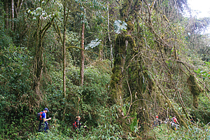
The trail levelled into a more gradual descent as we passed through the increasingly thickening cloud forest. The branches of almost all the gnarly moss covered trees were covered with bromeliads and tillansias. The moss growing on the trunks was very thick, very much reminding me of the trees in Fiordland in New Zealand. The thick forest was mostly quite dark, but when we did get a break in the trees, the view of the valley beyond was absolutely amazing. The clouds were beginning to lift now revealing the jagged peaks of the middle level granite mountains standing at around four thousand metres high above sea level.
Cloud Forest |
A small brown hairy caterpillar walked along the side of the path minding its own business as we passed. I had not seen many insects on the trail so far, but with going through cloud forest now I imagined we would be seeing a lot more.
From the next clearing we could see up the Urubamba River, seeing the precipitous forest covered valley in either direction fading away into the misty rain in the distance. The rain was quickly approaching. The trees in the cloud forest we were walking through was getting taller now creating quite an impenetrable forest. It was amazing that the Inca had managed to find a way down here, and that they had managed to find the remote Machu Picchu here at all. No wonder it had completely eluded the invasions of the Spanish inquisition.
Trail through the jungle |
We passed another small wall ruin by the side of the track, but this one was close to the encroaching forest. The ruins down here would be a lot harder to maintain here where the vegetation was so much more aggressive than along the first day of the trail in more arid conditions.
We were suddenly met with another small wooden signboard - We were at Intipata. We walked around the end of the spur we were straddling, and through a gap in the trees I saw the terraced field I had seen earlier.
<< Previous | Next >> |
|
||
About this Page
|
||
|
|
|
Where is Walkabout Jeff? |
|
|

|
|
What is happening in Walkabout Jeff's hometown?
|
|
|

|
|
Who is Walkabout Jeff?Any normal person's idea of going out involves going to the local pub for a drink with a few mates. Walkabout Jeff isn't normal.
|
|
|

|
Follow Walkabout Jeff |
|