--- Archive files ---
Home > Treks > Inca Trail > Day 5 > 5.5 |
Campsite perched at the Edge of a Cliff
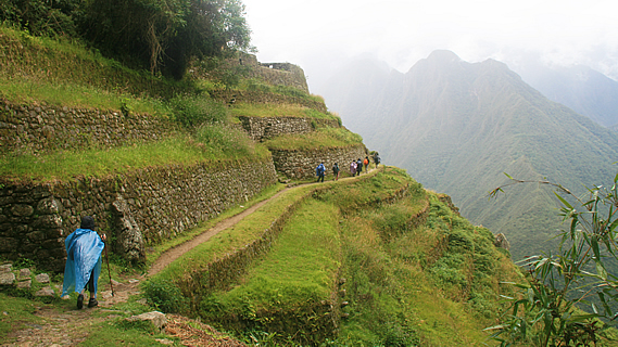
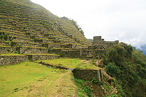
RAIN started to fall just as we left the thick cloud forest and entered the steep grassy terraces of Intipata. We briefly stopped to put on our rain capes before walking across one of the grassy terraces devoid of trees, looking like brightly coloured ghosts in the mists with our capes gently flapping in the slight cold breeze. The terraces followed the contours around ridge and gully.
Wilbur's rain dance |
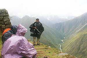
Finally we stopped along the top where once more Wilbur explained the area, and once more it was raining. By now we had decided his presentations were a form of rain dance. This was especially apparent when he mentioned the name Intipata means “Sunny Place”. He explained the sunny microclimate here made this area well suited to the potatoes, sweet potato, maize and fruit had been grown here during Incan times.
Descending the stairs of Intipata |
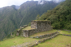
There were no buildings here apart from a couple at the bottom which could have been used as storage barns and perhaps a small house for the farmer who tended the crops. The lack of buildings here meant Intipata served little residential or religious purpose, but it could have been used as a strategic location where communication could occur between Machu Picchu and settlements along the Urubamba River. A communications station had been set up on top of Cerro Machu Picchu and another one here. There would have been another one at Phuyupatamarka and others further along the trail back towards the upper Urubamba River.
View to tonight's campsite |
We walked across the terrace until reaching a stairway in the middle. We followed the steep stairway down to the ruins of the small buildings on the lowest terrace.
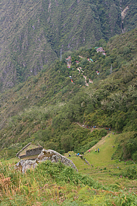
From the stairway we could now see our campsite perched on the hill in small clearings in the jungle in Winaywayna. It was still a fair way down, but Wilbur pointed out where our tents had already been pitched. The porters were very fast and organised. We had the bottom campsite with all our tents pitched in a row. A row of pylons crossed the camping area coming from a hydro electric power scheme unseen no doubt not too far away.
Beyond the camp was a hidden gully, and beyond that the steep mountainsides were covered in grass and scrub, so this must be near the end of the forest. There was a large slip in the distance reminding us of a severe storm that had struck at the beginning of the year closing the trail resulting in all the trekkers and porters having to be evacuated by helicopter. Fortunately we were blessed with better weather.
Intipata Farmhouse |
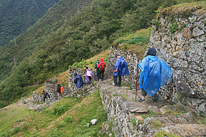
We continued single file following the rest of the way down the stairs. They were still in very good condition, but they were a little overgrown having grass and other weeds growing between the irregular joins.
Once we reached the bottom we passed the small triangular building that would have been a single house for the farmer or even a crop storage building. The building was atop a relatively wide terrace, but the slope dropped very steeply below into the forest.
Intipata |
The track heading towards the camping ground passed some small bell bottle flowers too brightly orange to appear natural, and numerous ferns. The standard of the track seemed to drop off a little with the stones being replaced by gravel as we seemed to go off the main stone route going moderately downhill towards the camp.
We arrived at a small greenish grey building with a sign saying massages were available at what I thought was a rather expensive price. We turned off just before the building and proceeded down the hill down a narrow track for a few terraces until we reached our terrace. Once more our porters stopped what they were doing and gave us the standing ovation. The terrace was about three metres wide and perhaps eighty long. It was curved into a slight gully. Most of if was covered in trees on both sides.
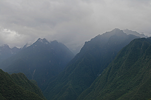
Stormy mountains |
The first two tents were the two big blue ones that we had used for meals and for cooking. The dining tent was at the front with the preparation one behind.
A very narrow track at the edge of the steep drop gave access past the two tents to all our other tents. All the double tents were next, and finally the two yellow tents for Marissa and I were at the end. I walked all the way to the end and to the furthest tent.
It was a bit of a precarious walk to my tent along the very narrow trail passing all the other tents, but it was well worth while. Most of the other tents had their view blocked off by thick vegetation. The last three tents, including mine, had a spectacular view across the river. The only potential issue was from here I could see it was a precipitous drop of about five hundred metres into the river. Thank goodness I’m no sleepwalker.

No details are missed! |
The view was of the forested mountains towering precipitously above the river into jagged peaks. Some were a little higher than our campsite, and the ones progressively further behind were steeper and steeper. The rain had stopped falling here, but it was obviously still raining on the other side of the river. The mountains nearby were green, whereas the more distant mountains faded into a misty bluish grey colour. Thick fog clung to the higher peaks that I could see, adding to the mysteriousness of the scene. To the left on this side of the river looking up I could see the fields of Intipata against the otherwise unbroken lines of forest. The only thing unnatural here were the pylons and their cables stretching steeply over the trees perhaps just thirty metres away.
Lunch |
I could see parts of the Urubamba River below, and could just hear the roaring of the cascading water. I could also just hear the sound of a train crawling down below taking tourists up to Machu Picchu still hiding behind the other side of Machu Picchu Mountain, now dominating the left hand landscape downstream.
I unzipped the tent and unpacked as the sky suddenly cleared around us letting the sun shine through into the valley. It was still raining up in the mountaintops though, as mountains are good at attracting cloud. Then we all edged our way back to the dining tent and had lunch.
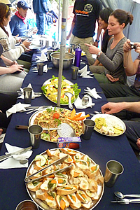
As usual the dining tent was set up with the blue Intrepid table cloth and a folded serviette with a metal fork and spoon, all professionally laid out in a manner you’d only expect in a good restaurant. Once more we were transferred from the world of tired legs into gourmet dining. We were all in quite high spirits, perhaps because there was no more hiking to do today – apart from a small side trip this afternoon.
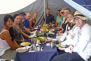
Lunch |
We started with a yellow vegetable and rice soup. This was followed by platters of food. Ricardo the chef amazed me. This was our third day of hiking, and still he was delivering fresh food from the backpacks the porters had been carrying. There were interesting tiny half buns with avocado and pumpkin on them. The next tray had fried rice with several vegetables intricately carved into complex floral designs. The next plate had a lettuce and egg salad, also very intricately presented. The final platter had olives, cheeses, and vegetable nibbles. It made for a very nice meal by any standards, and absolutely exceptional for a meal that had been carried almost a marathon distance over some of the world’s most rugged mountains.
Once lunch was finished, we relaxed. The porters were having a lot of fun now and one got pushed over the edge and slipped his way into the vegetation below. They all had a good laugh about it, not that I was sure what the joke was about. Obviously these guys are very tough.
The sunshine was short lived though. The clouds came back over and we had a couple of brief rain showers whilst we relaxed.
<< Previous | Next >> |
|
||
About this Page
|
||
|
|
|
Where is Walkabout Jeff? |
|
|

|
|
What is happening in Walkabout Jeff's hometown?
|
|
|

|
|
Who is Walkabout Jeff?Any normal person's idea of going out involves going to the local pub for a drink with a few mates. Walkabout Jeff isn't normal.
|
|
|

|
Follow Walkabout Jeff |
|