--- Archive files ---
Home > Treks > Inca Trail > Day 5 > 5.6 |
Forever Young
ONCE rested, we went up to the building in the middle of the afternoon. It was a rather crude hall with a restaurant where you could buy food and alcohol and even have a (rather expensive) massage.
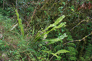
Fern beside the trail |
Wilbur had earlier told me there was a place here where I could get camera batteries charged. I had been very careful up till now with conserving battery power, but was getting concerned now that they were starting to run low and that I would have to be very conservative when going through Machu Picchu though, and I was already down to the last of my three batteries.
I found the stall in the main hall where a middle aged lady took my battery and charger, and hooked it up to a power board. Luckily I had my Australia to South America pin adapter with me. She charged for a rather expensive five dollars for the privilege. Then again there was nowhere else around here that had an electricity supply, so why not take advantage of your monopoly? Anyway having an empty battery charged will set me up really well for photography tomorrow when we arrive at Machu Picchu.
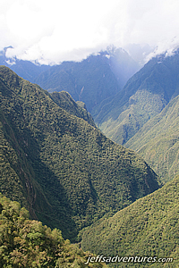
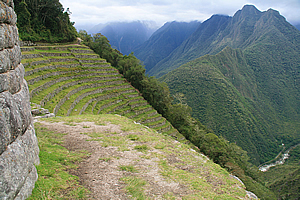
Looking towards Machu Picchu |
We walked around a balcony along the edge of the building seeing people there drinking beer from the small bar. Unbelievable I thought. There were the two bogans who I had recalled seeing at our lunch stop yesterday having a drunken swim in the stream.
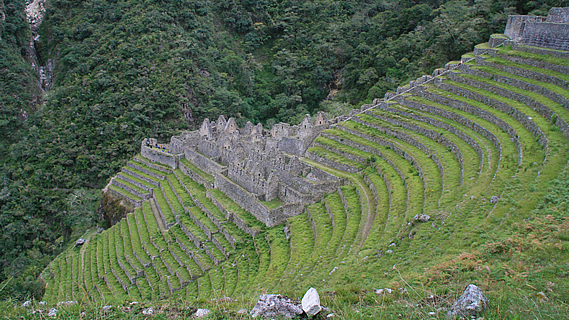
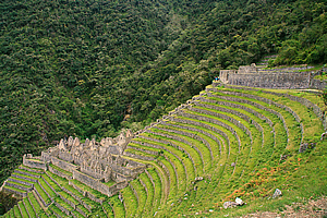
The rest of the group arrived and Wilbur led us out the other side of the building where we walked along a level stone path. On either side were numerous variegated leaf birds nest ferns in the undergrowth. We followed the dark forest for about five minutes before it suddenly cleared revealing the huge ruin of Winaywayna
I had not seen a ruin this big before – except perhaps Patallacta from up the hill on the first day, but that had been quite some distance away. With this one we were walking right into the midst of it.
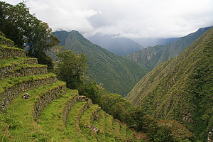
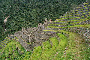
There were numerous terraces going in an arc across the gully to the next spur up the forty degree slope. Each terrace was almost perfectly flat faithfully following the contours of the hill. At the far end on the spur was the remains of a village divided into two sections. A small group of buildings stood at the top of the terraces, and a much larger group of stone buildings occupied the bottom, with a flight of stone stairs connecting them up the many terraces. The upper buildings seemed to have flat roofing whilst the lower buildings had steep gables. Beyond the village was a forested gully. The slope continued upwards a good five to seven hundred metres up to the ridge we had climbed over in the last pass this morning. Below us we could hear the faint roar of the river and the occasional train full of tourists meandering its way up to Machu Picchu.
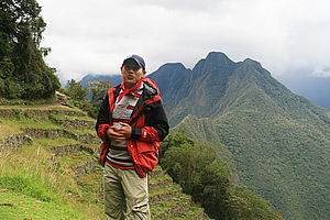
Carlos talking about the history of Winay Wayna |
We walked across the terrace towards the upper village. The terrace we walked on seemed to be a main route, wider than the other terraces below. There was a two to three metre high wall to the right holding up the next terrace above us.
Once almost reaching the stairway between the two parts of the village, we all sat down and Carlos explained the history of the place. We were happy that Wilbur wasn’t doing the presentation. By now we had established that whenever Wilbur does a speech, rain or hail falls from the sky. Perhaps he was an Incan rain dancer. Carlos apparently wasn’t as jinxed as it had by now stopped raining.
Terraces of Winay Wayna |
Carlos did a fantastic job in his presentation especially as his English was still very limited. He explained the village’s name Winaywayna means “Forever Young”. This was actually a variety of pink orchid that grew here. He described how the terraces each had their own microclimate and how the farmers would plant certain species in different locations based on the climate. We all gave him a round of applause as he had done a fantastic job despite his poor English.
Carlos then let us go to have a look at the ruins taking as long as we needed as the campsite was only ten minutes away. I went uphill to look at the round temple before heading down to look at the residential village.
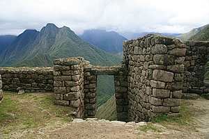
Entrance of the temple |
I walked around the terrace before heading up though and saw a porter from another group fast asleep on the grass, tired from three days hiking carrying twenty five kilogrammes some forty kilometres at high altitude. He certainly needed the rest more than I did, so I left him there and headed up the short set of stone stairs to the village temple.
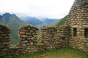
The entrance to the temple was a staircase going through an enclosed stone doorway. A large slab of rock perfectly shaped into a lintel closed off the top of the doorway. The stairs were perfectly locked in place as if laid just yesterday. It was hard to believe this village had been built five hundred years ago.
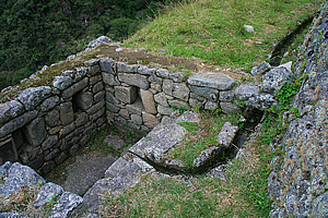
The fountain of youth |
Once up in the temple, I looked around. Like most Incan temples, this one was round. It had numerous windows in the rock wall. The tops of the windows were narrower than their bottoms. Behind the temple were a few square buildings with small square windows, and behind that were about ten more layers of terracing.
Looking down towards the residential village, I could see that it was quite narrow extending out onto what had been a flat terrace jutting out over the gully below. This made the village area relatively long and narrow.
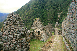
Residential Area |
Amy, Amanda and I took pictures of each other before we plodded down the steep stairway towards the village area. Beside the staircase was a number of small buildings with a trickle of water running down between each building. Perhaps this was the fountain of youth – after all they call this place “Forever Young”.
“Forever Young” actually refers to a variety of orchid that grows around here. The rainy season hadn’t started yet, so it was far too early to see it blooming yet. It would have been great to have seen the orchids here, but that would have most likely been at the expense of the amazing views I have had of the mountains throughout most of the trek. At these altitudes it would have been so easy to have been completely enveloped in cloud.
Residential Area |
There was an exit going across the stairway at each terrace level. I realised this was the irrigation system they had built to water their crops. There would have been more water coming from the gully running down here, and someone would have controlled some gates that were no longer here to ensure each layer of terracing was getting enough water from the fountain of youth. Perhaps I should have drunken some.
The houses were all very close knitted together in a layout similar to a modern townhouse complex. From there you could see all the terraced fields. It would have been pretty amazing here when the village was in full swing with vegetables growing on all the terraces, and with the amazing views of the valley and mountain from their homes. The village area was by no means flat, so there was a maze of stairways between the different buildings that would be easy to get lost in despite the very small size of the village. It would have been rather crowded living in this village, though I have no idea what the population of this village would have been.
Terraces |
Looking up from the village, I could see the terraces immediately above me rotated in a dome shape around the contours of the ridge all the way up to the temple.
The fields of Winaywayna would have produced enough crops to support a reasonable population of perhaps thirty to a hundred people, but I imagined a lot of the produce from here and other farm areas carved into the mountainside would have gone to the much larger Machu Picchu city which apparently didn’t have enough fields to support the population it would have accommodated.
Residential Area |
Most of the buildings here had small windows. Assuming every building was covered with a thick layer of thatching, the houses would have been rather dark and claustrophobic. The houses next to the edge of the main valley had larger windows in their walls to give their residents spectacular views across the valley. Perhaps these had wooden window shutters to prevent storm weather from getting in. As in the other ruins I had been to, the rocks were perfectly jointed together, very skilfully crafted.
From the bottom of the village a very steep stairway continued straight down the mountain to the lowest terraces to the forest below. I didn’t go down there.
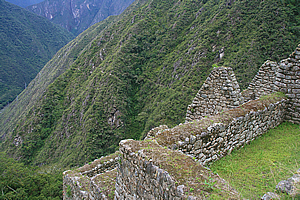
Some of the walls were off-plumb, now leaning over from hundreds of years of sitting on uneven surfacing millimetre by millimetre sliding down the steep mountainside under the strain of gravity. Despite that all the walls seemed to be standing solid. There were some rocks that were sticking out, or hollows that indicated these were used to hold up timber logs supporting the thatching perhaps.
The cloud was beginning to lower onto the top of the mountain directly opposite the river. That was a shame. It was such an attractive mountain. The mountains behind it were all covered over as well, so the view wasn’t as dramatic as it had been earlier today. It’s amazing what a difference it makes when jagged peaks are concealed.
Residential Area |
The tops of the stone walls were filled with sand and soil, and appeared very flat. I was amazed there was almost no vegetation growing there apart from a flat mat of some sort of ground cover, so this area must be very frequently maintained. To my surprise the grass here was pretty short. It wasn’t a mown short, but had the slightly erratic look of having been grazed, indicating there must be some alpaca or llama that graze here. I hadn’t seen any though.
From the end of the village I could see a small cascade going over a huge boulder in the bottom of the gully. The rest of the gully was too heavily forested to see the water that I could hear bubbling downhill. This must be the source of the fountain of youth.
Instead of heading up the stairs, I walked out along one of the flat grassy terraces. It made for very easy walking in the otherwise very steep terrain. The view back to the village was fascinating, giving the impression of a religious nave style, but not as good as the view looking down from the upper terrace we had arrived along. Michael and Julia had taken the stairs down from the village that I had not taken. Everyone else had by now left returning to the camp, no doubt still tired from the three days hiking we had just done.
Winay Wayna |
There was quite a stark difference between the lush yellow green grass in the foreground, the greyness of the buildings and terrace walls in the mid distance, and the bLuish grey green of the forest in the background perfectly framing the village.
I returned to the stairway and walked up to the main terrace, then back along the track through the forest to the building. Michael and Julia were about five minutes behind me.
Five minutes later I returned to the restaurant building where I saw the rest of the group sitting around drinking beer with the two bogans we had seen earlier. They were from Mackay, about a thousand kilometres north of Brisbane. I had no idea what they were saying as they were speaking the slang and drunken nasal twang of the working class rural Australian, but they seemed to be recounting some stories of wild boar hunting somewhere inland of Mackay (a city about a thousand kilometres north of Brisbane) where they lived.
I entered the dining hall to pick up my battery charger. There was a different person at the office now and it took quite a while for me to communicate that I had a battery that was being charged. She said there were no batteries getting charged here. Gosh. I had just taken a lot more than my original quota of photos at Winaywayna on the understanding that there was going to be a fully charged battery to take photos galore at Machu Picchu tomorrow. If we couldn’t locate it, I was going to be screwed with being rationed to about fifty photos over the entire day. That was far too tight for exploring one of the world’s most amazing archaeological sites.
Finally after much rummaging around she did manage to find my battery about a metre away from where she was sitting still being charged under the paperwork. Fortunately the light was green now indicating it was fully charged. What a relief.
I was pretty tired by now so I decided to return to the campsite and rest at my tent admiring the spectacular view from the entrance until dinner time.
<< Previous | Next >> |
|
||
About this Page
|
||
|
|
|
Where is Walkabout Jeff? |
|
|

|
|
What is happening in Walkabout Jeff's hometown?
|
|
|

|
|
Who is Walkabout Jeff?Any normal person's idea of going out involves going to the local pub for a drink with a few mates. Walkabout Jeff isn't normal.
|
|
|

|
Follow Walkabout Jeff |
|