--- Archive files ---
Home > Treks > Inca Trail > Day 6 > 6.5 |
We are down Here!
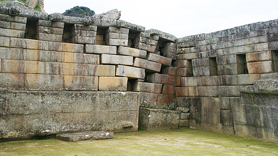
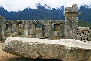
UPON leaving the Temple of the Sun, we climbed further along the narrow stairway streets resembling those of Cuzco, passing under perfectly constructed doorways resembling those in Egyptian tombs. This was part of the Temple of the Three Windows. There were stone figures representing the three levels of the Andean World – the Hanan-Pacha (the sky, or spirituality), the Kay-Pacha (surface of the world, or materialism) and the Ukju-Pacha (the underworld, or inner life).
Temple stonework |
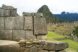
The walls around the obvious temples were even more perfect than brickwork, whereas the construction of the lesser buildings was somewhat more rustic with irregular rocks still perfectly joined together. Looking up the mountain, the grassy tops of the terraces were hidden from view, so it appeared to be one continuous rock wall as viewed from here. The ground was covered in compressed sand. I’m not sure whether it had been cobbled and worn out from the tourist traffic, or whether it had always been covered in compressed sand.
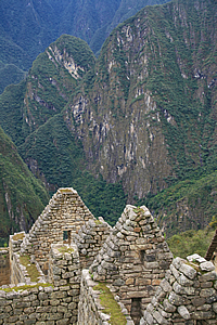
Houses perched on the saddle |
We reached an area with steep gabled roofing again, probably the emperor’s residence, along with the residences of the Amautas (the wise people), and the Nustas (the princesses). There was another fountain with a perfectly formed running water spring carved into the rock.
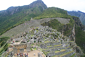
Once through there we began to ascend to a higher temple area – this was the Main Temple. Now for the first time we had a view over the Central Plaza, a large low area covered in grass with no buildings at all. On the other side was a low ridge with a lot of houses on it. This was the main residential area.
We followed the narrow track climbing towards the Main Temple. There where more houses perched on the slope below us. To our left was the quarry, where a jumble of huge boulders had been carved out of the solid rock but never used for the construction.
The track steepened as we continued heading up to the Main Temple. Some of the stone walls had moved with some of the blocks falling out or at least showing gaps where they should be pushed in. This had been caused by centuries of water seepage. It is not known which god this temple was used to worship, but historians believe it would have been the invisible chief Andean god Wiraqocha.
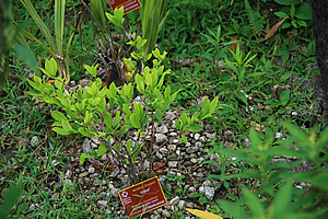
Coca plant |
We stopped at one point where Wilbur pointed out a Coca plant – Erythroxylon Coca, a small bright leafy shrub. This was the plant where Coca Cola and cocaine and various chocolates was made from.
Finally we reached the top of the Intihuatana Pyramid, containing a large courtyard and various temples.
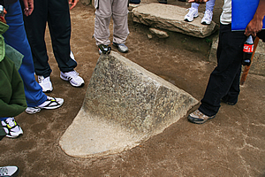
In the middle of the courtyard was another large stone set up as a huge compass. This was known as the Intihuatana Stone. It has been arranged to point directly to the sun during the winter solstice. The name literally means the hitching place of the sun. The Inca believe the stone holds the sun in its place in the sky. It is noted the sun casts no shadow when directly overhead at midday on 11 November and 30 January each year. It casts a long shadow on the southern side on 21 June, and a shorter shadow on the northern side on 21 December. It is therefore used as a calendar.
Temple altar |
Then there was a large boulder set up as a table. There were other large temple buildings of significance.
From here there are four mountain peaks at precisely the four cardinal points. The summit of Machu Picchu mountain is to one direction, the mountain behind the Sungate is in another, and there are two other mountains whose summits are in the other two directions. Between them these mountains point exactly to north, south, east and west.
Compass stone |
I also had a good view down the river, to where a small power station stood. That would explain the pylons passing the campsite yesterday, and following the track back on our first day.
I thought we were at the top of the hill, but there was another rise of a good twenty metres to go. We followed the narrow trail up to the very top to where we saw more temples.
From the top, there was a spectacular view back to the main city terraces up to the viewpoint where we had arrived, and up to the top of Machu Picchu Mountain. The mountain looked quite big now, totally different to the tiny mountain we had seen far below us this time yesterday.
Looking back over the city from the temple |
There was one upturned stone with a jagged edge that exactly matched a mountain on the other side of the river. Although the cloud had by now descended to below the jagged tops and we could not see this peak any more.
I took a photo back over the city towards the top of the mountain just as Luis and Carlos climbed up in front of me. They were both too low to be in my field of view, so they joked telling me they were down here. Very funny I thought as I photographed them laughing. I’m sure it was just a joke.
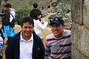
"We are down here!" |
From here we also had a clear view down to the residential sector. Wilbur did another presentation, this time referring to the map to jog his memory. There was another irregular shaped block of rock used for religious purposes no doubt.
We walked out of the top of the temple and saw a man with a surveying tripod, no doubt taking accurate measurements of the city as part of an archaeological expedition. I’m sure it would have been very difficult to work here with so many tourists around. We then followed the stairs naturally placed perfectly in between the giant boulders that held up the temple.
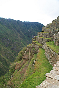
Precipitous sides of the city |
When we reached the large terrace at the bottom of the temple, we stopped and Wilbur said this was the end of the tour. We were free to explore the rest of the city as we wished. There was a large flat area below us, and beyond that was a wall holding up the next level on the other side. This side contained all the residential houses. It was like a compact townhouse complex extending along the side of the mountain. By townhouse complex standards it was very long. It could have been any ancient townhouse complex but the one distinguishing factor was it was up here on the saddle of such a precipitous mountain. That made it incredibly impressive. At the left end of the residential area was a couple of large A framed huts at the entrance to Huana Picchu. On either side of the terrace was a sheer drop into the river.
We briefly rested under the huge boulder before Wilbur let us all go to start exploring at will – even though we really had very little energy left after our four day pilrimage along the Inca Trail.
<< Previous | Next >> |
|
||
About this Page
|
||
|
|
|
Where is Walkabout Jeff? |
|
|

|
|
What is happening in Walkabout Jeff's hometown?
|
|
|

|
|
Who is Walkabout Jeff?Any normal person's idea of going out involves going to the local pub for a drink with a few mates. Walkabout Jeff isn't normal.
|
|
|

|
Follow Walkabout Jeff |
|