--- Archive files ---
Home > Treks > Inca Trail > Day 6 > 6.6 |
Residential area under the Mountain
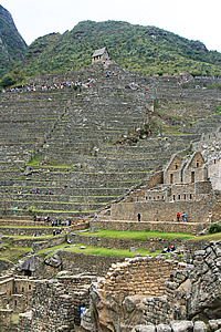
I CROSSED the large lower terrace between the two sections of the city. The walls of the terraces here were in straight lines and perpendicular where needed. They still followed the contours, but in rectangular sections. There were a few wooden staircases set up in some of the corners as there were no stairs constructed by the Inca.
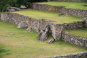
Terraces of the common area |
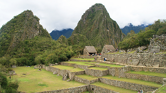
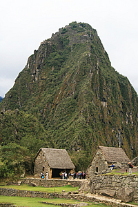
I worked my way towards the two large A framed huts at the entrance to Waynapicchu. A small wooden fence with thatching on top blocked off the sacred mountain area. I wondered where the girls were now, whether they had reached the top. Shame they hadn’t had the time to explore the city.
About half way up the face of the sheer rock face was a cave. This cave contained the temple of the moon. It was an elusive compliment to the temple of the sun.
Entrance to Waynapicchu |
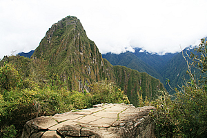
I explored the large A frame huts which were open picnic areas before heading over a very rough cut track over the partially carved stones towards the residential area. This track was a lot more natural than anything I had walked on over the entire trail. At the top of the track was a natural flat rock from where I had a view of Waynapicchu mountain without any buildings in the view. It looked just as it would have when the Incan emperor was exploring this site to build his amazing retreat.
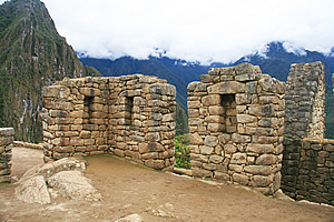
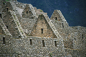
From there I walked through the Residential District, otherwise known as the Popular District. I looked in all the small townhouses where the farmers and servants lived. Some of these houses had spectacular views of the mountains being at the edge of the hill. The houses were all very close together and were now devoid of the thatched roofing that had protected the residents from the elements.
Waynapicchu |
The buildings were mostly in very good condition, but there were still big piles of rock rubble lying around on the grass inside the unroofed buildings. The windows to these houses were small and wider at the bottom than at the top in the same fashion as the houses in the lower part of Winay Wayna. Like the temples in the other part of the city, the houses were built perfectly around the huge boulders that had originally occupied the area when it was first constructed. The residential area was rather like a very compact townhouse development now so common in cities around the world. Of course the walls of modern townhouse complexes wouldn’t have anywhere near the strength as the half metre thick walls of this village.
Residential houses |
There the workers who maintained the emperor’s retreat city. They maintained and worshipped in the temples as per the Incan religion. They also tendered the fields, but archaeologists have calculated the agricultural areas here would not have been sufficient to have fed the people here. They must have imported a lot of their food from the farms further along the Inca trail, and no doubt much of it had to be brought in from the farms between Ollantaytambo and Cuzco.
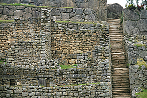
Stairs climbing the walls |
There was nothing particularly special through here, apart from the views out to the mountains on one side and to the rest of the city out to the other. There was one area known as the group of the three doorways – a very significant area culturally but not standing out as did the temples of the other side of the city. As I looked down the formidable hill immediately beyond the houses, the further down the more ruined the city became until the terrace walls were no more than piles of rubble.
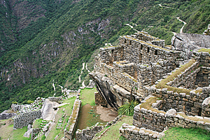
Overhanging house |
One house stood on an overhanging rock solidly planted into the ground. The rock came back at about a fifty degree angle putting about half of the house on an overhang. There were a couple more houses below this one, then the steep cliff drop to the river thundering far below.
As I started to approach the end of the village, I could see the amazing geometry that covered the entire city. This would have been designed and built by very intelligent people who would have seen the small saddle atop the precipitous mountains in the jungle and had somehow visualised the amazing retreat that it would become. Planning and undertaking such a project would have been very daunting.
Temple on an overhang |
I passed another stone building perched atop another overhanging rock, but this one stood several metres above the rest of the village. It would have been a scary place to have been during a storm. This was the temple of the condor, containing an altar shaped like a condor’s head. Under the temple was another burial area with strange shaped carved stone shapes no doubt used in the preparation of the corpses for burial.
I then passed a prison. The jail cells were set into the ground. They did not have any roofing, so I could see the cells below and the maze of underground dungeons linking them. It was hard to believe though such a tranquil retreat would have any need for any jail.
Prison |
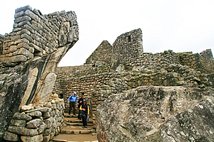
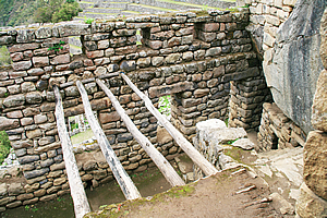
I reached the end of the residential area and crossed over the main square, which no doubt would have been used as markets. I returned up through the main temples, seeing more working irrigation channels.
Finally I reached an area of the city where three of the buildings actually had thatching on the roofs. I entered two of these, having just caught up with Amy, Hannah and Kathleen, so we explored them together.
The buildings were rather small and claustrophobic, each containing a single four by seven metre room with a high gabled ceiling. They were quite dark inside, and I imagined they would have been darker still with doors installed. That is if there were doors at all. They would have been used as the storage buildings for the supplies that had to be carried in to supplement what they grew here.
Looking back to the main view point |
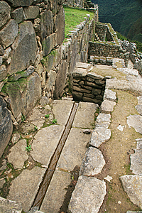
Perfectly preserved irrigation system |
The roofing consisted of fairly thin logs following the direction of the gables at either end peaking along the ridge of the roof. Horizontal cross members held the logs in place in a solid triangular shape. Above the logs were thinner log rafters which held up the thick brush thatching.
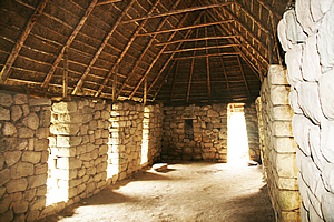
House with a thatched timber roof |
The others walked out to a nearby terrace to rest. I still had some energy left, so I walked up towards the top to get some more shots. I reached the big flat rock and took a few photos. I noticed now the cloud had dropped quite significantly so the clear view of the jagged mountains in the backdrop was no longer there. Drat, I should have gotten this shot on the way down from the top earlier when the cloud was clear of the peaks.
Otherwise the view was amazing, with getting more of the residential area than at the main viewing platform. Though being high up didn’t really capture the steepness of the terrain as had the shots from within the village.
Houses |
Then I continued up the steep stairway towards the guard house at the top standing in solitude above the rest of the city. The building was locked and seemed to have a lot of people around it. From there looking through the mountains upstream thick clouds were bringing dark rain that obscured the steep slopes. It looked like it was going to be raining here within the hour, so it was time to start making tracks.
I walked back to the viewing platform, to take a few more shots of the city with the small mountains still forming a great backdrop behind it, and of course the brightly tussled Llamas feeding up there. Exhausted, I headed down to where the girls were still resting. We took a few photos as the cloud quickly descended before returning towards the entrance building.
<< Previous | Next >> |
|
||
About this Page
|
||
|
|
|
Where is Walkabout Jeff? |
|
|

|
|
What is happening in Walkabout Jeff's hometown?
|
|
|

|
|
Who is Walkabout Jeff?Any normal person's idea of going out involves going to the local pub for a drink with a few mates. Walkabout Jeff isn't normal.
|
|
|

|
Follow Walkabout Jeff |
|