--- Archive files ---
Home > Treks > Inca Trail > Day 6 > 6.7 |
Town at the Bottom of the Chasm
IT WAS time to meet the rest of the group so we reached the entrance only to find a very long queue for the buses to the bottom of the hill. It went down the steps then snaked its way around to the bus stop and there weren’t many buses around. Most of the other tourists there were middle aged to elderly fresh and clean and a bit unfit. In stark contrast were us who haven’t washed ourselves properly in the past four days having hiked the length of a full marathon over very mountainous country. We hadn’t noticed ourselves looking increasingly ragged, but now against these other tourists we stood out like sore thumbs.
A bus arrived and we managed to advance a little up the queue. Behind us the queue was getting longer faster than the buses were able to shorten it.
Finally we reached the front off the queue, and a bus arrived. We climbed on board with Amy sitting next to me and away we went.
Aguas Calinentes |
The bus slowly descended the hill, going across the steep slope going around hairpin bend after hairpin bend in the bromeliad and moss covered gnarly cloud forest. We passed precariously close to a couple of other buses going the opposite direction up the hill to pick up more tourists.
Finally we reached the bottom and crossed a narrow one lane steel bridge over the cascading Urubamba River brown with heavy rainfall at a low two thousand metres above sea level. The air felt so thick down here after spending nearly a week at high altitude. Then I realised it will be another week before I will drop below this altitude again. From here we were heading up towards three and a half thousand metres tonight, and remaining at over three thousand metres until I fly to Chile in about a week’s time.
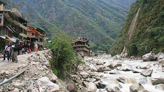
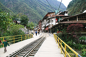
Once across the river the bus followed a gravel road along the bottom of the narrow valley. There was hardly any room yet there was also a railway line. Precipitous cliffs towered impossibly high above us echoing the roaring river loud enough to hear even from inside the enclosed bus. It was already hard to believe that just this morning we were hiking high up in amongst these precipitous obelisks.
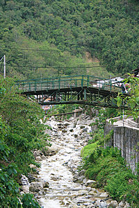
Bridge into town |
The bus rode around the bottom of the gorge until we suddenly saw ahead of us a town perched against the edge of the thundering river come out of nowhere. The brown water pounded over the huge white granite boulders carving its way downward into the steep mountain. Clearly glaciers have never been here before.
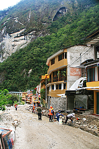
The bus dropped us off in the middle of the small town of Aguas Calientes, with two storey buildings lined up on either side of curved paved streets at the bottom of the precipitous mountains. The mountains stood so steep and high, they looked as if they would collapse at any time. The road had railway lines in the middle of it with small trains shunting along it and small carts negotiating between them. The street was otherwise paved, but most of the paving was getting dug up and replaced. Obviously they don’t make paving here like they used to back in the Incan times.
We walked along one of the streets until we reached a small pizza place opposite the Banko de la Nacion (a bank) where Luis and a couple of the others had already arrived. We walked up to the upper level, but decided to return to the ground level and get the big table near the front entrance. It will make us easier to find anyway.
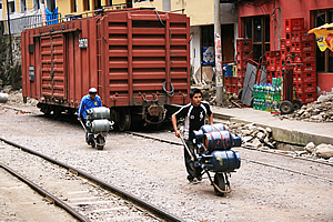
Locals delivering gas bottles |
We sat down at a table at the front of the charming brightly coloured restaurant and ordered pizza.
Everyone else arrived in dribs and drabs thanks to the regular bus service, with Marissa arriving last having been a bit confused with whether to get the bus or wait for us. We all ordered rather unhealthy pizza and ate it for lunch. The others seemed to like such unhealthy food a lot. I had hoped for something a bit more nutritious following four days of hiking. At least this was a lot better and faster than the one we had at Ollantaytambo the night before we started the hike.
As we ate the occasional small single carriage train passed outside on its way to the final station at Machu Picchu. A couple of small men passed wheeling four large gas bottles each in wheelbarrows. A small dump truck went past with four road workers standing in the dump tray. Then a large blue train slowly went past. This was a first class carriage said Luis, where tourists pay over five hundred dollars to travel in luxury.
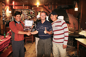
Receiving my certificate from Wilbur and Carlos |
Once we finished eating, Wilbur and Carlos appeared and presented each of us with a certificate of achievement. I had my photo taken with them to add to the one Ryan had presented of my climb of Mount Kinabalu earlier this year.
Following the presentations, we had a walk around the charming village. I walked back downstream to where I got a very nice view of the river. The floods at the beginning of the year had caused a lot of damage here and part of the road was still washed out. In January sudden flash floods had severely damaged the railway and some of the roads (hence the resurfacing of cobblestones outside the restaurant) and had left over two thousand people stranded. The tourists in the area had to be evacuated by helicopter.
The river must have flowed incredibly fast during the floods. Today the water level would have been a bit above normal, but it was tumbling very swiftly over the giant boulders. There must be a lot of uplift going on here for such a big river to be running so swiftly between such high vertical cliffs on either side.
Bridge between two markets |
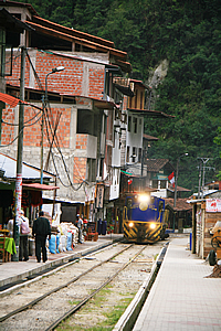
Train passing through town |
I returned to the village and continued following the main road crossing a couple of large streams which tumbled down large rocky steep riverbeds with large stone retaining walls on either side holding up buildings. This was what I would have expected for a village perhaps somewhere in the depths of Switzerland.
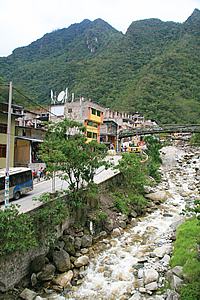
Stream rushing through town |
Aguas Calientes would get very little sunlight at any time of year thanks to the precipitous mountains in all directions around the gorge, and due to all the cloud here. Thankfully we were well in the tropics, so it would never get too cold here like it does in similar places I’ve been to in New Zealand in the South Island.
As I continued walking up the road, a train slowly approached from behind. The road was quite narrow, so I had to go right over to one side as the train passed. Then I realised I was at the edge of a large market place. I quickly walked through it not expecting to buy anything. The markets mostly sold brightly coloured alpaca clothing. The market followed the side of one of the big streams. I reached the end of the market and crossed a footbridge across the stream and walked down the other side to an alley way that led into a small square with a few statues of early settlers here.
There I met Michael and Julia who were also out for a walk. We returned to the restaurant and collected our bags to walk across town to catch the train.
<< Previous | Next >> |
|
||
About this Page
|
||
|
|
|
Where is Walkabout Jeff? |
|
|

|
|
What is happening in Walkabout Jeff's hometown?
|
|
|

|
|
Who is Walkabout Jeff?Any normal person's idea of going out involves going to the local pub for a drink with a few mates. Walkabout Jeff isn't normal.
|
|
|

|
Follow Walkabout Jeff |
|