|
||||||||||||||||||||||||||||||||||||||||||||||||||||
|
||||||||||||||||||||||||||||||||||||||||||||||||||||
Home > Treks > Australia > Sunshine Coast Hinterland > 2 |
||||||||||||||||||||||||||||||||||||||||||||||||||||
|
||||||||||||||||||||||||||||||||||||||||||||||||||||
Introduction to today's journeyTraveller, there are no paths. Paths are made by walking. - Australian Aboriginal saying. Today's trek continues along the ridge from Thilba Thalba before descending back into the valley crossing the creek at Gheerulla Falls. From there we head downstream a short distance before returning up the hill to stay at Ubajee Walkers' Camp. Today's JourneyDistance trekked today: 10.2 kilometres. Total distance trekked to date: 25.7 kilometres. RAINDROPS were still falling from the trees when we got up in the morning. The insides of our tents were dry but everything outside was very wet from the overnight rain. The sun had long risen but the thick cloud cover made for quite a dull morning.
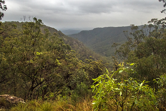
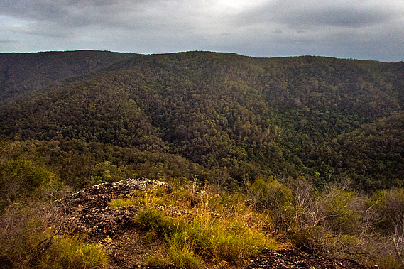
I quickly walked down to the lookout. The view down the valley was clear with the thick cloud hovering clear above the ridges. The air was a lot cooler this morning than it had been yesterday. Fortunately there was little wind even up here on the ridge. From here we could see down the Mary Valley as we had done yesterday. In times past the valley had been home to the ten Aboriginal clans of Kgippandingi, occupying the dense jungle that once covered the Mary Valley before the white people came and cleared it into farmland. These were the most local clans who had the shortest distance to travel to the corroboree at Baroon. The tribes integrated and traded well, having a common language Kgaw’bpidhai’i meaning “nowhere, but of everywhere” indicating the language was not owned or had been originated by any particular clan. This may be one of the earliest languages to evolve into the five known original dialects of South East Queensland.
The ten clans are commonly known as the Ka’bi, but each clan had its own identity and culture. Little is known about these cultures as few of the early researchers ever ventured into this remote area. There were ten clans. The Kyi’kgami were the Cockatoo People of the Woolooga region near Gympie (half way down the Mary River). The Kgai’ya were the scar makers of the Widgee and western range regions west of Gympie. The Kgu’li were the bees wax hunting people of Pie-Eel Creek south west of Gympie. The Kga’pbala were the possum people of the Imbil, Kennilworth, and Conondale areas of the valley and hills to the west of here. The Kgai’yani were the forest dwellers of the ranges west of Imbul and Kenilworth. The local Kgung’wuri were the river fishermen of the upper Mary Valley-Obi-Dhawalli regions of the streams this track explores. The Kguala’wani were the koala hunters between six mile creek and Mary River south east of Gympie. The Kgu’thari were the club hungers of what is now the Gympie/Deep Creek regions. The Kgut’dhirri were the iguana peoples of the Gunalda-Curran’neerdie regions north west of Gympie. The Kga’kgari were the cannibalistic peoples of the Theebine, Gundiah and Bauple regions further to the north west of Gympie.
The valley had originally been known as the Monoboola River. It had been renamed the Mary River When Andrew Petrie travelled up the coast in a flimsy craft in 1842 confirming the discovery of Wide Bay. Governor Fitzroy ordered the valley to be renamed the Mary after his wife who was tragically killed in her carriage at Parramatta west of Sydney when the horse bolted. The town of Maryborough near the mouth of the river was established shortly afterwards. The ridge upon where we were staying marked the start of the Kgung’wuri clan, the keepers of these remote valleys of the upper eastern tributaries of the Mary River, known as the fisherman tribe due to the abundance of fresh water fish in these rivers.
All ten clans were wiped out by around 1885. The few remaining people were elderly and were sent to Cherbourg inland to the north west or worked as servants in the farming stations, the last of the remaining clanspeople died in the 1920s. The clans that had once inhabited these valleys have now gone for good. The dense jungle once occupying the entire Mary River catchment has been completely wiped out and replaced with modern pastures standing bright green in the distance under overcast skies. Heavy rain would have fallen on some of the Blackall Range overnight, but this area had missed most of the downpours.
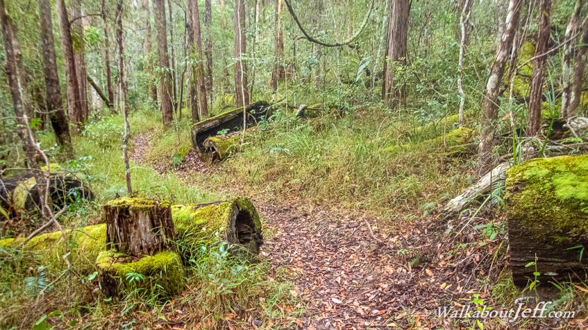
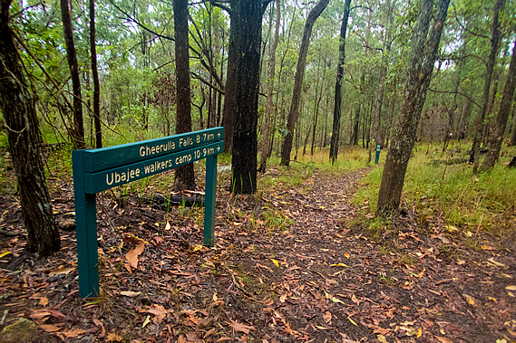
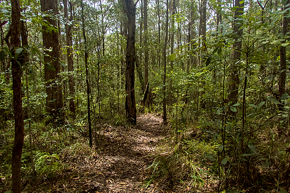
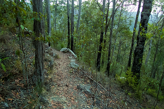
With everything outside being rather wet it was a bit of a slow start to the day, but eventually with breakfast finished and everything packed up we were ready to leave, to continue following the ridge towards the completion of the circuit at Gheerulla Falls about nine kilometres away, expected to take about four hours following perhaps one of the paths of the early tribespeople not hiked on by original inhabitants for a hundred and thirty years. A dirt road led into the camp ending at the picnic tables. This was a service road for the campsite, but the track dropped off on either side of the campground along a fairly narrow path. The track began along the top of the ridge, but gradually dropped off into dense forest similar to that along Leafy Lane, except with a lot more gassy undergrowth. The trunks were blackened from past a firestorm, but the grass was well established, so the last fire through here would have been several years ago.
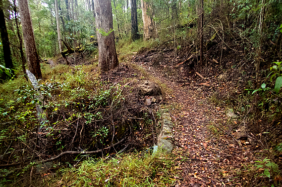
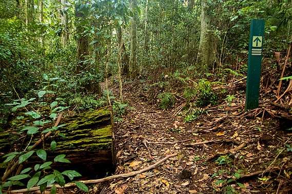
The rain had stopped falling by now, but raindrops were still dripping from the foliage of the canopy high above. The track maintained a fairly level grade winding out with the spurs and back in with the gullies. Moss covered the sides of the tracks and the logs of fallen trees, especially around the backs of the gullies. There were a lot of logs that had been clean cut with chainsaws. They were covered in moss, so they would have perhaps been cut down before the national park was formed, during the dying days of the forestry harvest around Mapleton, when they had cut down all the big trees and there wasn’t enough left to keep the industry going.
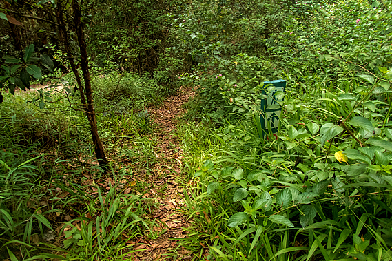
Bracken replaced the moss when the track approached the drier forest at the edge of the valley. At one point about half an hour out from the camp we reached a junction from where a side track to the left took us to the top of a low hill. There was a final scramble over rock through scrub to the top of a bluff.
When we reached the top a cliff face dropped down into the Gheerulla Valley. There were views across the forested valley to the rather flat plateau on the other side. The still valley sat silent under the thick layer of cloud overhead. From the lookout we returned to the track and continued heading through the forest. We could hear the occasional four wheel drive car travelling along a gravel road nearby. The undergrowth was too thick to see any signs of the road or the vehicles travelling in it.
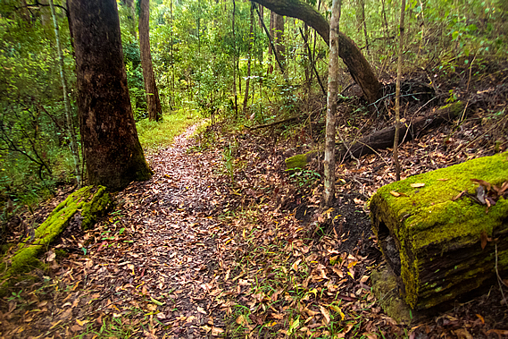
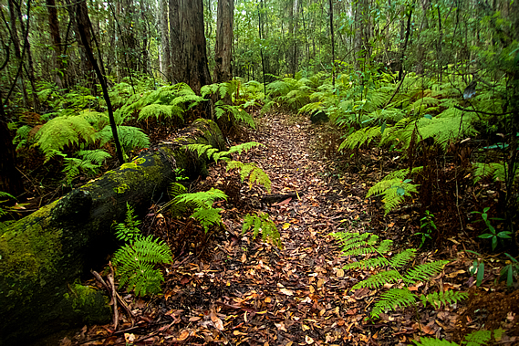
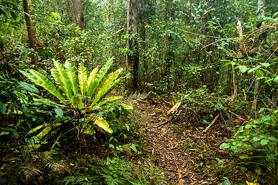
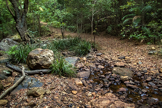
We reached a dry creek bed at the back of a gully. The map showed this often has flowing water in it, but being dry confirmed there hadn’t been much rain along this ridge overnight – most of it had fallen further north. This meant the Gheerulla Falls won’t be flowing much at all, perhaps just a trickle. Upon leaving the gully the track extended back out along the next spur, almost reaching the end when it quickly doubled back following the top of a low cliff giving a limited view of the valley. Once it had cleared the cliff the bush began to thicken, gradually increasing until it became rainforest with masses of piccabean palms. We crossed another two dry creek beds which obviously flowed following heavy rain.
We passed two solo hikers about fifteen minutes apart, both heading towards Thilba Thalba for the night, but they weren’t in the same group. Gradually the track turned southwards and through the dense rainforest we suddenly reached the gravel road.
The road descended moderately towards a saddle through the forest, but the track overgrown with broadleaf plants followed it on the far side, passing farmland briefly. Then the road dropped very steeply towards the saddle about two hundred metres below the ridge I had followed. The undergrowth quickly cleared as the track descended through open eucalypt forest nearly as steeply as the road. It would be quite a difficult road to drive along, but fortunately not too much rain had fallen so the road wasn’t too slippery.
The track followed the route of the original road the pioneers cut to reach the tall forests of the Thilba Thalba Ridge. The locals knew this as the “Hindu track”. It was a long descent going backwards and forwards around the trees. There were no steps making the descent rather slow. The trees would have been no more than thirty years old. Despite that there was a scattering of large chainsawed logs hidden in the scrubby undergrowth showing evidence this area was had once been cleared but had regrown. Following a rather slow descent along the steep track we reached the bottom where a small bridge crossed a dry stream before the track came out on the road just above the bottom of the saddle.
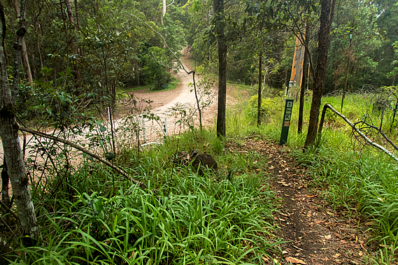
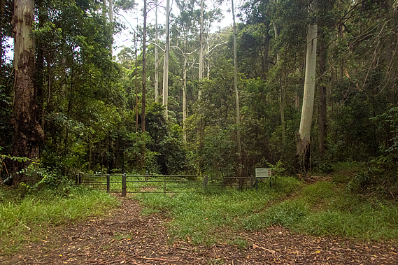
From the saddle the road ascended very steeply in either direction. The road continued heading towards Mapleton. This could be used as a short cut towards Baroon Dam, but we needed to follow the track to complete the Gheerulla Circuit and return up the hill to Ubajee tonight. That being said we will be crossing the road several kilometres away on our way to Flaxton Camp tomorrow. A small car park was on the other side of the road at the junction. From the car park a track headed down the gully passing the gate of a service road and heading into the tall schlerophyll forest of ghost gums and scribbly gums. After briefly resting at the car park where one car did arrive, then continued along the road, we followed the track.
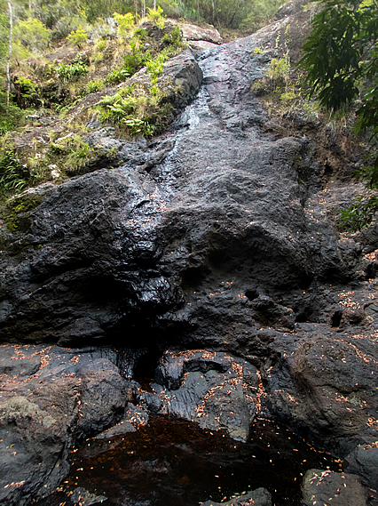
The track descended moderately along the service road above a dry creek bed for about a kilometre before I could see the Gheerulla Stream in a small clearing ahead. A side track turned off to the right though, heading upstream towards Gheerulla Falls. We took off our packs and followed the rather rough track following steps over the rocky terrain through thick rainforest. The stream was still a trickle, so there won’t be much water coming over the falls.
After about five minutes of scrambling we reached the top of a large outcrop from where we could see a dark pool about ten metres below and a large wall of rock towering about twenty metres above on the other side. A small trickle of water was running down the rock face. I then realised this was Gheerulla Falls. A small flat area was half filled with the dark tannin stained water which dribbled under a huge pile of boulders washed down from huge floods in the past. After a massive downpour the waterfall would be very spectacular and the pool would be full, but today it was only a tiny trickle going into a stagnant pool. We didn’t stay very long, instead heading down the route back to the main track.
Once we reached the main track we crossed the creek in a ford that didn’t have any concrete in it. The crossing was completely dry aside from the row of small puddles. Between the stones which made for an easy dry crossing. Once on the other side we continued along the wide dirt road for about two hundred metres before reaching the junction with the side track heading up the steep stairs to begin the ascent towards Ubajee. We had completed the Gheerulla circuit. From the junction of the Gheerulla Circuit we climbed the spur back towards Ubajee. From here we will be backtracking for the next four kilometres up the hill to Ubajee this afternoon, and then almost back to where we started tomorrow morning before turning southward to roughly follow the Blackall Range towards Baroon Pocket.
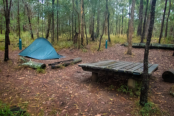
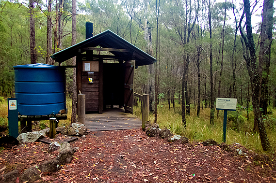
It was a steady climb, not steep like the ascent of Gheerulla Bluff yesterday, and certainly not as hot. The air became very humid and light rain began started to fall as we were traversing across a bluff along the track about half way up. Climbing through the gradually thinning eucalypt forest we eventually reached the lookout. By now the short-lived rain shower had cleared and there were patches of blue sky overhead. Almost at our destination we decided to continue to Ubajee to set up camp and return to the lookout later. We found a well worn short-cut track into the campsite. Our group was the first to arrive, so we set up our tents in two of the back campsites away from the toilet building. The toilet building was just like the one at Thilba Thalba set above the ground with a single pump toilet and a steep corrugated iron roof draining into a nearby water tank.
There were several circular campsites cut in the otherwise thick scrubby undergrowth. Each campsite had a low wooden table at sitting height for keeping stuff off the ground and for cooking. I picked one of the remoter campsites and the others picked the next one along. We all put up our tents as we had done last night. They were still rather wet from last night’s rain, but fortunately they dried out reasonably quickly under the sunshine. For many thousands of years the Aboriginal people travelled through the resource rich Blackall Range. Some lived on the other side of the range exposed to the prevailing south easterly winds resulting in higher rainfall. This suddenly fell apart in the late 1800s and early 1900s when the white settlers came cutting down the big trees for timber and clearing much of the land to farm. The Aboriginal people were faced with conflict with the new settlers. They were driven from the settlers’ land by gunfire, and died from introduced diseases that would eventually wipe out 90 percent of the population. They could no longer hike over these mountains to gather the food from the lands they had occupied for many thousands of years forcing them into starvation.
Most of the Aboriginal people who did survive the shootings, disease and starvation were rounded up and forcibly moved to missions around the Cherbourg, Cairns, Palm Island and Ipswich areas around 1897. They were detained in these areas working in forced labour and domestic servant roles. Fortunately this didn’t last for too many years. Many of the detained Aboriginal people were eventually allowed to return to their homelands to re-establish their traditional way of life. Although much has been lost, their culture and stories of this area have thankfully survived. The name Ubajee means “village”, perhaps as a reminder that the Aboriginal people did have their villages around here. That being said there are no records of people actually living here. They were walking tracks over the ranges, but no villages. They were all down in the valleys.
I couldn’t see any evidence of an Aboriginal settlement here at Ubajee. Any former village would be very hard to find. I have travelled through ancient civilisations where buildings and temples had been constructed from stone, and although abandoned for many centuries, they were still standing, even if in ruins, as clear evidence of their former existence. The Aboriginal people didn’t construct villages out of stone. They used the vegetation that was in abundant supply. If a village is abandoned, the thatched timber huts are quickly decomposed by termites and the trees grow quickly, hiding almost all evidence of their former habitation. I couldn’t find anything to indicate the Aboriginal people had ever lived here, in this place called “The Village”. Maybe this had been a village in the past, or at least a temporary camp for people hunter gathering in the Gheerulla Valley. The other possibility is the camp was named The Village in recognition that the Aboriginal people had lived in this general area and that their past village locations had been wiped from existence when the European settlements were built over them. All that being said, few Aboriginal people lived along the top of the Blackall Range on a permanent basis. Anyone found here would just be passing through due to the ongoing hostilities between the Kabi clans of the Mary River and the Undambi clans of the Sunshine Coast. The Blackall Range marked the boundary between these tribal groups and few would dare to cross at any time apart from the short bunya nut festival.
Perhaps Ubajee had been named as a reminder that temporary campsites were established along the top of the range during the bunya pilgrimage. Like last night we had the campsite entirely to ourselves but only for about an hour after our arrival before a young couple arrived having hiked from Mapleton Falls where we will be passing tomorrow. They had walked several hours along the track to stay here for the night before walking back out the same way tomorrow returning to the falls where their car was parked. Like us they were fairly local, having travelled from Brisbane. By now our tents were completely dry so we were able to take our gear off the low tables and put them into the tents to keep them secure from any animals, not that we saw any. There were a few bellbirds chirping their eerie ringing sound and a kookaburra laughing in the distance. I’m sure there were snakes in the thick undergrowth but best they be left alone. Fortunately the snakes here are very timid, and so long as you don’t go deliberately provoking them, they will leave you alone. The cloud was clearing overhead and the afternoon sun came out with quite a strong intensity. Very tired from the lack of sleep in last night’s rain, every bit of me wanted to crawl into my tent and snooze, but I knew dozing off now would disturb my sleep patterns.
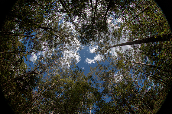
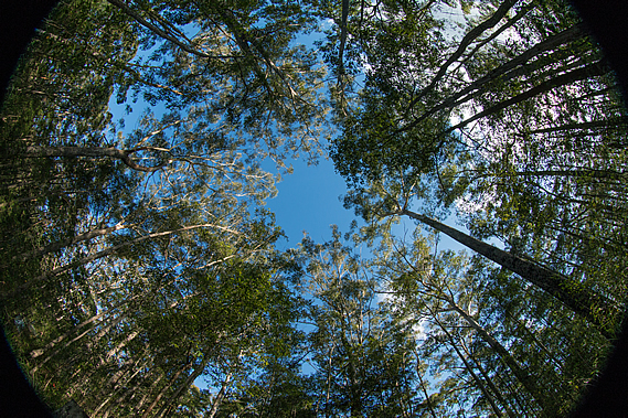
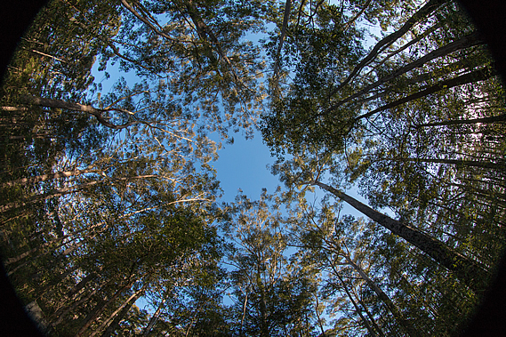
To pass the time I put my fisheye lens on the camera and pointed it straight up to experiment with getting the radial effect of the tall trees in the campsite rising to a vanishing point in the centre of the frame. Here the trees rose almost vertically overhead seeming to point towards the infinity of the blue sky overhead. Large white clouds drifted by from the south east giving the illusion the forest was moving, but it was the air overhead blowing over the range even though I couldn’t feel any wind at all in the shelter of the forest. The others thought perhaps I had seen a bird or snake up in the tree and initially came over to find what I was looking at. Then they realised I was just being crazy doing some random ultra wide angle photography. I think you have to be a photographer to appreciate some of the things I get up to in order to get the interesting shots. I’m always after interesting shots. Although it is quite tranquil being in the middle of a eucalyptus forest, the scrubbiness of the vegetation and the harsh contrasts between sunlight and shadow don’t actually make very interesting pictures. It is in places like this where you need to get really creative to get shots that are worth showing.
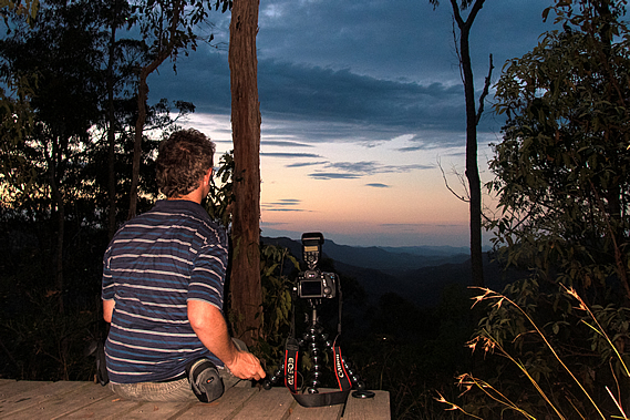
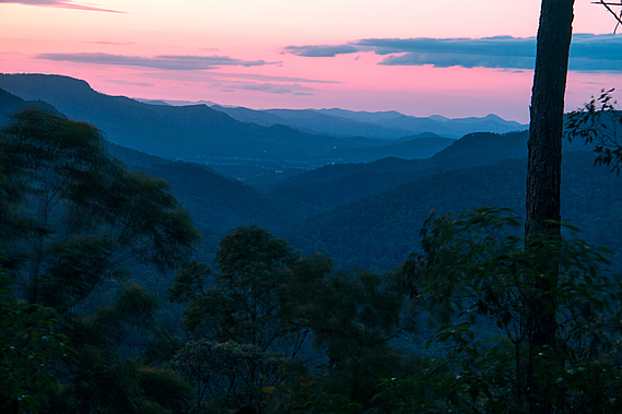
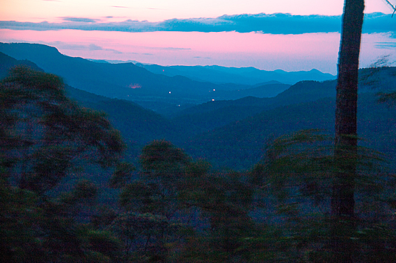
When I was done with vertical wide angle shots, I went to the other extreme with taking macro shots of any insects I could find. Apart from one small spider which didn’t want to pose, the insects were all hidden, no doubt sheltering under the thick scrub with the snakes, or perhaps high in the forest canopy with the elusive koalas. A pair of kookaburra did briefly land in the trees above me, laughing raucously as if to mock me for having the wrong lens – actually I didn’t even bring the telephoto lens with me. That’s far too big to hike with. The sunshine didn’t last too long. As the summer sun started to make a beeline towards the north western horizon, cloud completely covered the sky. With tents up and dinner finished, I headed out to the lookout to watch the sun set over the Gheerulla Valley. The young couple were already there, but it was obvious there wasn’t going to be much of a sunset tonight. The cloud cover was too thick. The couple quickly gave up on looking at a sunset, so I set up the camera to do some long exposure shots to be able to make the most of the dim colours of the overcast sky. Unfortunately it was a little windy up here, so the foreground foliage was going to be moving in the shots.
It was completely dark when I returned to the campsite. The moon was obscured behind the thickening cloud low cloud drifting in from the south east, so we decided to head off to bed for the night. The humid air was still devoid of the sound of last night’s rain drumming on the tent. In fact it was dead silent. I couldn’t hear the other guys, nor could I hear the couple who had pitched their tents over on the other side of the campsite. Even the wild animals that should be roaming around here were very quiet. Exhausted from the lack of sleep last night, I lay on top of my sleeping bag and fell asleep almost instantly. |
||||||||||||||||||||||||||||||||||||||||||||||||||||
|
||||||||||||||||||||||||||||||||||||||||||||||||||||