Introduction to today's journey
You climb to reach the summit, but once there, discover that all roads lead down.
- Stanislaw Lem
MOST of the significant landmarks along the Heaphy Track were named after significant historical figures, mainly explorers to this remote terrain. Mount Perry and Perry Saddle is a notable exception. Lost to ime si the source of the name of the mountain, the saddle and the hut all called Perry, and all some of the most recognisable features on the track. There is a scant record of a Perry and Day who were contractors for the Aorere Works Committee of the Collingwood County Council. They were contracted to cut two miles of track of a grade for horse traffic along what is now the current track rising from teh Arorer Valley towards the saddle in 1887 in the early stages of the construction of the track. Assuming this was the Perry who the hut, the saddle, and the mountain were all named after, there must have been something about him that earned these places named after him. Perhaps he did something significant that has now been lost to history. Perhaps he had been bold enough upon realising the saddle and mountain were unnamed, he would cheekily name them after himself, and he was fortunate enough for the name to catch on, to be immortalised into modern history.
Today's trek rises from Gouland Downs Hut crossing the front of the mountains passing Boot Post Corner before heading into the Perry Valley. The track continues rising to Perry Saddle where the new hut was located. As this was a short hike, I set up at the hut before climbing to the summit of Mount Perry before returning to the hut for the night.
Today's Journey
Distance trekked today: 9.5 kilometres.
Total distance trekked to date: 66.9 kilometres.
 |
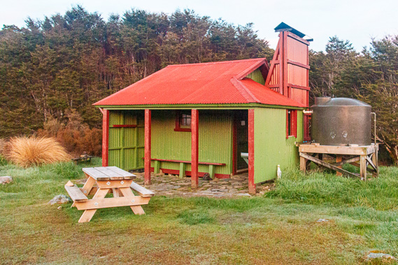
05:49 - I wake up very cold despite my sleeping bag being rated at zero degrees. It is just coming on first light outside. The old Gouland Downs hut isn’t insulated like James Mackay so the temperature inside is no doubt only slightly warmer than outside. The fire died down hours ago so the huge fireplace no longer contributes to any warmth. |
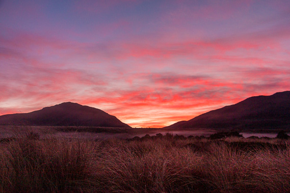 |
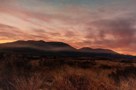
05:54 - The other three hikers who have stayed here overnight are still sound asleep so I quietly head out to the little verandah to watch the sunrise. The still air feels very cold, even colder than at first light yesterday at James Mackay. Looking out from the verandah I see the first hint of light peering through Perry Saddle. The mountains ahead of me remain dark and ominous as the clouds above them illuminate a deep pastel red colour as I eat breakfast. For over a minute the sky shines brilliant red before the more subdued colours of day begin to settle in. |
 |
05:58 - It is now light enough for me to see quite a frost has fallen overnight on the ground and on the corrugated iron roof of the hut. The temperature here is around minus three or four degrees, hardly what I expect for late spring even here in New Zealand. |
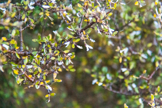 |
06:33 - Looking closely at the nearby shrubs, I see tiny ice formations at the end of the leaves where they had been breathing during the night and the moisture has condensed into tiny snow-like ice flakes. Some of these formations are nearly a centimetre long – even longer than the ones I saw yesterday morning. The cold sun finally rises perfectly positioned through the gap of the Perry Saddle. Hans has just gotten up and is heating up a billy of water for his breakfast. He filled it up last night no doubt being familiar with the cold where he comes from in Germany. The ladies are still asleep and will no doubt be for some time to come.
|
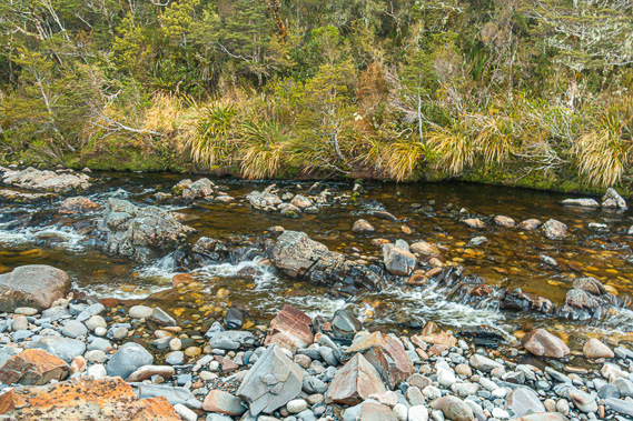 |
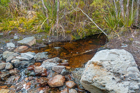
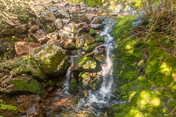
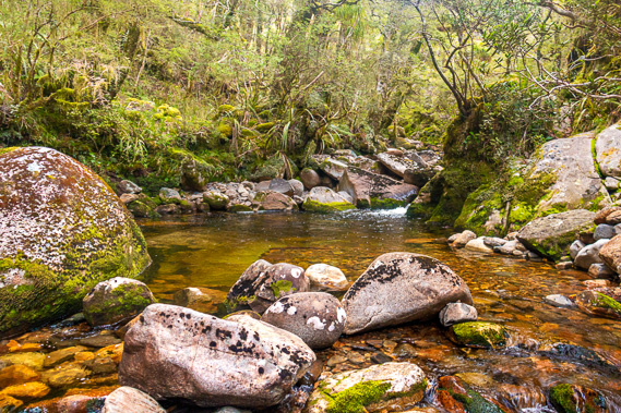
06:55 - Now the sun is up and breakfast finished, I put on my pack and start hiking the journey eastward towards the saddle. The track initially descends from the hut over thick limestone gravel through short mountain beech forest into the deeply cut gorge of Cave Creek. Cave Creek runs from the slopes of the Gouland Range to thread its way through the limestone formations around the Enchanted Forest into Gouland Downs to drain into the Big River system. Within a couple of minutes I see the cold black waters of Cave Brook cascading between the assortment of pale grey limestone and pink granite boulders washed down from the mountain.
|
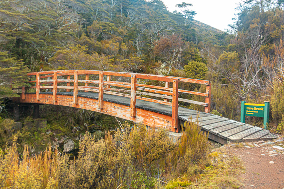 |
06:56 - Ahead is the wooden bridge crossing the stream. Its slightly arched formation looks very weathered. The bridge is stable though. Looking upstream from the bridge, the black water is almost mirror smooth. Downstream the water cascades along the rapid. It is hard to believe the two views are of the same stream. Jagged limestone formations form the towering banks of the stream under the forest of miniature beech trees. |
 |
07:06 - Once across the other side of Cave Stream, the track continues heading upstream, quickly climbing a moderate gradient above the gully to the plateau shelf of the Gouland Downs. Once out of the gorge I look back across the Enchanted Forest to Slate Range and the narrow gap through which Big River drains through. The low forested hills in front of the range has smudges of cloud hanging in front of them, remnant of last night’s chill. They are quickly lifting, perhaps from the subtle updrafts of the sublimation of the frost of the night. |
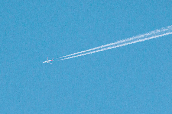 |
07:07 - A plane passes overhead having left Wellington now heading across the Tasman. These vapour trails are a part of most mornings here with the daily run to Australia. The travellers on the plane will have spectacular views of the almost perfectly clear South Island today.
|
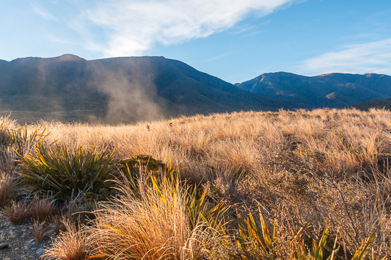 |
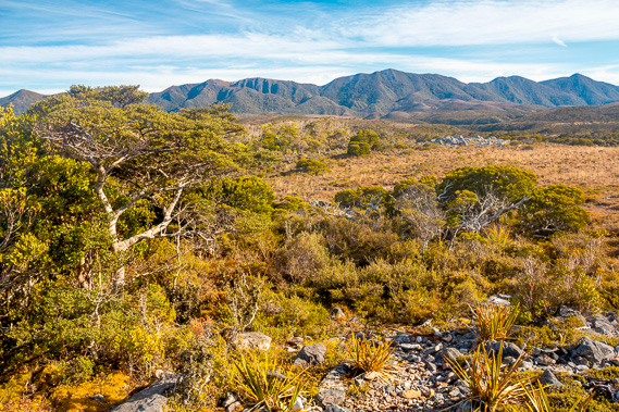
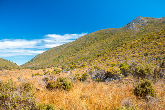
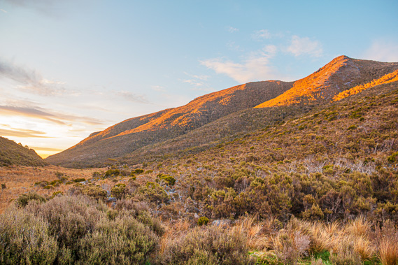
07:14 - Once I reach the top of the gorge, the sun shines brightly into my eyes. The tussock here is covered in frost which I see right across the face of the downs, looking like a very light dusting of snow. The sun brightly illuminates the icy tussock ahead of me creating plumes of steam rising from them. It is quite a long walk along the ridge of the plateau, sloping up towards the hills now towering above. This part of the track roughly follows the old Government Track James Mackay and Arthur Knyvette cut in 1862, before it was abandoned requiring the construction of the new track which more closely follows the old Maori trail in the early 1890s. |
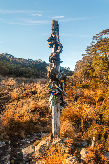 |
07:52 - Finally the track reaches a corner, with a large squared pole of solid timber, split and greyed with age. The pole has about 25 pairs of shoes hanging off it. Most of these are boots, but there are some sandals and flip flops as well. |
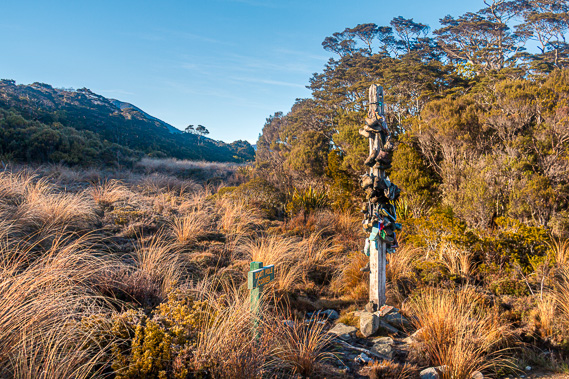 |
07:53 - This is Boot Pole Corner, the place where people hang their old boots. You’d normally see a place like this at the end of a track, but not here in the middle where obviously hikers would have had to carry their old boots all the way out to here in between two huts after a day and a half of hiking over the Brown Saddle on the other side, or several days hiking from Kohaihai. That is a lot of extra weight to be carrying just to put them on this pole. With all my camera gear carrying an old pair of boots isn't an option for me. Of the thousands of people who have hiked the trail in recent years, twenty five of them managed to discard their boots here. I’m sure they were all locals, or perhaps some others with local knowledge of the post. All of them had lugged an old pair of boots along the trail just to retire them on the pole.
|
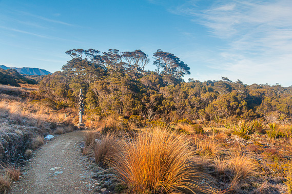 |
07:54 - Perhaps some of these boots did wear out on the trail, forcing the hikers to revert to a pair of running shoes. Boot Pole Corner is at the edge of a mountain beech forest, stunted by the poor soil and high altitude of the downs. The forest runs down the edge of a steep gully clear enough to have a good view across to the hills on the other side of the downs. The sun climbs above the low ridge above providing clear illumination of the post above the frosty ground.
|
 |
07:59 - From Boot Pole Corner, the track rises above the terraces of the Gouland Downs northwards towards the entrance to Perry Saddle. There is now a clear view across to where the upward sloping downs suddenly end, and of the Saxon range now looking like another plateau set a couple of hundred metres higher than the plateau I have crossed. It is not long before I am high enough to see across the Enchanted Forest and the tiny Gouland Downs Hut sunning itself at its edge. In front of the hut runs the deep scar of Cave Stream cut across the plateau deep in the limestone rock.
|
 |
08:01 - The steam has stopped rising from the tussock, so I guess all the frost would be cleared from around the hut. I can just see in the distance the two young ladies who are staying there are up and getting ready to leave to head across to James Mackay. I guess Hans has already left and would have passed through the Enchanted Forest now crossing the tussock plain of Gouland Downs towards Saxon. Behind the Saxon Range I see the start of the Wakamarama Range, the northernmost mountain range of the South Island extending almost all the way up towards Cape Farewell. The mountains are in the way here, but with a bit of luck I will be able to see up to the cape either later today or tomorrow morning.
|
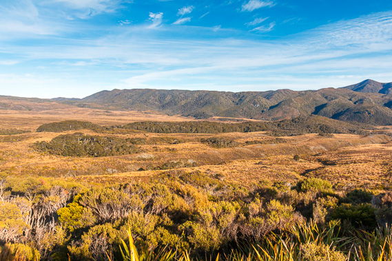 |
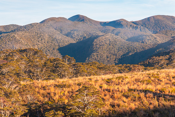
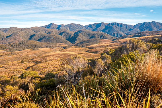
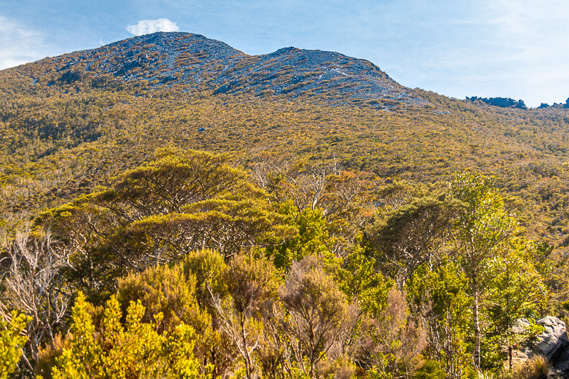
08:02 - To the south I can see along the Gouland Range all the way to Mount Gouland, appearing blue in the distance. The edge of the plateau is still at an elevation higher than I am, so there are no views back to the sea yet. The track reaches the top of the fan plateau and the steep terrain becomes gently sloping grassland heading up to the mountain. This is another terrace in the plateau, the last one against the side of the mountains. The track heads in a straight line almost directly towards the mountain before entering scrub and crossing the headwater stream of Sheep Creek.
|
 |
08:16 - Sheep Creek was named because attempts had been made at running sheep up here on the downs. Although the tussock looks healthy from up here, the climate on this plain was too extreme for livestock to live. Gouland had looked over the land and didn’t even try bringing any sheep up here. Over the following decades there were several unsuccessful attempts at running sheep up here on the downs, but the climate was too tough for them. The stream enters a dark ochre small pool before passing some large white granite boulders and crossing over the track over large stones. It is an easy crossing through.
|
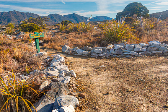 |
08:23 - From Sheep Creek the track gradually ascends the side of the mountain above the plateau towards the entrance valley to Perry Saddle. It is not long before I reach the spur at the entrance of the valley. A side track lined with granite boulders on either side leads out towards the end of the spur towards a weathered picnic table. A sign at the entrance indicates this is Picnic Table Corner. With making great time and already being over half way to Perry Saddle, I decide to stop here for a while. By now the sun is climbing above the triangular peak of Mount Perry, though it is projecting very little warmth though the thin mountain air.
|
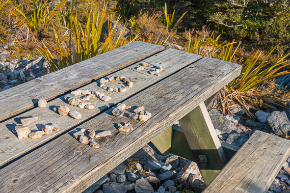 |
08:24 - I reached the picnic table. The top has a message written with stones. It says something like “Caio W. RP.” Clearly this is a message from someone (RP) to someone else (W) doing the track a day behind perhaps. Or maybe it is a message from one group to another heading in opposite directions. This sign may have been here for days. There is no way of telling whether it had served its purpose in delivering the message. Perhaps the message was been delivered weeks ago, but the hikers who have come here ever since have not disturbed it thinking it hasn't been delivered. From the picnic table there is a clear view almost all around. There are a few very stunted beech trees and some small shrubs growing in what would often be a very harsh environment, but today it is clear without a breath of wind. Retreating under the shelter of the shrubs are large patches of sphagnum moss.
|
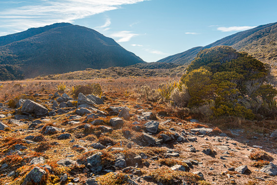 |
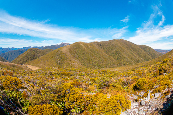
08:26 - Behind me the saddle still seems to be quite distant. It has until now seemed quite low and close from the Gouland Downs Hut even though there is over two hundred metres difference in elevation between them. The summit of Mount Perry stands another four hundred metres higher, now towering over the saddle. Looking to the north I now see along most of the length of the Wakamarama Range stretching northwards towards the cape. There seems to be a saddle at the end of the plains that is about the same elevation as where I stand, perhaps a hundred metres lower than Perry Saddle.
|
 |
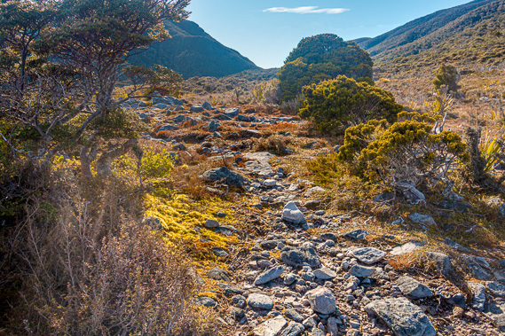
08:27 - Behind me the slope gradually steepens as it rises up the side of the unnamed mountain. Small grassed terraces are broken by enormous boulders that had rolled down the mountain during past earthquakes. A thin layer of icy high cloud covers the sun reducing the extremity of the contrasts. By now the sun is directly over the top of Mount Perry, leaving the steep slopes of the mountain under shadow.
|
 |
08:45 - I set off from the weathered picnic table with the message in stone still intact, thinking perhaps like many before me, its recipient hasn’t come through yet. I return to the track and continue following it in a gradual uphill into the valley leading up towards today’s destination at Perry Saddle. Very quickly the vegetation changes from subalpine tussock and scattered scrub to beech forest as I enter the valley into Perry Saddle. The long slender trunks of these old trees tower upwards to capture the light above the canopy. These are the lucky trees. Many trees germinate to struggle in the darkness of the subcanopy waiting for decades, sometimes centuries, for an old tree to fall down so it can rise and take its place. |
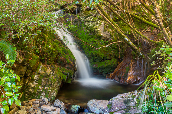 |
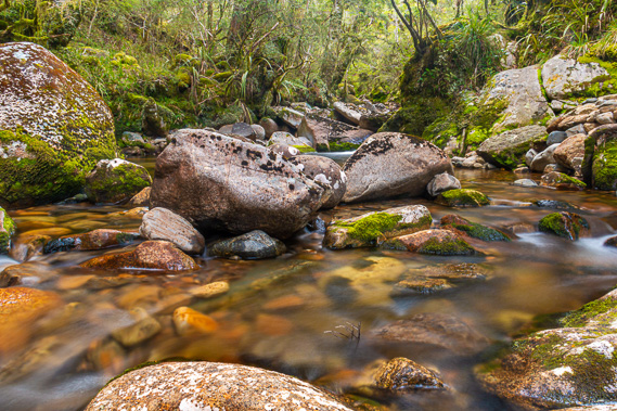
09:26 - The forest is rather dark, blocking off most of the bright sunlight filtering through. The slope plunges steeply to the bottom of the narrow valley only to rise in equal steepness up the other side. The track continues its gradual ascent towards the saddle hidden deep in the forest. Ahead I hear the bubbling sound of a cascading stream. Through the darkness of the forest I see a bridge crossing the stream. A small waterfall drops just before the bridge. This is the first sound I have heard since Cave Creek. I briefly stop at the creek to take a few long exposure shots. This has been the first opportunity for me to do long exposures over this entire trek. There had been some potential opportunities along the coast, but the heavy rain and limited time before darkness made doing long exposures impossible. Exposing the lens for any length of time in wet easther results in the lens getting covered in raindrops severely distorting the image.
|
 |
09:31 - Here I have the opposite extreme, with the enormous contrasts between the brilliant patches of sunlight making its way through the canopy, and the very dark shadows of the trees. Fortunately there are no raindrops around to distort the image, but I have the huge lighting contrasts to deal with. Ideally waterfalls should be photographed in overcast conditions. Following the short stop at the creek the track heads around a short spur with a small break in the forest from where I see down the valley. The downs are hidden from view by the forest but the hills of Slate Range are still visible.
|
 |
09:56 - Around the next gully flows another stream, with boulders strewn over quite a wide area from a landslide brought down by a past flood. Fawn Stream cascades down in two separate channels around these rocks. The bridge sits just above the strewn rocks to provide another dry crossing. The next spur has a view across the front of Mount Perry. The mountain suddenly appears enormous now that it is so close. Into the next gully the track suddenly descends to another small bridge crossing the cascading Ainslie Creek. The track has divided into two as it had done in the previous streams. The main track fords across the stream and a bridge cut across the gully above the stream is there for when the water level was running high, or for people like me who want to keep their boots dry after being soaking wet for the first two days.
|
 |
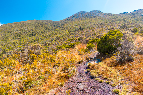
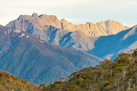
10:07 - From Ainslie Creek the track begins to steepen a little until it clears the thick forest to reveal good views of the valley. From here I see the towering face of Mount Perry. Scrub covers the slope for much of the way up but towards the top it is very rocky. The grey rock see on its upper slopes would be covered in snow for much of the winter. Looking ahead the top of the saddle is still some distance away. I can’t see the hut though, so it must still be hidden away somewhere up there. The track continues through thick heathland scrub a little too high to get any views through.
|
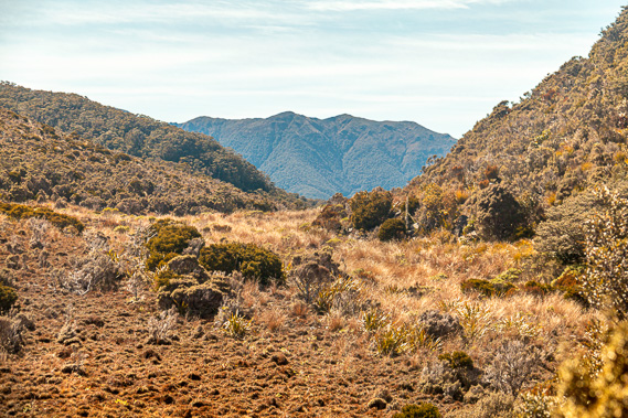 |
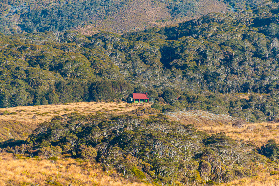
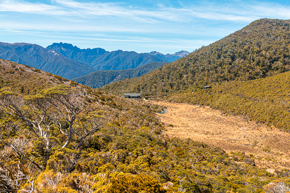
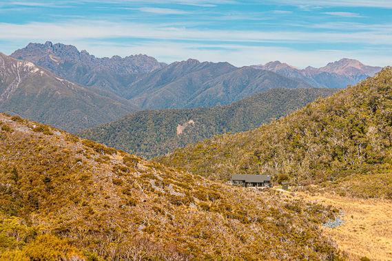
10:10 - The track follows gully after gully heading up towards the saddle. The scrub thins and the valley floor widens from a narrow forested gorge to scrub, before it clears completely into a wide tussock swamp similar to the ones at Mackay Downs yesterday morning. A range of mountains is now clearly visible beyond the saddle, but there is still no sign of the hut. The track follows a few metres above the tussock as the valley starts levelling off and the gorge below disappears. The rocky track enters the thick scrub again but shortly afterwards I see the dark shape of the rangers’ hut. Upon almost reaching the ranger’s hut the track turns to the left onto the saddle. The new hut is standing almost right on the saddle.
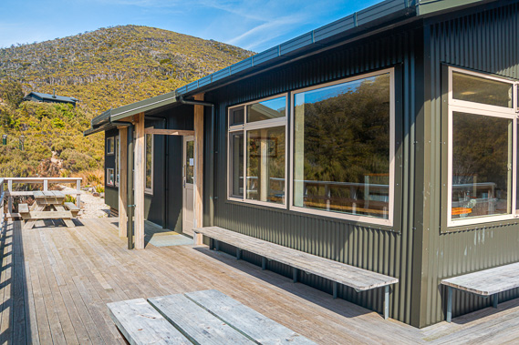
It is a welcome relief to reach the hut even though this was a short walk climbing to the saddle. A sign at the main entrance says “Perry Saddle Hut, 860m”. This is the highest hut on the Heaphy, but not quite the highest point on the track. The highest point of the track is about another half hour away where the track has risen a further 55 metres in elevation before its long descent down to Brown Hut.
|
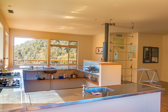 |
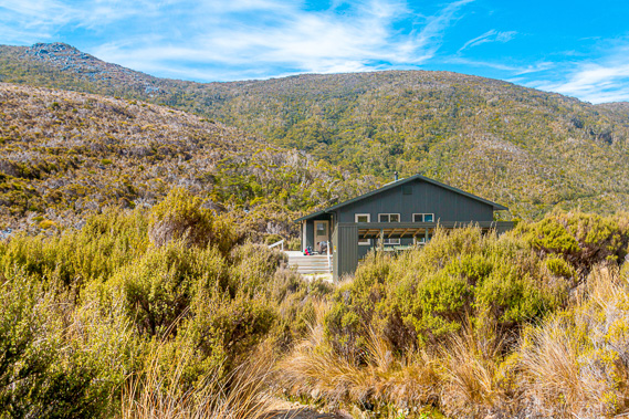
10:29 - There is nobody else inside the hut. I did not pass anyone on the track this morning. I had asked the guys at Gouland Downs if they had passed anyone heading in my direction yesterday whilst hiking up from Brown Hut. They hadn’t. This hut was completely unoccupied last night, sitting lonely high atop the saddle. The three people who had come up the mountain from Brown yesterday had all gone onto Gouland Downs where I had stayed. The design of this hut is similar to James Mackay and Heaphy. There is a mud room where I take off my boots and leave my pole. The mud room leads into the large open plan kitchen and dining area. Huge double glazed windows along the walls provide awesome views out across the saddle in both directions and a spectacular view of the nearby Mount Perry. Looking back in the direction I have come the view just covers the gradually sloping tussock valley ending just before the gorge dropped into the Gouland Downs. Looking out the other direction the view is even more spectacular with the saddle quickly dropping into beech forest down to Gorge Creek which swings around the valley before tumbling hundreds of metres into the Aorere Valley. The cooking area is set up as a bay in the middle of the kitchen/dining room. Behind this in the middle of the room is a small log fireplace similar to the one at James Mackay. On either side of the kitchen are large rustic wooden tables, room enough to fit quite a lot of people when the hut gets busy.
|
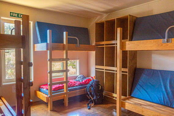 |
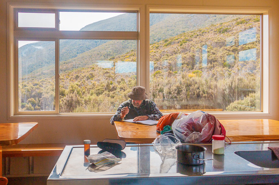
10:32 - A notice board has a welcome message from “Ranger Steve”. I have not seen any rangers on the track so far even though the three main huts had adjacent ranger huts. In the top right corner of the noticeboard is a small photo of Heaphy’s gravestone in the Toowong Cemetery in Brisbane, where I had visited several months ago. At the southern side of the hut is a small hallway leading to three bunkrooms. Unlike the other huts these rooms have names - Dragon’s Teeth, Kaka Saddle and Mount Perry. Dragon’s Teeth is the name of the jagged peaks seen from here across the Aorere Valley. These peaks form part of the Douglas Range. Kaka Saddle is the next pass across the Gouland Range to the south. This pass is higher than Perry Saddle at 1007 metres above sea level. It is named after the large green forest parrot that was once common here. Mount Perry is the mountain that rises directly above the saddle, which at this point I am considering climbing having arrived here so early. Being the first in the hut I set myself up in one of the lower bunks beside a window in the Kaka Saddle room and have a morning tea snack resting in the dining area overlooking Mount Perry. It is still mid morning so there is plenty of time to explore the area on what has turned out to be another gloriously fine day.
|
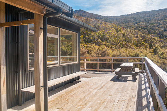 |
10:33 - I head outside on the huge deck overlooking the mountainous Aorere Valley, with the river hidden some six hundred metres below and Dragon’s Teeth towering ominously above them. Etched into one of the windows of the hut is the story of Reuben Waite and his nephew James Waller who hiked the track in 1871 in the same direction I am hiking. The story recounts how they carried 25 kilogramme packs in wet weather, having to cross the swollen Heaphy River 14 times, and getting lost in the thick bush ascending towards the downs. Upon reaching the downs they battled for four days against hail, snow, rain and a blistering wind. Finally they reached ‘the saddle’ at this location, and crossed over into the relative shelter and warmer temperatures of the Aorere Valley. The story concluded with stating that the Maori usually travelled around the coast by waka (canoe) rather than hiking over the trail. In those days that seemed to be the most sensible option even though the sea around the top of the South Island was treacherous. Every other hut on the track I have passed so far was named after someone who had been well known who had significantly contributed to the history of the track. The Perry Saddle hut is a notable exception. Lost to time is the source of the name of the mountain, the saddle and the hut all called Perry.
|
 |
10:34 - There is a scant record of a Perry and Day who were contractors for the Aorere Works Committee of the Collingwood County Council. They were contracted to cut two miles of track of a grade for horse traffic along what is now the current track from the Aorere Valley into the Perry Saddle back in 1887 in the early days of the construction of the track. Assuming this is the Perry who the hut, the saddle and the mountain were named after, there must have been something about him that earned him these places named after him. Perhaps he did something significant that has been lost to history. Perhaps he had been bold enough upon realising the saddle and mountain were unnamed, that he would name them after himself, and he was fortunate enough for the name to catch on, to be immortalised into modern history.
|
 |
10:35 - It is interesting to note the mountain on the other side of the saddle has remained unnamed to this day. Perhaps some of the earlier explorers had given it a name, but those names never caught on like Perry. Perhaps this mountain had been named Mount Day by the pair as they constructed the horse trail to the saddle. Such details are very much lost to time. The original hut had been built between here and the ranger hut in 1972. I had stayed in it last time I came through here in early 1996. Construction of the new hut began in February 2012 and completed at the end of May that year. The project required 55 tonnes of equipment and building materials to be lifted up the mountain from the Aorere Valley. Once the new hut was completed, the old hut was demolished and removed in June. It was a challenging build at such high altitude. Although work started in the heat of summer going into early autumn, there were numerous days of rain with strong buffeting winds, and even a sprinkling of snow. Fortunately most of April was calm and sunny. In the contractors’ words, the fine weather helped them to “knock the old bastard off” ahead of time. Speaking of fine weather, the conditions outside look perfect. The sky is clear aside from a few horsetails of Cirrus cloud sweeping across the entire sky. It is time to explore the area.
|
 |
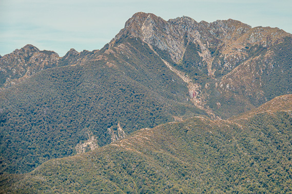
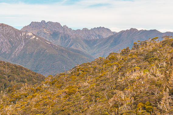
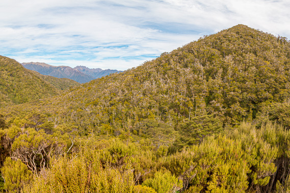
11:02 - Mount Perry hovers high over the hut behind the northern side of the saddle. The scrub clambers up its steep side gradually merging with the grey rock of its steep upper slopes. I had climbed Mount Perry last time I was on the track heading from Brown Hut westward towards Kohaihai in 1996. I recall the climb being relatively easy, but twenty years ago I was a lot fitter. That being said there is a sign warning that the route up the mountain is for experienced hikers only. Well I have been up there before easily reaching the summit, plus the weather is favourable with not a breath of wind outside, nor any signs of the weather changing until at least tonight. I decide to make an attempt for the summit.
|
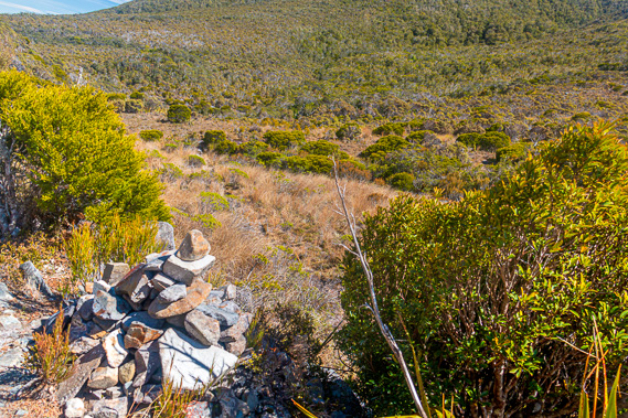 |
11:09 - I follow the track back to an uneven cairn of slate rocks I had seen about four hundred metres from the hut. From the cairn I see a rough mostly overgrown track heading across the tussock and entering the scrub on the other side. The track disappears until re-emerging at the steep rocky section where it zig-zags in a series of switchbacks up the mountain. It is a bit of a scramble down the bank to the rough track through the tussock. It remains unbroken until reaching a small creek cut into the bottom of the valley. A quick step gets me over the creek and almost immediately begins rising against the side of the hill.
|
 |
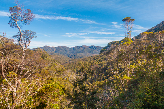
11:13 - The route follows loose stones heading towards the scrub above me, quickly rising above the tussock flat. It enters the thin scrub of mostly Dracophyllum traversii and the occasional beech tree. Little orange plastic triangles nailed to some of the trees lead the way on this otherwise difficult to navigate track. I continue climbing through the scrubby bush for some time before reaching a small clearing from where I see the huts below, already looking rather small against the backdrop of the Devils Teeth mountains on the other side of the Aorere River. Looking the other way down the valley I just see the top of the other side off the downs, and the blue band of the Tasman Sea beyond rising to the paler blue sky partially covered in high cirrus cloud all the way to the horizon. |
 |
11:18 - Looking ahead the mountain is becoming increasingly steep with the route heading up what seems to be the steepest way possible. There is another patch of bush to get through before the route climbs across the steep bluff ahead. Beyond the bluff is another rock face skewed off to the right. From here it is hard to tell if this is going to be the summit. |
 |
11:19 - Although the top of the mountain is only about four hundred metres above the hut, it seems to be a lot higher than that from here. I continue climbing the loose slate rocks cleared of vegetation from many hundreds of people who have climbed the peak in the past – I was one of them twenty years ago. The route once more enters the scrubby bush, with the trees very stunted and spaced apart with large boulders between them. To my surprise moss is growing on the ground and on the trunks of the trees. The track suddenly splits into two, both routes looking equally accessible and neither having any marker tags. I follow the route to the right which after a few metres becomes extremely rough. I have gone off the track but am able to traverse back across the rock to the correct route again.
|
 |
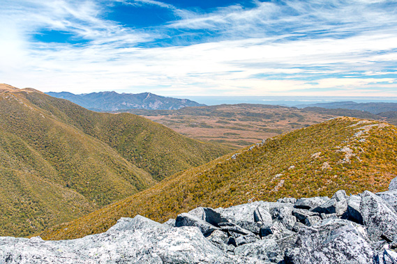
11:38 - The trees become extremely stunted and windswept at this point as they thin out at the bottom of the large rock slide under the bluff I am about to ascend. The slope has been fairly gentle for a while but is now quickly steepening as it approaches the bluff. Now I am out of the trees I have a clear view all around. The hut is just a large speck on the saddle. The altitude I have gained has provided a clear view over much of the rugged Tasman Mountains. The unnamed mountain on the south side of the saddle marking the start of the Gouland Range is still blocking much of the view across the valley, but I can now see more of the distant sea.
|
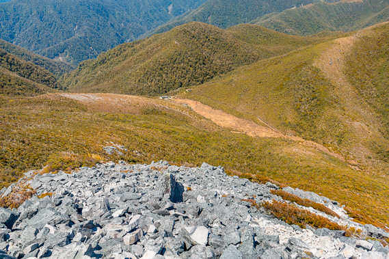 |
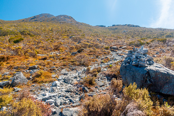
12:09 - The scrub quickly thins until the track is zig-zagging across large slate rocks. The stones on the track are small enough to easily walk on, but on either side they are rather large boulders that would be difficult to climb. The bluff becomes steeper and steeper until the mountain feels it is almost going to fall over onto me. The route is clearly marked with a series of rock cairns marking the way. Near the steepest part of the bluff I reach an ancient beech tree bent almost right onto the ground and trimmed almost like a bonsai tree being terribly windswept in these highly exposed conditions on its lonesome. Fortunately there is only a very gentle breeze, but during stormy conditions the bluff could experience very strong winds.
|
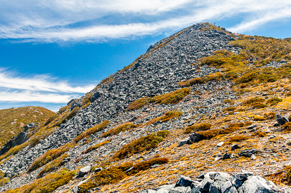 |
12:17 - Once on top of the bluff the slope lessens considerably with thin grass covering the stones making it much easier to walk on for a while. Ahead of me is the second bluff, but fortunately the worn route goes to the left of it into the low scrub. This is an easier climb through the scrub up the side of the second bluff. As the slope begins to ease off I see the communications tower at the top. I am almost there. When I last climbed Mount Perry twenty years ago, there was no communications tower. It has been built there since my last climb. Although the final section to the summit is a slight to moderate grade, it requires clambering over large boulders.
|
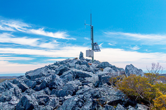 |
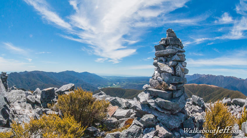
12:32 - The tower is a single mast with a box and a small solar panel. A couple of small aerials are mounted to the top. A few metres past the communications tower stands a two metre high cairn marking the summit. Well I presume it is the summit as the ridge beyond the tower is quite long and flat. There are a few other smaller cairns erected further along the rocky ridge. I clamber over the rocks to the communications tower.
|
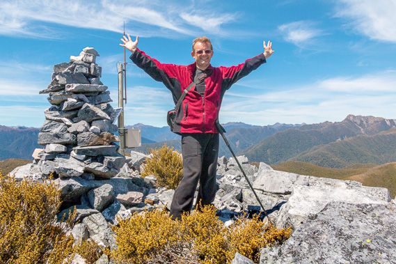 |
12:43 - From the little tower I easily reach the cairn where I touch the rather loose stones on top of it before finding a spot just below it to rest. The area is completely free of litter apart from a small camera pouch accidentally dropped probably some time ago. To my surprise there are a couple of small scrubby shrubs growing in between the large rocks, somehow surviving the harsh mountaintop climate. I am now high enough to be in the realm of the kea – the glorious mountain parrot only found on the mountains of the South Island. There aren’t any up here today.
|
 |
12:46 - From the lookout at the summit I see northward beyond the mountain. From here I see along the peaks of the Wakamarama Range out to Golden Bay. To their right are the green pastures of the Aorere Valley with the river meandering across it in a silver ribbon. Just inshore from the bay is a large lagoon starting at Collingwood and extending almost to the range. The lagoon marks the mouth of the Aorere River. Some distance offshore lies the long sandbanks of Farewell Spit, the world’s longest sand spit. It contains sand carried up by the turbulent waters of the West Coast from a strong Antarctic current. The sand deposits here at the top of the South Island give the top of the South Island its distinct kiwi beak shape. I did a tour along the spit back at the end of 1995 shortly before my first successful completion of this trek.
|
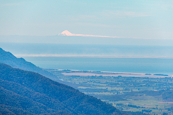 |
12:47 - Further offshore the horizon fades out with the ocean haze. Above the fine haze stands the white snow capped triangular peak of Mount Taranaki, a spectacular dormant volcano towering two and a half kilometres above sea level, almost exactly double the height of this mountain. I have climbed Mount Taranaki twice and both times reached the summit. Now I have climbed Mount Peel twice and both times I have been lucky enough to see Mount Taranaki from its summit. A stream of cloud extends from the eastern side of Mount Taranaki. Further to the east it is too hazy to see Mount Ruapehu or any of the other mountains of the North Island. |
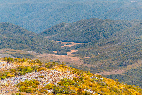 |
12:49 - To the west I see across Gouland Downs. The hut is hidden behind one of the ridges of the mountain, that means I have not been able to see the true summit of this mountain from the hut early this morning. I can just see Saxon Hut though, a tiny red dot in the distance on the far side of Gouland Downs. The two ladies at Gouland Downs Hut will have probably stayed here for an early lunch but would by now be well on their way to James Mackay. I guess Hans will be pretty close to James Mackay, going through the last of the Bonsai Forest along the upper reaches of Deception Creek. |
 |
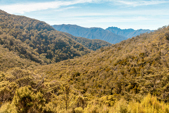
12:54 - Behind the Saxon Hut I can make out Teddy Range and the hills of Mackay Downs and further behind the Iwituaroa Range sloping down towards the mouth of the Heaphy River. The Gouland Downs conceals the coast, but I see a bank of low cloud covering the Tasman Sea. It would be overcast along the coastal route today. Looking further to the left I see the mountainous Bellbird Ridge rising from the coastal part of the track up to Mount Gouland. From there the country becomes very mountainous with the jagged tops of the Tasman Mountains around to the deeply cut Aorere Valley. All the mountains seem to be roughly the same height indicating they are part of a huge block of land that has lifted over a kilometre above the sea as the South Island was forming. When the fault lines split the Zealandia continent in half, Fiordland had been joined to these mountains.
|
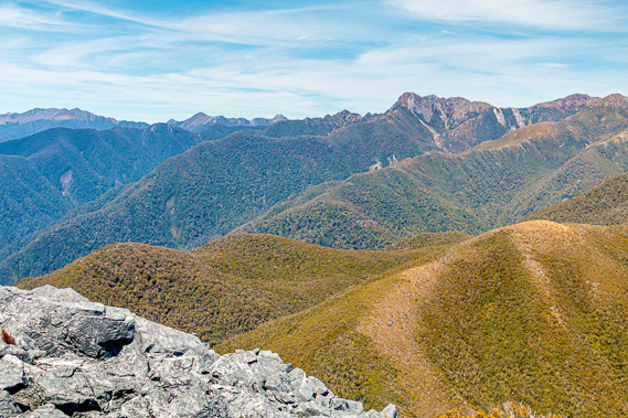 |
12:40 - The mountains gradually dissipate towards the coast. Directly below me to the east was the lower peak of Mount Brown, named no doubt after the tussock on it's nearly bald top. Tomorrow the track winds its way around the other side of Mount Brown descending to the Brown River and out to Brown Hut at the end of the track. Huge horsetails of cirrus cloud hover overhead, indicating stormy weather will be on its way in a day or two. I am fortunate to be on top of the mountain today because there may not be any views tomorrow when I reach the trackside view points.
|
 |
12:45 - The cloud overhead is thickening, so I decide to start heading down the mountain. I clamber over the rubble along the top ridge back to where the rough track drops down the side of the bluff. Looking out to the next ridge it doesn’t seem as steep as this one, but the top of the spur has a long row of rocks sticking straight out of the scrub. Once I reach the top of the lower bluff I ease myself down the zig-zagging route. There are spectacular views of the valley leading to the saddle, with the deep cut of Gorge Creek having eroded its way into the valley creating the saddle.
|
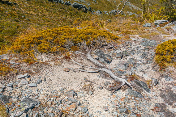 |
13:17 - Part way down I pass a tree lying down on the ground following the direction of the prevailing wind. It is completely calm here today but the flatness of the tree indicates it was a most harsh environment to survive in. As I continue down the side of the mountain it becomes less steep towards the small hump where the scrub starts. It is a rather long descent and I am relieved to reach the scrub. At least here the slope is less and I have trees to hang onto.
|
 |
14:20 - At the end of the bluff the terrain steepens a bit, but at least I have the trees to hang onto. Thankfully here in New Zealand there are no snakes or spiders to watch out for. Eventually I reach the open tussock of the valley. Once across the tiny stream I return to the track and head for the hut. I have successfully conquered the mountain.
|
 |
14:43 - Nobody was here at Perry Saddle Hut when I arrived from Gouland Downs this morning. Upon my return from climbing Mount Perry, there are several people who have arrived over my three hours of absence. In the corner around one of the big dining tables overlooking the spectacular Aorere Valley sits a young German group. They have arrived about half an hour earlier having trekked from Brown Hut this morning. Now they have settled in, they are cooking either a late lunch or perhaps a very early dinner. They are obviously well seasoned travellers, or at least seem to be with being very well equipped with the latest gear and talking about one young lady they have overtaken who was carrying a rather heavy pack having packed an entire set of clothes for every day on the track. The group from Germany are taking pride in travelling light.
|
 |
15:51 - Seated at the large table on the other side of the room is an older very fit looking guy in his late 50s to early 60s. He has a neatly trimmed beard and a floppy hat that covers much of his face. He has a small pack next to him and he is eating a very fresh looking salad sandwich. How I am beginning to miss the fresh food. We introduce ourselves. Derry is quite an enterprising man from Golden Bay who does car relocations from end to end of the track (he also does the Wangapeka Track crossing the Tasman Mountains further south). He picks up the client’s car at one end of the track, drives the 454 kilometres to the other end (though he is adamant it is 475 kilometres), before walking back to Golden Bay in just two days, staying at the Lewis Hut. Somewhere along the track he passes his clients and hands the car keys back to them.
|
 |
16:22 - I saw his regular entries in each of the hut books where he briefly rests. In the book at this hut, his comments are always “Down to Brown”, hinting that the final leg that I’ll be walking tomorrow drops a good seven hundred metres back into civilisation. Once there, he returns home until the next client is ready. Derry tells me he does this trip about twice a week. No wonder he looks so fit – driving over 900 kilometres and hiking 152 kilometres on a weekly basis. At least he gets paid to do it. The distance between Lewis and Brown is a good 56 kilometres. That’s a huge walk for one day. Given he left Lewis this morning, he is making extremely good time.
|
 |
16:24 - Derry mentions the four young ladies from DOC who are staying at the Lewis Hut this week. The river has over the past few days dropped enough for them to be able to get to all their sample stations. That being said though, they are rather exhausted from all the hiking through the incredibly dense forest and karst formations around the Heaphy Valley, multiple crossings over the river, and over the epically difficult Iwituaroa Range. It has been a tough week for them, but they are getting helicoptered out tomorrow back to the comfort of home in Hokitika. Derry did see my entries in all the intentions books, and in particular saw my record in the Lewis Hut book with having reached Field Cave. Apparently not many people succeed in finding the cave, so I had been very fortunate to have joined up with a group with guides who knew where they were going, even though we did get a little bit lost. That was quite some time ago now. Many miles have been trekked since then.
|
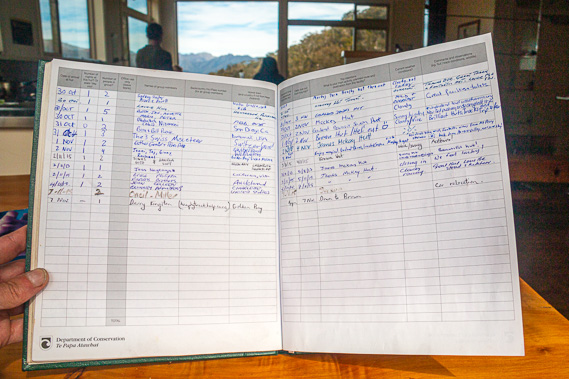 |
16:27 - Derry packs up and heads off “Down to Brown”. He has since retired from doing relocations and had a very close call falling down a remote mountain alone in the middle of the Tasman mountains in 2018, but survived OK. I continue looking through the intentions book. Most entries in the book are pretty stock standard with about 80% of travellers heading from Brown to Kohaihai. There are some very interesting entries as one usually finds in the intentions books. I have seen an entry at every hut by some disabled traveller from Thailand who wrote she is walking the length of New Zealand but not staying at the huts or campsites due to the expense. So where was she staying? In every hut these comments are followed by all sorts of rebuttals about the cost of maintaining the huts and tracks. Some hikers have commented about the fat wekas at every hut. Others mention heavy driving rain and encountering flooded sections of the track. The comments over winter are mainly from cyclists doing the track during the winter cycling season. Few people seem to walk the track over winter. The occasional hiker mentions they have the entire hut to themselves. I see one comment of this nature from a few weeks ago. The following entry in the book from someone staying the next night adds the comment underneath “Would you like a hug dear?” The atmosphere when staying in a hut alone would be very different. A large part of staying in huts involves interacting with other travellers, each on their own journey of discovery through the park. Every person in every hut has their own story to tell. When you have an entire hut to yourself, or if you are in a large group not interacting with the other groups you miss those stories.
|
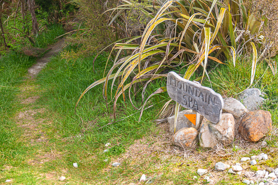 |
17:05 - The cloud overhead is thickening as the air cools. A group of four middle aged people from Nelson arrive at the hut – three brothers and a sister. They tell me is was forecast to start falling from tomorrow. The fine spell of the past two days is apparently coming to an end, though the rain won't be heavy as I had encountered on the coast. This is pretty normal for New Zealand weather. A couple of fine days are always followed by a couple of days of rain. Here on the West Coast and in the mountains the fine spells are often missed altogether with rain often falling for weeks on end. I have been very fortunate to have received a couple of sunny days to cross the downs in perfectly clear conditions and to have reached the summit of Mount Perry. Not too many people get that luxury coming through here. I walk out of the back of the hut to the campsite washing up area. This is where the original hut built in 1972 stood. A sign points to a dark track heading downhill into the forest. The weathered wooden sign says “Mountain Spa”.
|
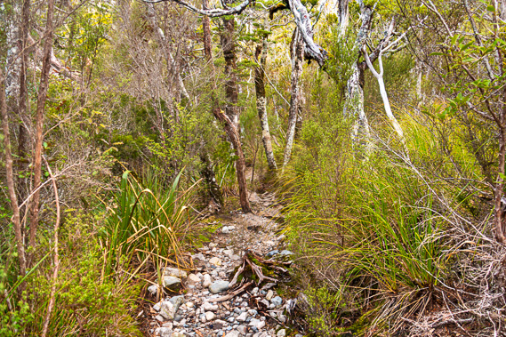 |
17:12 - I follow the very steep rough cut track straight down off the side of the saddle towards the stream. The wiry forest gradually thickens as I continue descending. The ground becomes covered in moss and ahead I can just hear the cascading stream running unseen along the bottom of the valley. |
 |
17:32 - I quickly reach the bottom of the valley. The stream runs between huge moss and lichen covered boulders on its journey towards what would be a very steep gorge dropping down into the Aorere River far below. Like all New Zealand mountain streams the water is crystal clear and very cold. |
 |
17:41 - A small rapid runs into the large pool the locals call the Mountain Spa. It is far too cold to swim in, almost heart attack material. The cold climate at this altitude combines with the thick beech tree coverage giving the sun almost no opportunity to heat the water. Only the bravest of the brave would use this spa. The water hole is mostly natural, but a few strategically placed rocks raise the level of the crystal clear water a little to provide submerged seats to sit on.
|
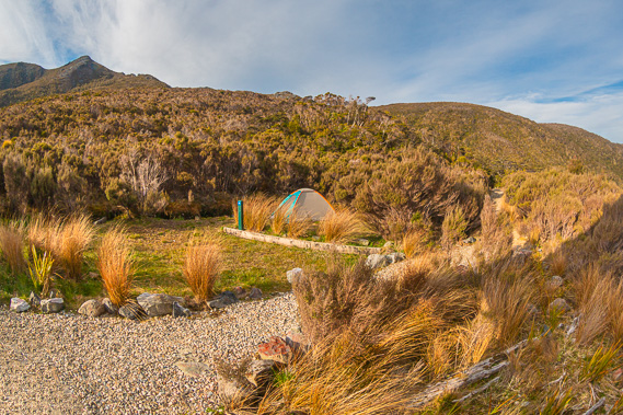 |
18:35 - I return climbing the steep track back to the hut, coming out at the washing area as part of the campground. The small campground on the other side of the hut has a small tent that had just been erected. A bearded guy and his partner are doing the final set up of the campsite. Obviously they are on too much of a budget to afford the much more luxurious huts. I was that way when I last came through here in 1996, opting to lug my small tent and set it up at each campsite where I stayed. The sun is attempting to come out in what would be the start of a spectacular sunset down the valley towards Gouland Downs. The jagged peaks of Devil’s Teeth stand dominant to the east towering above its forested skirts. |
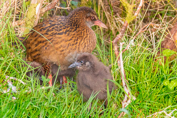 |
18:58 - I return to the bunkroom. Outside the window I notice some movement on the ground in the bush. The weka living by this hut is foraging around the thick grass. I looked more closely and realise it has a small chick with it. I have never seen a baby weka before. The mother has the usual mottled brown feathers, whereas the baby has black down feathers. They wander around at the edge of the bush foraging for small insects for a while before disappearing into the bush. |
 |
19:17 - I return to the dining area. Quite a few more people have by now arrived and everyone is jostling around getting their dinner. I am thankful I had an early dinner just before heading down to the mountain spa. It is a bit chaotic in here now.
|
 |
20:03 - The cloud to the west suddenly clears revealing the sun now shining brightly on the upper slopes of Mount Peel and onto the jagged tops of Devil’s Teeth. A chill is beginning to settle in. I’m sure even under the rays of sunlight the exposed ridge of Mount Peel I climbed down just a few hours ago is now getting very cold. |
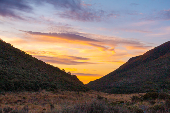 |
20:06 - The sun finally sinks beneath the horizon near the vee of the valley. The Devil’s teeth briefly turns red as the valley towards Gouland Downs turns bright yellow with the clearing cloud going purple. By now everyone has finished dinner and heading off to bed. Last night the hut was completely uninhabited. There are a lot of people here tonight. The other two bunk rooms are nearly full. My room is mostly empty apart from one young lady hiking alone who has kept very much to herself since arriving earlier this afternoon. She has already gone to bed in one of the other bunks. The remaining people staying here quickly clean up after dinner and head off to bed. No one has lit the fire tonight. It isn’t cold enough here inside the modern well insulated hut.
|
|