desktop view
|
Travel Diary
|
|
Blogs
|
Treks
|
Home
>
Treks
>
Inca Trail
The Inca Trail
Date:
Location:
Country:
Latitude:
Longitude:
Altitude:
13 - 18 October 2010
Inca Trail
Peru
13°18'S
72°15'W
2000 - 4215m ASL
Google Maps Link
Prologue
-
<< Start here
Day 1 - From Jungle to Mountains
Gasping for Breath
The Briefing
Day 2 - Descendants of the Inca
Leaving Cuzco
Potatoes and Incan Descendants
Mountain Storm
Ollantaytambo
Day 3 - Walking Amongst the Giants
Where Porters buy their Equipment
The Gate and the Swingbridge
Cemetary
Ruins at the Bend
The First of many Standing Ovations
The Camp is just past the Bridge
Day 4 - Mountain Passes in the Clouds
Overnight Rain and Snow
Climb to the Top Camp
The Climb to Dead Woman Pass
At the Summit
Steep Descent to Lunch
The Storm
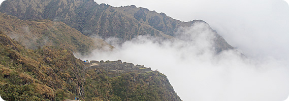
Ruins in the Clouds
Heavy Rain at the Campsite
Day 5 - Lost Cities of the Cloud Forest
I was up Early
The Inca Tunnel
Mountaintop Campsite
Ruins and Forests in the Sky
Campsite perched at the Edge of a Cliff
Forever Young
Farewell Dinner for the Porters
Day 6 - The City of Old Mountain
The Locked Gate
The Sungate
The Ultimate View and the Park Entrance
Tour around the City
We are down Here!
Residential area under the Mountain
Town at the Bottom of the Chasm
Return to Cusco
Epilogue
Blog from today:
The Inca Trail
Home
|
Travel Diary
|
|
Blogs
|
Treks
|
Who is Walkabout Jeff?
Follow Walkabout Jeff
© walkaboutjeff.com
Copyright
-
Disclaimer